Jet-powered Shahed drone reported moving from Odesa Oblast into southern Vinnytsia Oblast, Ukraine
What happened
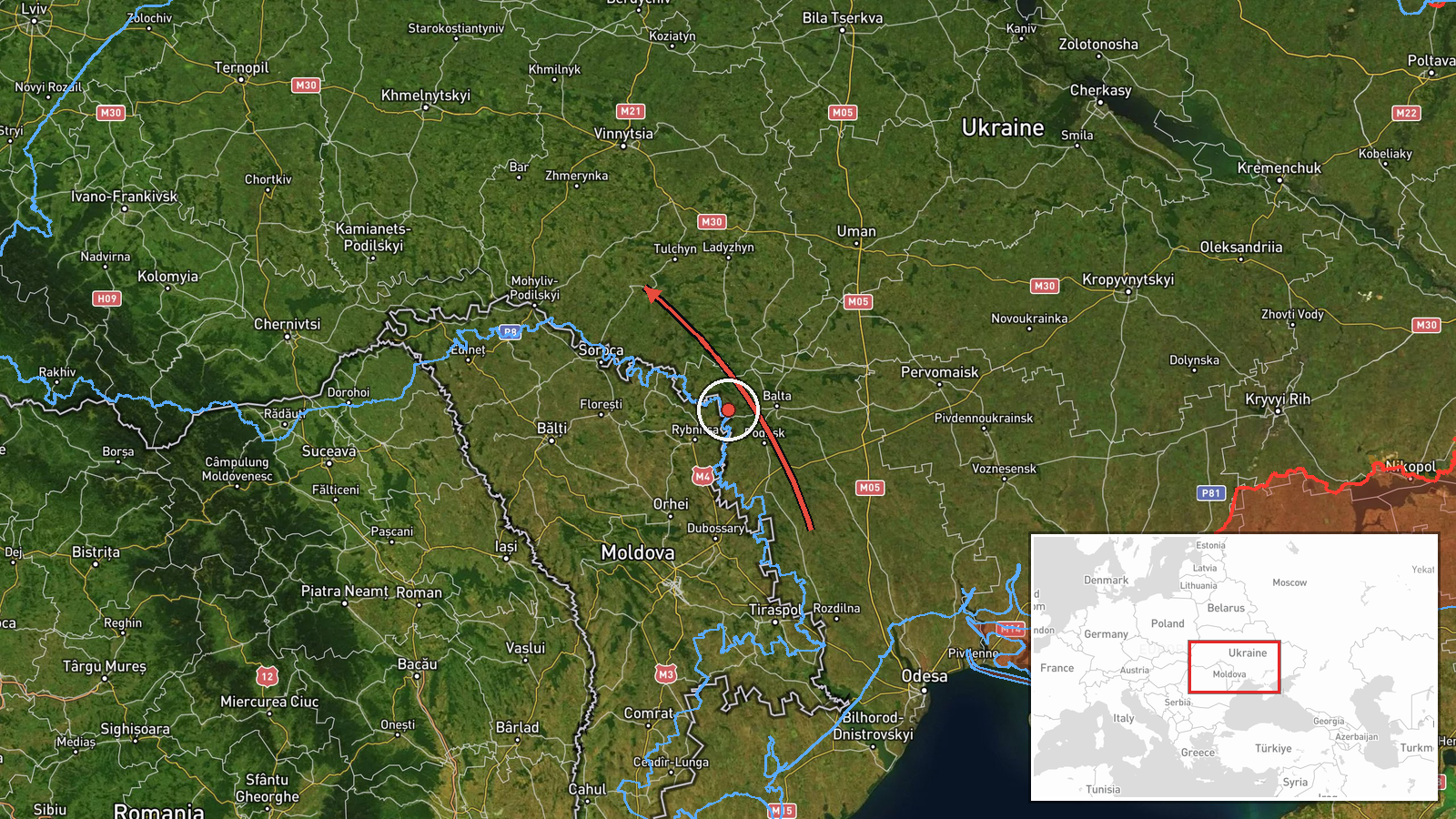
Ukraine's Air Force, posting on Telegram under the handle @kpszsu, reported on 20 October 2026 at 06:48 UTC that one Russian jet-powered Shahed, designated Geran-3, had entered from Odesa Oblast and was heading toward the southern part of Vinnytsia Oblast. The original Ukrainian wording, translated, describes a jet-type UAV moving south of the Vinnytsia region from Odesa region. The post is an air-monitoring alert rather than a confirmed impact report. It names no strike site, damage, casualties, or interception outcome. The event is logged under the broad label Drone Transit, and attribution to Russia rests on the monitoring statement and the Geran-3 designation used in the post.
Context and assessment
Vinnytsia Oblast lies in west-central Ukraine, and drones following routes from the south and southwest often cross it on the way toward western and central regions. The related events show a sustained pattern over roughly 36 hours. On 19 October the monitoring feed logged groups of two or more Geran-3 drones leaving Vinnytsia Oblast toward Tyvriv and Kryzhopil, followed by a single drone tracked west of Zhmerynka heading north. Early on 20 October a single drone from Odesa Oblast was tracked toward Rudnytsya. The current event places another drone from Odesa Oblast into the south of the region, and a further track toward Klembivka followed at 06:57 UTC. Repeated routing through the same districts suggests transit rather than attack on one fixed site, with air alerts following the drones across successive waypoints. Such sequences may point to launches from the south, route testing, or saturation tactics, but the alerts alone cannot distinguish these. The jet-powered variant is faster than piston-engine Shaheds, which helps explain why each track receives its own alert.
Sources and confidence
The event rests on a single channel, the Ukrainian Air Force Telegram post, which is the primary official air-monitoring feed that Ukrainian media routinely relay. The dataset contains no independent outlet, radar report, or second official source for this timestamp, so cross-confirmation is absent. The confidence score of 8.0 reflects an official origin and consistency with the surrounding alert sequence, but it is held below the top range by the single-source status and the lack of precise location. Confidence would rise with a second official or wire confirmation, a named impact site, or a shoot-down report. It would fall if later updates revised or retracted the track.
Location
The location is recorded at region level, not as a settlement or facility. The coordinates, about 48.68 N and 28.47 E, mark an approximate central point in southern Vinnytsia Oblast, and location confidence is rated low. The alert gives only a direction of travel from Odesa Oblast, so the exact track is unknown. The area is mostly rolling agricultural plain with river valleys, including the Southern Bug, and sparsely built rural districts lying between Odesa and the central oblasts.
Related events nearby
- Ukrainian air monitoring: 1 Russian jet-powered Shahed (Geran-3) drone from Vinnytsia Oblast toward Klembivka.2026-10-20 06:57 UTC · Drone Transit · Klembivka, Ukraine
- Ukrainian air monitoring: 2+ Russian jet-powered Shahed (Geran-3) drones from Vinnytsia Oblast toward Tyvriv.2026-10-19 07:45 UTC · Drone Transit · Tyvriv, Ukraine
- Ukrainian air monitoring: 2+ Russian jet-powered Shahed (Geran-3) drones from Vinnytsia Oblast toward Kryzhopi2026-10-19 14:08 UTC · Drone Transit · Kryzhopil, Ukraine
- Ukrainian air monitoring: one Russian jet-powered Shahed (Geran-3) drone tracked west of Zhmerynka in Vinnytsi2026-10-19 18:21 UTC · Drone Transit · West of Zhmerynka, Vinnytsia Oblast, Ukraine
- Ukrainian air monitoring: 1 Russian jet-powered Shahed (Geran-3) drone from Odesa Oblast toward Rudnytsya.2026-10-20 02:31 UTC · Drone Transit · Rudnytsya, Ukraine
▶ View this event on the live map

Intel Mapper aggregates open-source reports from monitored Telegram and X channels, geolocates them, cross-checks duplicates across sources and assigns a confidence score. Entries are updated as new confirmations arrive. Read how we verify events.