Ukrainian air monitoring reports 2+ jet-powered Shahed drones moving from Vinnytsia Oblast toward Kryzhopil
What happened
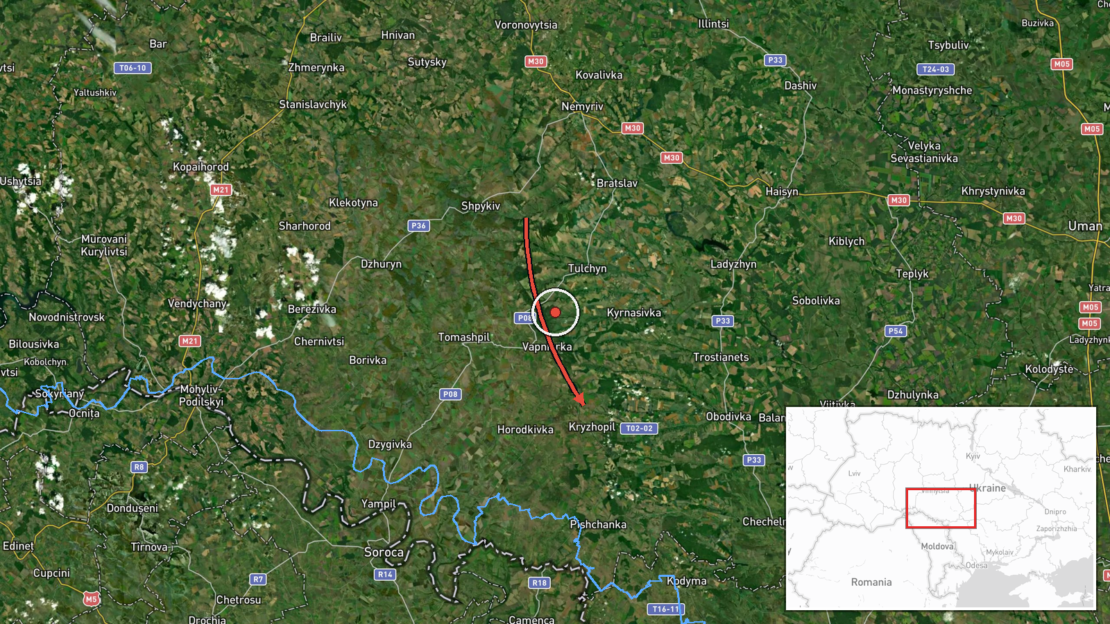
Ukrainian air monitoring reported at 14:08 UTC on 19 October 2026 that two or more Russian jet-powered Shahed (Geran-3) drones were moving from Vinnytsia Oblast toward Kryzhopil, a settlement in southern Vinnytsia Oblast. The original Ukrainian-language post, published on the Telegram channel @kpszsu, describes jet-type UAVs in the Vinnytsia region heading in the direction of Kryzhopil and Tulchyn. The Tulchyn reference appears as part of the original warning, not as a separate confirmed impact. The report describes a transit rather than a strike and gives no impact location, damage, casualties, or confirmed final destination. The phrase "2+" indicates a minimum count that may have changed as monitoring continued. Because the report comes from a single channel, the details should be read as an official alert that has not been independently corroborated on this page.
Context and assessment
Kryzhopil sits in the southern part of Vinnytsia Oblast, an area that has repeatedly appeared in air alerts as drones cross central and western Ukraine toward other regions. On the same day, the Intel Mapper timeline logged a sequence of transit reports across the oblast. Earlier reports placed a single Geran-3 passing Voronovytsya toward Zhmerynka, another drone heading toward Mohyliv-Podilskyy, and single and multiple drones moving past Haysyn toward Tulchyn and westward. A further group was reported from Vinnytsia Oblast toward Tyvriv in the morning. Taken together, these reports suggest a multi-hour pattern of drones crossing the oblast along several headings rather than a single isolated flight. Such transits can indicate routing toward targets farther west or south, or they may reflect drones being tracked as they move through air defense coverage zones. The short gaps between reports and the recurring use of the same towns imply sustained activity rather than one event. The timing alone does not reveal the intended target, so any inference about destination should remain provisional until further reporting appears.
Sources and confidence
This entry rests on a single Telegram channel, @kpszsu, which is widely associated with the Ukrainian Air Force's public air alerts. No second outlet, wire service, or local official in the dataset independently confirms the transit. The confidence score of 8.0 is high for an official military warning, but it is not higher because the report lacks a timestamped flight path, the count is a minimum, and nothing corroborates the destination. Confidence would rise with a follow-up air force update naming the final track, local authority statements, or independent radar or civil-defense reporting. It would fall if later official updates revised the drone type, the count, or the direction, or if the alert was withdrawn.
Location
The location is a settlement-level match to Kryzhopil, Ukraine, with high location confidence, placed at approximately 48.38 N, 28.87 E. The coordinates reflect the town rather than a specific facility, because the source did not name a point of impact or a military installation. Kryzhopil lies in southern Vinnytsia Oblast, in a largely agricultural landscape of rolling plains and river valleys. The nearby Tulchyn district and the wider Southern Bug basin are notable reference features in the surrounding area.
Related events nearby
- Ukrainian air monitoring: 1 Russian jet-powered Shahed (Geran-3) drone passing Haysyn, heading toward Tulchyn.2026-10-19 06:37 UTC · Drone Transit · Tulchyn, Ukraine
- Ukrainian air monitoring: 2+ Russian jet-powered Shahed (Geran-3) drones passing Haysyn, heading west.2026-10-19 07:38 UTC · Drone Transit · Haysyn, Ukraine
- Ukrainian air monitoring: 2+ Russian jet-powered Shahed (Geran-3) drones from Vinnytsia Oblast toward Tyvriv.2026-10-19 07:45 UTC · Drone Transit · Tyvriv, Ukraine
- Ukrainian air monitoring: 1 Russian jet-powered Shahed (Geran-3) drone heading toward Mohyliv-Podilskyy.2026-10-19 06:56 UTC · Drone Transit · Mohyliv-Podilskyy, Ukraine
- Ukrainian air monitoring: 1 Russian jet-powered Shahed (Geran-3) drone passing Voronovytsya, heading toward Zh2026-10-19 05:17 UTC · Drone Transit · Zhmerynka, Ukraine
▶ View this event on the live map

Intel Mapper aggregates open-source reports from monitored Telegram and X channels, geolocates them, cross-checks duplicates across sources and assigns a confidence score. Entries are updated as new confirmations arrive. Read how we verify events.