Ukrainian air monitoring reports one Russian Banderol cruise missile launched from Sumy Oblast toward Krolevets
What happened
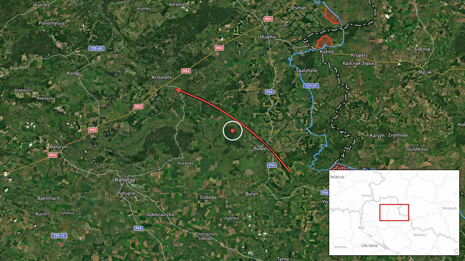
Ukrainian air monitoring channels reported on 21 October 2026 at about 04:53 UTC that one Russian Banderol mini cruise missile was flying from Sumy Oblast toward the town of Krolevets in Sumy Oblast, northeastern Ukraine. The only source is the Telegram channel @kpszsu, which posted a short alert whose original wording reads roughly as a Banderol flying toward Krolevets in Sumy region. The post does not report impact, damage, casualties, or interception. The origin is given as Sumy Oblast in the summary but no specific launch point is recorded. Because the report is a brief air-alert style notice, its details reflect what the monitoring channel observed at the time rather than confirmed results on the ground.
Context and assessment
Krolevets lies close to the Russian border in northern Sumy Oblast, and this part of the frontier has seen repeated cross-border pressure throughout the war. The event sits within a cluster of activity in the preceding day. Earlier on 20 October, Ukrainian monitoring recorded jet-powered Shahed-type Geran-3 drones moving toward Buryn, Mena and Sumy, and a further Shahed-type drone heading toward Mykolayiv. Separately, a report of two airstrikes, five KAB glide bombs and 38 shellings was logged near Kindrativka on the Sumy front line. Taken together, the sequence suggests a sustained, multi-axis effort against the Sumy border area, combining long-range drones, guided bombs and artillery. A cruise missile such as the Banderol, which is a small low-flying weapon, is typically associated with striking specific fixed targets rather than area saturation, so its appearance may point to a deliberate target in or near Krolevets. That inference is tentative, since the report does not name a target, and the missile type mix in the cluster may also reflect routine rotation of available weapons rather than a shift in intent.
Sources and confidence
The event rests on one Telegram channel, @kpszsu, which relays Ukrainian air monitoring alerts. No second outlet, official statement or independent observer is recorded as confirming the missile or its trajectory, so cross-confirmation is absent and the confidence score of 8.0 reflects a single source that is specific in its wording and location but unverified. Confidence would rise with a corroborating air force notice, regional military administration statement, or imagery or local reporting of impact or debris in Krolevets. It would fall if the alert were revised, withdrawn, or contradicted by later official accounts. The event is not marked as corrected.
Location
The coordinates correspond to the settlement of Krolevets, a town in northern Sumy Oblast, placed at settlement-level precision with high location confidence. The point is a settlement centroid rather than a specific facility or street. The town lies in the flat, forested and river-laced terrain of the Ukrainian northeast, a few tens of kilometres from the Russian border. The nearby Desna and Seym river basins and the broader Sumy agricultural plain shape local movement corridors.
Related events nearby
- Russian shelling hit about 20 settlements in Sumy Oblast, and an airstrike hit Pustohorod; Chernihiv Oblast's 2026-10-21 05:03 UTC · Artillery · Bezsalivka, Sumy Oblast, Ukraine
- Ukrainian air monitoring: 2+ Russian jet-powered Shahed (Geran-3) drones heading toward Mena.2026-10-20 17:14 UTC · Drone Transit · Mena, Ukraine
- Russian forces conducted two airstrikes, five KAB glide bombs and 38 shellings against Ukrainian positions and2026-10-20 19:02 UTC · Airstrike · Near Kindrativka, Sumy, Ukraine (front line, estim
- Ukrainian air monitoring: 1 Russian Shahed-type drone heading toward Sumy; 1 Russian Shahed-type drone heading2026-10-20 13:49 UTC · Drone Transit · Sumy, Ukraine
- Ukrainian air monitoring: 1 Russian Shahed-type drone heading toward Sumy.2026-10-20 10:32 UTC · Drone Transit · Sumy, Ukraine
▶ View this event on the live map

Intel Mapper aggregates open-source reports from monitored Telegram and X channels, geolocates them, cross-checks duplicates across sources and assigns a confidence score. Entries are updated as new confirmations arrive. Read how we verify events.