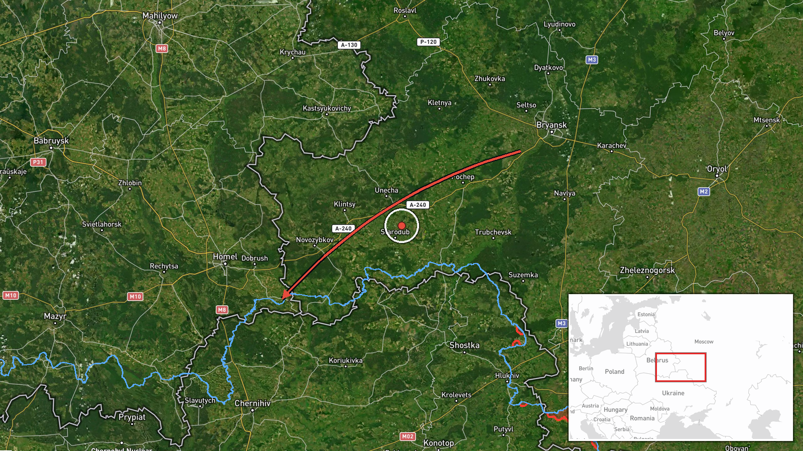
Single Geran-3 jet drone reported transiting from Bryansk toward northern Chernihiv Oblast
What happened
Ukrainian air monitoring channel @kpszsu reported on 21 October 2026 at about 07:40 UTC that one Russian jet-powered Shahed, designated Geran-3, had been detected moving from Bryansk Oblast in Russia toward the north of Chernihiv Oblast in Ukraine. The original post, written in Ukrainian, describes it as a jet-type UAV ("Реактивний БпЛА") crossing from Bryansk region to the north of Chernihiv region. The report does not mention impacts, casualties, or a specific target. The location is given only at regional level, and the event is recorded as a transit rather than a confirmed strike. The information comes from a single channel and has not yet been matched by a second independent source.
Context and assessment
Northern Chernihiv Oblast sits close to the Russian border, and drones entering from Bryansk frequently follow routes across this corridor toward Kyiv, Chernihiv city, and the Desna valley. This report belongs to a cluster of activity in the same area over roughly 36 hours. On 20 October, Ukrainian monitoring logged 3 or more Geran-3 drones passing Nova toward northern Chernihiv, then 2 or more passing Slavutych heading south. On 21 October, further groups of 2 or more were tracked near Mykhailo-Kotsiubynske heading south and over northern Chernihiv early that morning, and a single Banderol mini cruise missile was reported heading toward Chernihiv city at 05:10. The pattern suggests repeated probing or transit flights along the same axis rather than an isolated launch. Operationally, a single drone may be a decoy, a navigation test, or a fragment of a larger wave that is only partly observed. The sequence reads as continuing pressure on Chernihiv region's air defence and warning system, though the reports alone do not show intent or the final destination.
Sources and confidence
The event rests on one Ukrainian military-affiliated Telegram channel, @kpszsu, which relays air monitoring alerts. Related reports in the cluster come from the same type of channel, so they share a single-source origin. No independent confirmation from wire services, local officials, or open-source drone trackers is recorded. The confidence score of 8 out of 10 reflects a credible official-linked channel with consistent alert patterns over several days, but it is held below the top range because the report is single-sourced and describes only a transit. Confidence would rise with corroboration from Ukrainian air force statements, regional authorities, or independent flight-tracking. It would fall if later reporting contradicts the drone type or direction.
Location
The location was set to the broad region of northern Chernihiv Oblast, not a settlement, because the original post names only the area. The coordinates are approximate, and the low location confidence reflects this. The area is mostly flat to gently rolling terrain of the Polissia lowlands, with forests, marshes, and river systems. The Desna and Snov rivers run through the wider region, and the border with Russia lies a short distance to the north and east.
Related events nearby
- Ukrainian air monitoring: 2+ Russian jet-powered Shahed (Geran-3) drones over northern Chernihiv Oblast.2026-10-21 04:07 UTC · Drone Transit · northern Chernihiv Oblast, Ukraine
- Ukrainian air monitoring: 3+ Russian jet-powered Shahed (Geran-3) drones passing Nova, heading toward northern2026-10-20 17:12 UTC · Drone Transit · northern Chernihiv Oblast, Ukraine
- Ukrainian air monitoring: 1 Russian Banderol mini cruise missile heading toward Chernihiv.2026-10-21 05:10 UTC · Cruise Missile · Chernihiv, Ukraine
- Ukrainian air monitoring: 2+ Russian jet-powered Shahed (Geran-3) drones passing Mykhailo-Kotsiubynske, headin2026-10-21 04:18 UTC · Drone Transit · Mykhailo-Kotsiubynske, Ukraine
- Ukrainian air monitoring: 2+ Russian jet-powered Shahed (Geran-3) drones passing Slavutych, heading south.2026-10-20 09:31 UTC · Drone Transit · Slavutych, Ukraine
▶ View this event on the live map

Intel Mapper aggregates open-source reports from monitored Telegram and X channels, geolocates them, cross-checks duplicates across sources and assigns a confidence score. Entries are updated as new confirmations arrive. Read how we verify events.