Air monitoring reports 3+ Geran-3 jet drones near Nova, heading toward Chernihiv Oblast
What happened
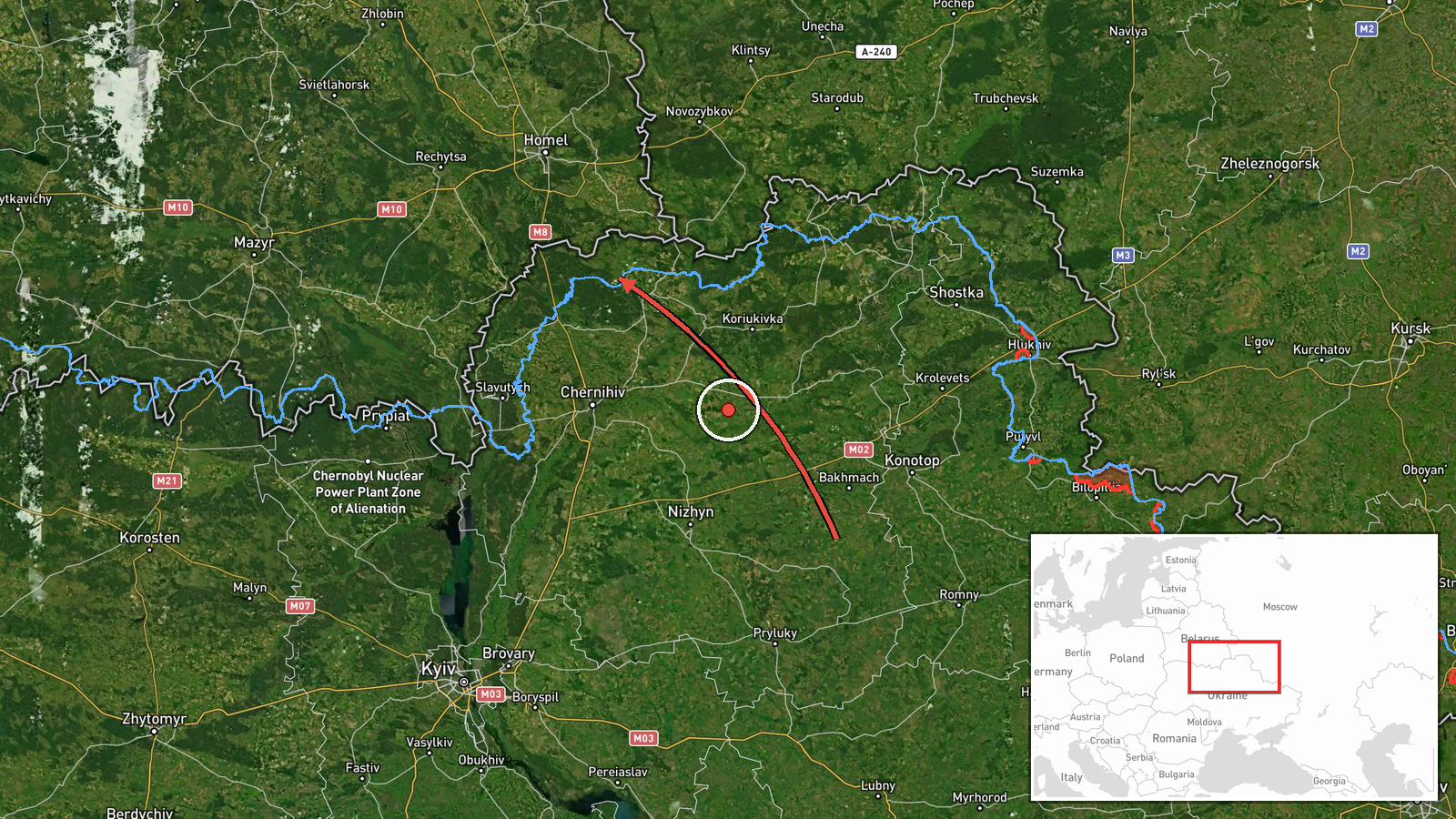
On 20 October 2026 at 17:12 UTC, the Telegram channel of Ukraine's Air Force (@kpszsu) reported that a new group of Russian jet-powered Shahed-type drones, identified as Geran-3, was moving across northern Ukraine. The post said at least three drones were passing the settlement of Nova and heading toward northern Chernihiv Oblast, near the Belarusian border. The original Ukrainian wording, translated, describes new groups of jet-powered UAVs arriving from Bryansk Oblast in Russia toward northern Chernihiv Oblast. The report does not say whether the drones were armed, whether they struck a target, or whether any damage or casualties occurred. It is a single-channel air alert logged as a drone transit, not an impact report.
Context and assessment
Northern Chernihiv Oblast sits close to the Belarusian and Russian borders, and the city of Chernihiv and nearby Slavutych lie along routes that Russian long-range drones have used repeatedly since 2022. The related events in this record show a sustained pattern over roughly 24 hours on 19 and 20 October 2026. Monitoring logged groups of two or more Geran-3 drones heading toward Chernihiv at 21:01 UTC on 19 October, passing near Nova toward Chernihiv Oblast at 23:44, and moving from northern Kyiv Oblast toward northern Chernihiv Oblast at 00:14 on 20 October. Further alerts placed groups passing Slavutych at 07:29 and 09:31, with one heading south. Taken together, the sequence suggests drones entering the region in successive waves and crossing it along a north-south axis, rather than a single isolated flight. Operationally, repeated transits of this kind are often associated with reconnaissance of air defence coverage, with routing designed to stretch defences, or with groups moving toward targets further south. The data does not establish which purpose applies. Jet-powered Geran-3 variants are generally assessed as faster and harder to intercept than older propeller-driven Shaheds, which makes early warning especially valuable. Because these records are transit reports, they cannot confirm intended targets.
Sources and confidence
The event rests on one Telegram channel, @kpszsu, which carries Ukrainian Air Force air-threat updates. No second outlet in the dataset independently reports this transit, so cross-confirmation is absent. The score of 8.0 reflects an official military source and a time-stamped, specific report, offset by single-source status. Confidence would rise if regional administrations, independent flight-tracking accounts or later impact reports confirmed the same drones. It would fall if updates revised the number, direction or route of the drones, or retracted the alert.
Location
The coordinates, about 52.08 N, 31.29 E, are region-level, centred on northern Chernihiv Oblast rather than a settlement, facility or flight track. Location confidence is low: the report names Nova as a passing point, but the exact position is unstated. The terrain is mostly flat lowland of the Desna basin, with forest and marsh, and the Belarusian border lies just to the north. Chernihiv city and Slavutych are the nearest named reference points.
Related events nearby
- Ukrainian air monitoring: 2+ Russian jet-powered Shahed (Geran-3) drones from northern Kyiv Oblast toward nort2026-10-20 00:14 UTC · Drone Transit · northern Chernihiv Oblast, Ukraine
- Ukrainian air monitoring: 3+ Russian jet-powered Shahed (Geran-3) drones passing Nova, heading toward Chernihi2026-10-19 23:44 UTC · Drone Transit · Chernihiv Oblast, Ukraine
- Ukrainian air monitoring: 2+ Russian jet-powered Shahed (Geran-3) drones heading toward Chernihiv.2026-10-19 21:01 UTC · Drone Transit · Chernihiv, Ukraine
- Ukrainian air monitoring: 2+ Russian jet-powered Shahed (Geran-3) drones passing Slavutych, heading south.2026-10-20 09:31 UTC · Drone Transit · Slavutych, Ukraine
- Ukrainian air monitoring: 2+ Russian jet-powered Shahed (Geran-3) drones from northern Chernihiv Oblast toward2026-10-20 07:29 UTC · Drone Transit · Slavutych, Ukraine
▶ View this event on the live map

Intel Mapper aggregates open-source reports from monitored Telegram and X channels, geolocates them, cross-checks duplicates across sources and assigns a confidence score. Entries are updated as new confirmations arrive. Read how we verify events.