Ukrainian air monitoring reports group of jet-powered Shahed drones heading toward Ochakiv
What happened
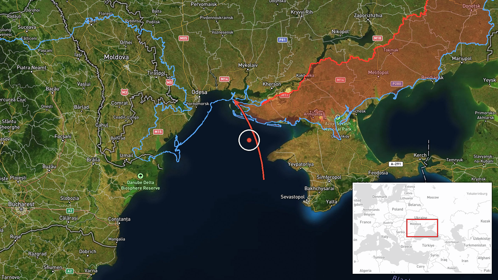
On 21 October 2026, at 08:11 UTC, Ukrainian air monitoring reported groups of jet-powered unmanned aerial vehicles moving from the Black Sea toward Ochakiv, a port town in Mykolaiv Oblast in southern Ukraine. The original Ukrainian-language post, published on the Telegram channel @kpszsu, describes 'groups of jet-powered UAVs' traveling from the sea in the direction of Ochakiv and does not give a count. The English summary characterizes the group as at least three Russian Geran-3 type jet-powered Shahed drones, a figure that reflects the summary rather than the original wording. The report does not describe any impact, casualties, or damage, and it does not identify a final target. The event is classified as drone transit, meaning it concerns movement of aircraft rather than a confirmed strike.
Context and assessment
Ochakiv sits on the Black Sea coast at the mouth of the Dnipro-Bug estuary, close to the Kinburn Spit and the approaches to Mykolaiv, a major shipbuilding and port city further up the estuary. Control of this coastline has been contested since the early stages of the full-scale war, and the port area has been a recurring focus for Russian long-range strikes and for Ukrainian efforts to keep shipping lanes open. The related reports form a clear sequence over roughly 26 hours. On 20 October, single Shahed-type drones were logged passing Berezanka twice, first at 08:44 and then at 10:11, both heading northwest, followed by a drone from the Black Sea toward Rybakivka at 15:47. On 21 October, a single Geran-3 was reported over Ochakiv at 04:10, another was heading toward Mykolaiv at 06:13, and the current report describes a larger group approaching Ochakiv from the sea. The pattern suggests a route that runs along the coast and estuary, with the drones tracked successively across settlements in the same corridor. Operationally, this may indicate route probing, reconnaissance of air defense response times, or preparation for a larger coordinated attack. These explanations cannot be confirmed from a transit report alone, and the sequence may equally reflect routine flight paths toward inland targets.
Sources and confidence
The report comes from a single Telegram channel, @kpszsu, and no other outlet in the provided data has independently confirmed it. The channel's association with Ukrainian air monitoring gives the post institutional weight, and the related events from the same period share the same source type, which supports the consistency of the sequence. The confidence score of 8.0 reflects a credible official-style channel with a precise timestamp and location, offset by the absence of cross-confirmation and the lack of an independent count. Confidence would rise with corroboration from Ukrainian Air Force statements, regional military administration reports, or independent tracking that matches the same route and time. It would fall if subsequent reporting contradicts the drone type, the number involved, or the direction of travel.
Location
The location is tagged at settlement level, with coordinates at the centre of Ochakiv rather than a specific facility, so the pin indicates the town rather than any installation. The coordinates are recorded with high location confidence. Ochakiv lies on the northern Black Sea coast in Mykolaiv Oblast, near the Dnipro-Bug estuary and the Kinburn Spit, which separates the estuary from the open sea. The flat, low-lying terrain of the Black Sea lowlands offers little natural cover for low-flying drones, and the estuary and coastline form a natural approach corridor.
Related events nearby
- Ukrainian air monitoring: 1 Russian jet-powered Shahed (Geran-3) drone over Ochakiv.2026-10-21 04:10 UTC · Drone Transit · Ochakiv, Ukraine
- Ukrainian air monitoring: 1 Russian Shahed-type drone from Black Sea toward Rybakivka.2026-10-20 15:47 UTC · Drone Transit · Rybakivka, Ukraine
- Ukrainian air monitoring: 1 Russian jet-powered Shahed (Geran-3) drone passing Berezanka, heading northwest.2026-10-20 10:11 UTC · Drone Transit · Berezanka, Ukraine
- Ukrainian air monitoring: 1 Russian jet-powered Shahed (Geran-3) drone heading toward Mykolaiv.2026-10-21 06:13 UTC · Drone Transit · Mykolaiv, Ukraine
- Ukrainian air monitoring: 2+ Russian jet-powered Shahed (Geran-3) drones passing Nova Odesa, heading north.2026-10-21 08:32 UTC · Drone Transit · Nova Odesa, Ukraine
▶ View this event on the live map

Intel Mapper aggregates open-source reports from monitored Telegram and X channels, geolocates them, cross-checks duplicates across sources and assigns a confidence score. Entries are updated as new confirmations arrive. Read how we verify events.