Ukraine reports 2+ jet-powered Shahed drones moving from Chernihiv toward Kyiv Oblast
What happened
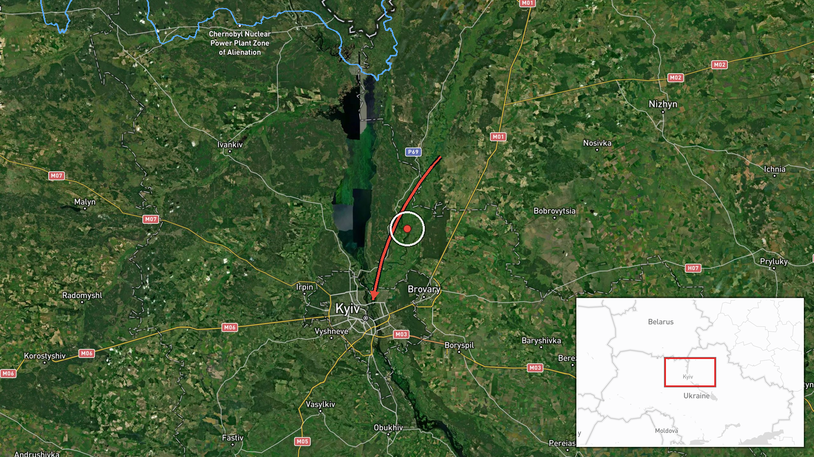
Ukrainian air monitoring reported on 21 October 2026, at 15:39 UTC, that at least two jet-powered Russian Shahed drones, identified in the post as Geran-3, were moving from Chernihiv Oblast toward Kyiv Oblast. The notice was published on the Telegram channel @kpszsu, which carries Ukrainian air-threat updates. The original Ukrainian wording is brief, describing jet-type unmanned aerial vehicles flying from Chernihiv region to Kyiv region. It gives no altitude, exact track, intended target, or impact. This is a transit notice rather than a strike report, so no damage or casualties are described. The post is one of several similar updates logged for the same day.
Context and assessment
Kyiv Oblast surrounds the capital and sits within reach of drone routes that run south from the Chernihiv and Belarus border area, so repeated transit reports here are a regular feature of Russian long-range drone activity. The Geran-3 is a jet-powered variant of the Shahed design, generally described as faster and harder to engage than the piston-engined Geran-2, which makes each transit more consequential for air defense planning. The related events on this page show a sustained pattern through the day. Reports at 02:37 and 03:43 UTC placed drones over or heading toward Kyiv city, followed by 07:58 UTC passing Olyshivka on the approach, then 08:55 UTC passing Kyiv Oblast heading west, and 11:39 UTC heading toward the oblast again. Such a sequence may indicate reconnaissance, route probing, or an effort to stretch and draw out air defense coverage, though the feed itself does not confirm intent. Without impact reports, the most that can be said is that the drones were tracked moving through the region.
Sources and confidence
All evidence on this event comes from one Telegram channel, @kpszsu, and no independent outlet or second monitoring source is recorded in the data. The related events are drawn from the same type of Ukrainian air-monitoring feed, so they add pattern context but do not independently confirm this report. The confidence score of 8.0 reflects the channel's established role in publishing air-threat alerts and the specificity of the drone type and route, offset by the absence of cross-confirmation. Confidence would rise with corroboration from Ukrainian Air Force statements, regional military administrations, or other monitoring accounts. It would fall if later official updates contradicted the direction of travel or the drone count.
Location
The location is recorded at region level, Kyiv Oblast, and the coordinates provided (50.45, 30.52) correspond to the center of Kyiv city rather than a precise point in the oblast. The location confidence is therefore low, and the pin should be read as an approximate area rather than a specific site. The setting is largely flat, with the Dnipro River valley to the east and the Chernihiv region bordering to the north. Kyiv Oblast wraps around the capital, so the pin does not indicate where the drones were or what they targeted.
Related events nearby
- Ukrainian air monitoring: 2+ Russian jet-powered Shahed (Geran-3) drones heading toward Kyiv Oblast.2026-10-21 11:39 UTC · Drone Transit · Kyiv Oblast, Ukraine
- Ukrainian air monitoring: 2+ Russian jet-powered Shahed (Geran-3) drones passing Kyiv Oblast, heading west.2026-10-21 08:55 UTC · Drone Transit · Kyiv Oblast, Ukraine
- Ukrainian air monitoring: 2+ Russian jet-powered Shahed (Geran-3) drones passing Olyshivka, heading toward Kyi2026-10-21 07:58 UTC · Drone Transit · Kyiv Oblast, Ukraine
- Ukrainian air monitoring: 1 Russian jet-powered Shahed (Geran-3) drone heading toward Kyiv.2026-10-21 03:43 UTC · Drone Transit · Kyiv, Ukraine
- Ukrainian air monitoring: 2+ Russian jet-powered Shahed (Geran-3) drones over Kyiv.2026-10-21 02:37 UTC · Drone Transit · Kyiv, Ukraine
▶ View this event on the live map

Intel Mapper aggregates open-source reports from monitored Telegram and X channels, geolocates them, cross-checks duplicates across sources and assigns a confidence score. Entries are updated as new confirmations arrive. Read how we verify events.