Jet-powered Geran-3 drones tracked westward south of Dnipro, Ukrainian air monitoring reports
What happened
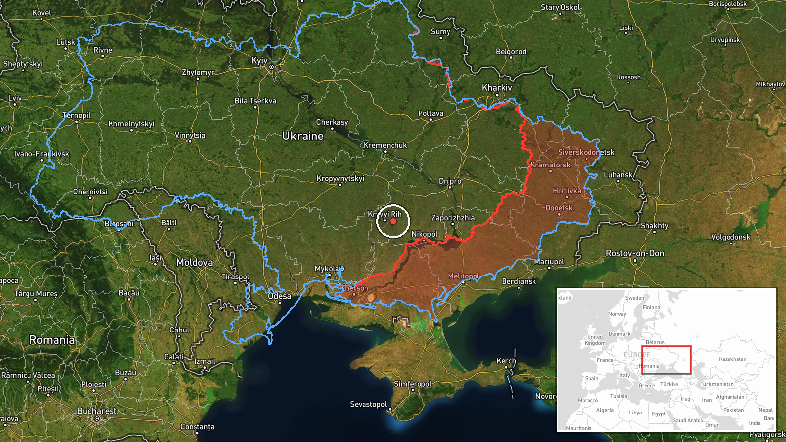
The Telegram channel @kpszsu, which carries Ukrainian air force monitoring updates, reported at 18:50 UTC on 21 October 2026 that jet-powered Shahed (Geran-3) drones were tracked south of Dnipro and north of Kropyvnytskyi, on a westward heading. The original Ukrainian wording is brief: "Реактивні БпЛА на півдні від Дніпра та півночі від Кропивницького, курс на захід." The post does not give a drone count, although related monitoring posts from the same day describe two or more. No impacts, casualties, or targets are reported in this item. The summary places the activity in southern Dnipropetrovsk Oblast, but the stated reference points are relative positions rather than a fixed site, so the report describes a flight corridor rather than a location of attack.
Context and assessment
Dnipro and Kropyvnytskyi sit along the central Ukrainian corridor that links the industrial east with the western regions. The track described here crosses the same area as several earlier posts that day. At 05:58 drones were reported passing Bereznehuvate heading north. At 15:48 and 18:04, groups of two or more were reported heading toward Kryvyi Rih. At 18:30, drones were passing southern Dnipropetrovsk Oblast heading west. A separate entry at 18:08 describes guided aerial bombs launched against southeastern Dnipropetrovsk Oblast near the front line near Nikopol, which points to a parallel front-line strike pattern in the same oblast. Taken together, the sequence suggests repeated waves over the region rather than a single launch. Operationally, a westward heading past these points may indicate routing toward targets farther west, a diversion, or simply the drones' flight path, but the data cannot establish intent. Jet-powered Geran-3 variants are generally associated with higher speed than propeller-driven Shaheds, which can shorten warning windows. That is a general capability note, not a finding from this report. The absence of impact reporting here should not be read as absence of effect.
Sources and confidence
This is a single-source report from the Telegram channel @kpszsu, the Ukrainian air force's monitoring feed. The related events appear to derive from the same Ukrainian air force reporting stream, so they add pattern context but are not independent confirmation. No second outlet, independent sensor data, imagery, or wreckage report is attached. The confidence score of 8.0 reflects an official, timely, and specific tracking report that fits a consistent pattern. It stays below the top range because there is one channel, the drone count is only given as two or more in related items, and no impacts are verified. Confidence would rise with corroboration from other Ukrainian or independent monitoring, impact or debris reports, or a confirmed target. It would fall if later updates revised the track or identified the objects as decoys.
Location
The location is region-level, with low location confidence. The coordinates of 47.9 N, 33.6 E are an approximate centroid for southern Dnipropetrovsk Oblast, not a settlement or facility. The report gives only relative positions between Dnipro and Kropyvnytskyi. The centroid falls close to Kryvyi Rih, which is named in related events, so the point may be pulled toward that city. The terrain is mostly steppe and farmland, with the Dnipro river valley to the northeast and a dense network of rail and road links running across the oblast.
Related events nearby
- Ukrainian air monitoring: 2+ Russian jet-powered Shahed (Geran-3) drones passing southern Dnipropetrovsk Oblas2026-10-21 18:30 UTC · Drone Transit · southern Dnipropetrovsk Oblast, Ukraine
- Ukrainian air monitoring: 2+ Russian jet-powered Shahed (Geran-3) drones heading toward Kryvyy Rih.2026-10-21 15:48 UTC · Drone Transit · Kryvyy Rih, Ukraine
- Ukrainian air monitoring: 2+ Russian jet-powered Shahed (Geran-3) drones heading toward Kryvyi Rih.2026-10-21 18:04 UTC · Drone Transit · Kryvyi Rih, Ukraine
- Russian tactical aviation launched guided aerial bombs (KABs) against southeastern Dnipropetrovsk Oblast, per 2026-10-21 18:08 UTC · Airstrike · Near Nikopol, Dnipropetrovsk, Ukraine (front line,
- Ukrainian air monitoring: 2+ Russian jet-powered Shahed (Geran-3) drones passing Bereznehuvate, heading north.2026-10-21 05:58 UTC · Drone Transit · Bereznehuvate, Ukraine
▶ View this event on the live map

Intel Mapper aggregates open-source reports from monitored Telegram and X channels, geolocates them, cross-checks duplicates across sources and assigns a confidence score. Entries are updated as new confirmations arrive. Read how we verify events.