Russian Shahed drone transits toward Oleksandriya as strikes continue on Poltava region
What happened
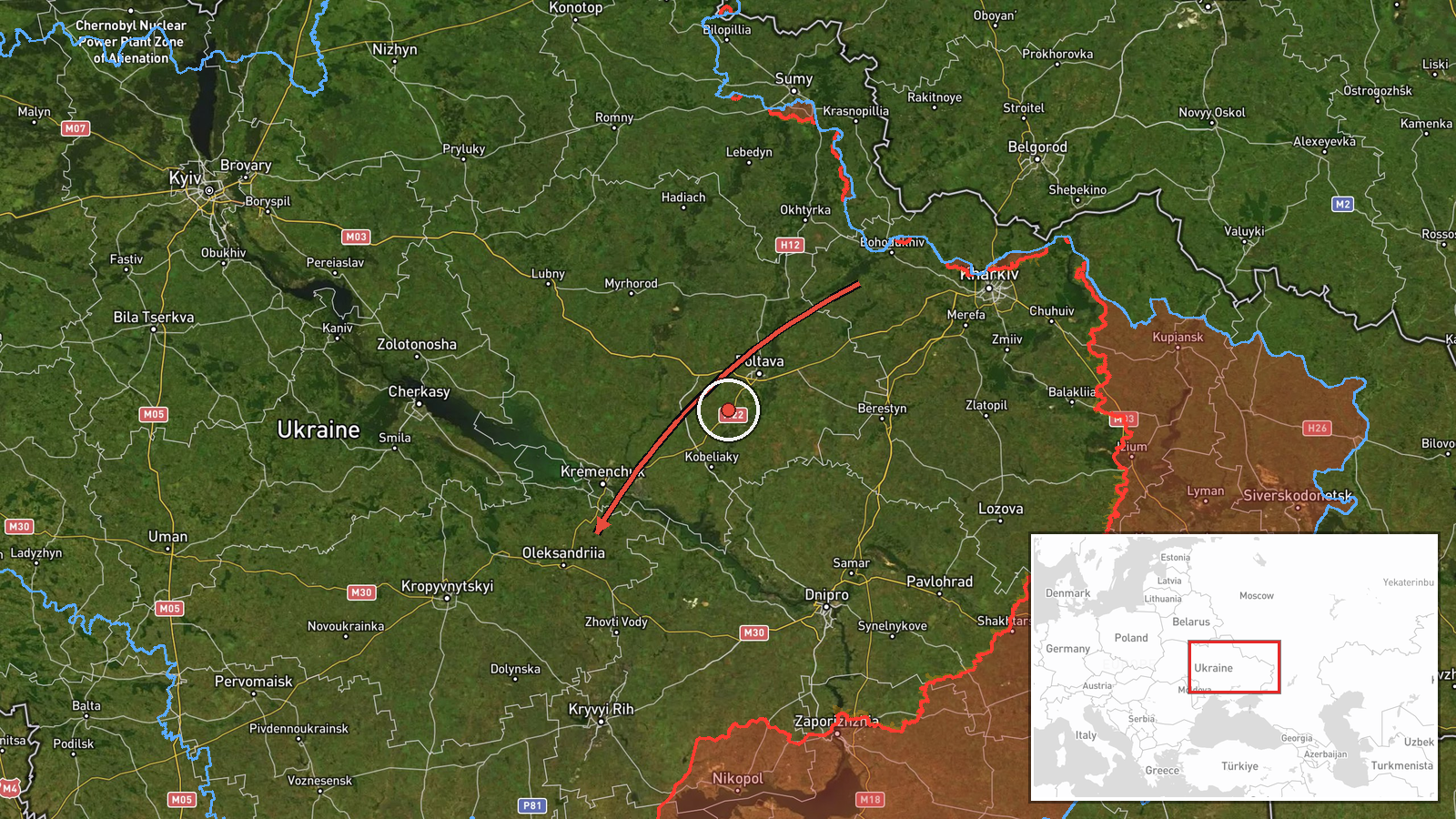
Ukrainian air monitoring reported one Russian Shahed-type drone passing over Bohodukhiv and heading toward Oleksandriya on October 14 at 14:49 UTC. The report, issued in Ukrainian, noted that most Shahed-2 (also called Gerbera-2) drones were stretched across the route from Bohodukhiv to Oleksandriya, with the Oleksandriya and broader Poltava region under attack. This represents the latest in a series of Russian unmanned aircraft operations targeting the area.
Context and assessment
Oleksandriya, located in central Poltava Oblast, has been repeatedly targeted over the past 24 hours. Earlier on October 14, Ukrainian monitors detected 8 Shahed drones over the city at 12:28 UTC, followed by a mixed strike package of 3 Shahed drones and 3 Banderol mini cruise missiles at 13:02 UTC. The sustained tempo of attacks on Poltava region—including nearby Horishni Plavni and Kremenchuk district—suggests Russia is conducting a coordinated campaign against infrastructure in central Ukraine. The pattern may indicate attempts to degrade power, communications, or military logistics nodes serving Ukrainian operations.
Sources and confidence
Single source: Telegram channel @war_monitor, a Ukrainian air monitoring account. The report lacks independent cross-confirmation from other open-source monitors or official Ukrainian defense statements. Confidence score of 6.0 reflects the source's typical reliability for transit observations but the absence of corroborating reports. Confirmation from second monitoring channel or official statement would raise confidence; contradictory reports or editing of the source post would lower it.
Location
Oleksandriya is a settlement in Poltava Oblast, central Ukraine, located approximately 48.67°N, 33.12°E. The city sits on the Oril River roughly 190 kilometers southeast of Kyiv. The drone transit from Bohodukhiv (to the north) toward Oleksandriya follows a common Russian ingress route across central Ukrainian airspace targeting regional military and civilian infrastructure.
Related events nearby
- Ukrainian air monitoring: 3 Russian Shahed-type drones over Oleksandriya; 3 Russian Banderol mini cruise missi2026-10-14 13:02 UTC · Cruise Missile · Oleksandriya, Ukraine
- Ukrainian air monitoring: 8 Russian Shahed-type drones over Oleksandriya.2026-10-14 12:28 UTC · Drone Transit · Oleksandriya, Ukraine
- Ukrainian air monitoring: 6 Russian Shahed-type drones passing Donetsk, heading toward Kremenchuk district.2026-10-14 07:39 UTC · Drone Transit · Kremenchuk district, Ukraine
- Ukrainian air monitoring: 1 Russian Shahed-type drone heading toward Kremenchuk.2026-10-13 17:40 UTC · Drone Transit · Kremenchuk, Ukraine
- Ukrainian air monitoring: 8 Russian Shahed-type drones over Horishni Plavni.2026-10-14 12:16 UTC · Drone Transit · Horishni Plavni, Ukraine
▶ View this event on the live map

Intel Mapper aggregates open-source reports from monitored Telegram and X channels, geolocates them, cross-checks duplicates across sources and assigns a confidence score. Entries are updated as new confirmations arrive. Read how we verify events.