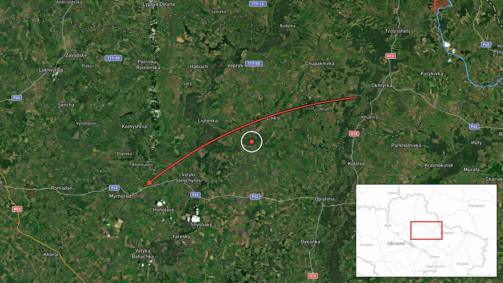
Russian Banderol cruise missile reported from Okhtyrka toward Myrhorod, Poltava Oblast
What happened
Ukrainian air monitoring reported on 18 October 2026 at 19:14 UTC that one Russian Banderol mini cruise missile was passing Okhtyrka and heading toward Myrhorod in Poltava Oblast. The alert appeared in a Telegram post from the channel @war_monitor, which published it in Ukrainian under a regional Poltava heading. The wording describes a track in progress. It does not report detonation, damage, casualties, or an intercept. No second channel in the dataset carries the report, so it is classed as single-source. Two related entries also appear: a missile over Myrhorod itself at 18:40 UTC, and a separate Banderol passing Romny toward Pryluky at 19:19 UTC. These are logged as distinct events and are not confirmed as the same object.
Context and assessment
Myrhorod is a mid-sized city in Poltava Oblast, in central-eastern Ukraine, and it has appeared in air alerts because of its airfield and its position on routes linking the northeastern border region with the Dnipro and Kremenchuk areas. The cited track runs from Okhtyrka, a town in Sumy Oblast near the Russian border, toward the southwest, which is consistent with a missile approaching from the north-east. The related entries show a busier pattern across the same corridor that day. Between 06:35 and 06:45 UTC the feed logged several jet-powered Shahed-type drone transits over Poltava, with residents told to shelter. The 18:40 UTC entry over Myrhorod suggests the same air picture was being tracked there roughly half an hour before this report. Operationally, the sequence may point to a combined effort against the region's infrastructure, though the feed does not identify targets. Low-flying cruise missiles of this type are generally assessed as difficult to track, so a single-source report carries uncertainty about the track itself as well as about intent.
Sources and confidence
The report comes from one Telegram channel, @war_monitor, and no second outlet in the dataset carries it. The confidence score of 6.0 is moderate. It reflects a specific track description, a timestamp, and a clear regional heading, but no independent confirmation, imagery, or official statement. Confidence would rise if a second monitoring channel, an official air alert, or regional authorities corroborated the track, or if impact or debris reports appeared. It would fall if the entry were revised, found to duplicate an earlier track, or contradicted by later airspace updates. The entry is not marked as corrected.
Location
The coordinates correspond to the settlement of Myrhorod in Poltava Oblast, recorded at settlement precision with high location confidence. The point marks the general urban area rather than a specific facility, and the source names only the settlement. Myrhorod lies on the Horol River in the central-eastern plains, an area of farmland and river valleys. The city has an airfield on its outskirts, which may help explain why air alerts cite it.
Related events nearby
- Ukrainian air monitoring: 1 Russian Banderol mini cruise missile over Myrhorod.2026-10-18 18:40 UTC · Cruise Missile · Myrhorod, Ukraine
- Ukrainian air monitoring: 1 Russian jet-powered Shahed (Geran-3) drone heading toward Poltava.2026-10-18 06:37 UTC · Drone Transit · Poltava, Ukraine
- Ukrainian air monitoring: 1 Russian jet-powered Shahed (Geran-3) drone over Poltava.2026-10-18 06:35 UTC · Drone Transit · Poltava, Ukraine
- Ukrainian air monitoring reports a Russian jet-powered Shahed (Geran-3) drone over Poltava; residents told to 2026-10-18 06:45 UTC · Drone Transit · Poltava, Poltava Oblast, Ukraine
- Ukrainian air monitoring: 2 Russian Banderol mini cruise missiles over Pryluky.2026-10-18 19:34 UTC · Cruise Missile · Pryluky, Ukraine
▶ View this event on the live map

Intel Mapper aggregates open-source reports from monitored Telegram and X channels, geolocates them, cross-checks duplicates across sources and assigns a confidence score. Entries are updated as new confirmations arrive. Read how we verify events.