Single Geran-3 jet drone reported heading toward Kalynivskyi, Vinnytsia Oblast
What happened
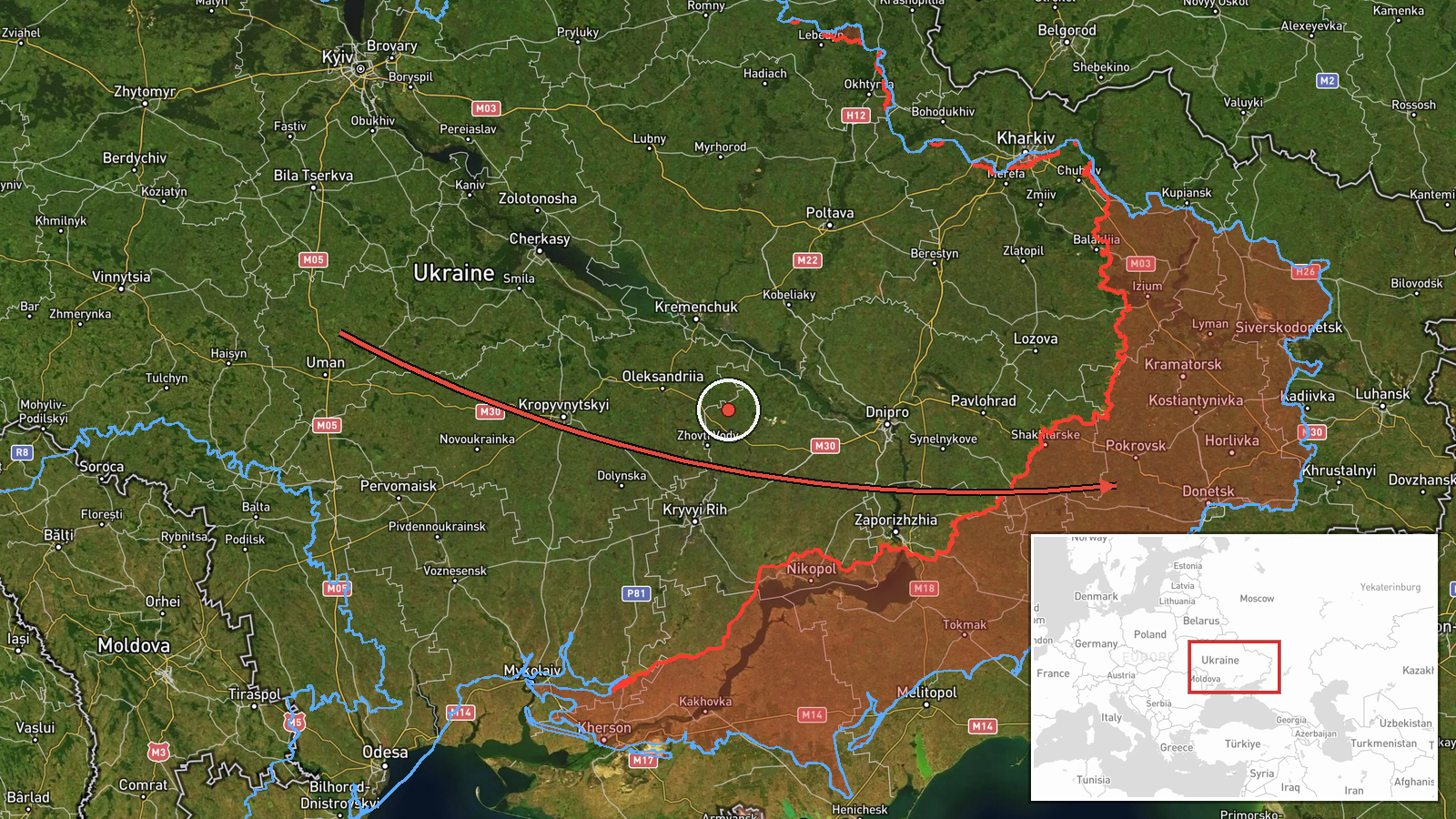
Ukrainian air monitoring channel @kpszsu reported one Russian jet-powered Shahed, designated Geran-3, moving toward Kalynivskyi in Vinnytsia Oblast. The original Ukrainian-language post, which carries a motorcycle emoji as a marker, describes a jet drone approaching Kalynivka in the Vinnytsia region from the east. The summary field frames the track as coming from Vinnytsia Oblast toward the settlement. The alert is timestamped 16 October 2026 at 03:49 UTC. The report describes a transit rather than an impact, and no strike, casualties, or damage are mentioned in the source text. The alert is a single-channel report and has not been independently matched by another outlet in the data provided.
Context and assessment
The alert sits within a dense run of drone activity around Kalynivskyi over roughly 16 hours. Earlier on 15 October, a drone was reported moving from Vinnytsia Oblast toward the settlement at 09:18 UTC, and another was reported over Kalynivskyi at 18:30 UTC. A drone passed Lazurnyi heading west at 07:24 UTC the same day, which suggests a corridor of westbound or transit traffic through the region. The same period also shows activity further east: a Ukrainian strike on a Russian storage, preparation and launch site for attack drones in Donetsk Oblast was reported at 13:03 UTC on 15 October, and a guided glide bomb was reported heading toward Donetsk Oblast at 01:04 UTC on 16 October. Taken together, these reports may indicate Russian long-range drone flights routed across central and western Ukraine, but a transit alert alone does not establish a target or intent. Repeated sightings near the same settlement could reflect routing, a decoy pattern, or simply the flight path toward other areas, and the data does not confirm which.
Sources and confidence
The only source listed is the Telegram channel @kpszsu, which carries Ukrainian air monitoring alerts and is a recurring source for drone tracking in this dataset. No second outlet, official statement, or imagery is attached to this entry. The confidence score of 8.0 reflects a direct, specific report from an established monitoring channel, tempered by the single-source status and the lack of follow-up confirmation. The confidence would rise if another monitoring source or a regional military administration confirmed the track, or if wreckage or impact reporting followed. It would fall if the channel corrected the direction or location, or if the track was later attributed to a different area.
Location
The event is tagged to Kalynivskyi, Ukraine, at settlement-level precision, with the location confidence rated high. The coordinates, however, place the point near 48.007 N, 37.854 E, which falls in eastern Ukraine in the Donetsk region, rather than in Kalynivka in Vinnytsia Oblast named in the report. This discrepancy is unresolved in the data and should be treated as a flag on the placement. The Donetsk area is a frontline zone with heavy drone traffic, while Vinnytsia lies far to the west, so the mapped point and the reported location may refer to different settlements sharing a name.
Related events nearby
- Ukrainian air monitoring: 1 Russian jet-powered Shahed (Geran-3) drone over Kalynivskyi.2026-10-15 18:30 UTC · Drone Transit · Kalynivskyi, Ukraine
- Ukrainian air monitoring: 1 Russian jet-powered Shahed (Geran-3) drone from Vinnytsia Oblast toward Kalynivsky2026-10-15 09:18 UTC · Drone Transit · Kalynivskyi, Ukraine
- Ukrainian forces struck a Russian storage, preparation, and launch site for attack drones in Donetsk region. E2026-10-15 13:03 UTC · UAS Strike · Donetsk Oblast, Ukraine
- Ukrainian air monitoring: 1 Russian guided glide bomb (KAB) heading toward Donetsk Oblast.2026-10-16 01:04 UTC · Airstrike · Donetsk Oblast, Ukraine
- Ukrainian air monitoring: 1 Russian jet-powered Shahed (Geran-3) drone passing Lazurnyi, heading west.2026-10-15 07:24 UTC · Drone Transit · Lazurnyi, Ukraine
▶ View this event on the live map

Intel Mapper aggregates open-source reports from monitored Telegram and X channels, geolocates them, cross-checks duplicates across sources and assigns a confidence score. Entries are updated as new confirmations arrive. Read how we verify events.