Ukrainian Air Force reports 3+ Shahed-type drones tracked from northern Chernihiv Oblast toward Slavutych
What happened
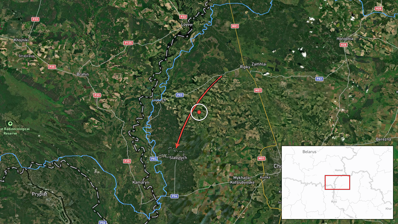
Ukraine's Air Force, posting through its official Telegram channel @kpszsu, said at about 10:40 UTC on 16 October 2026 that new groups of unmanned aerial vehicles were moving across northern Chernihiv Oblast on a course toward Slavutych. The Ukrainian-language post describes the drones as Shahed-type, with a count of three or more. The wording 'new groups' suggests a fresh wave rather than a continuation of an earlier track, though the post gives no altitude, speed, or outcome. No impact, damage, or casualties are reported in the source. The event is classed as a drone transit, meaning the aircraft were tracked on approach rather than confirmed as striking the city. Because the report rests on a single channel post, the details depend on that alert alone.
Context and assessment
Slavutych is a planned city built after the 1986 Chornobyl disaster to house workers and displaced families, and it lies near the Chornobyl exclusion zone and the Belarus border. That makes it a notable settlement but not an obvious military target, which is why its appearance in a track is worth noting. The related events show a sustained pattern in the same area. Earlier on 16 October, a single jet-powered Geran-3 was tracked from northern Chernihiv Oblast toward Slavutych at 06:54 UTC. Around the same time, a Banderol mini cruise missile was reported from southern Chernihiv Oblast toward Kozelets at 05:53 UTC. Drone groups were also reported over or heading toward Chernihiv city on 15 October and again at 10:21 UTC on 16 October. Taken together, this suggests repeated launches moving through the Chernihiv corridor over roughly a day, with the drones routed through the region rather than fixed on a single point. Operationally, such patterns may indicate attempts to route aircraft toward targets further south or east, to saturate air defences across several districts, or to draw defensive responses away from other axes. These readings remain inference, since the alerts do not identify intended targets.
Sources and confidence
The report comes from Telegram channel @kpszsu, the official Ukrainian Air Force account that typically issues primary alerts on air movements. The dataset contains no independent cross-confirmation, and the source count is one. The related events come from the same type of air monitoring and are consistent in pattern, but they do not independently verify this specific track. The confidence score of 8.0 reflects the official origin and the specific settlement named, offset by the single-source basis and the absence of any reported outcome. Confidence would rise with independent reporting, air-defence statements, or confirmation of impacts. It would fall if the alert were corrected or withdrawn, or if contradicting monitoring reports appeared.
Location
The coordinates, 51.5225 N and 30.71806 E, are settlement-level and assigned to the town of Slavutych, with high location confidence because the report names the city directly. Slavutych is a planned city in northeastern Ukraine. Officially it lies in Kyiv Oblast, not Chernihiv Oblast, so the Chernihiv reference describes the drones' approach rather than the target's administrative location. The surrounding terrain is largely flat, with forest and farmland typical of the Polissia lowlands.
Related events nearby
- Ukrainian air monitoring: 1 Russian jet-powered Shahed (Geran-3) drone from northern Chernihiv Oblast toward S2026-10-16 06:54 UTC · Drone Transit · Slavutych, Ukraine
- Ukrainian air monitoring: 2+ Russian jet-powered Shahed (Geran-3) drones over Chernihiv.2026-10-15 15:38 UTC · Drone Transit · Chernihiv, Ukraine
- Ukrainian air monitoring: 3+ Russian Shahed-type drones heading toward Chernihiv.2026-10-16 10:21 UTC · Drone Transit · Chernihiv, Ukraine
- Ukrainian air monitoring: 1 Russian jet-powered Shahed (Geran-3) drone heading toward Chernihiv.2026-10-15 17:08 UTC · Drone Transit · Chernihiv, Ukraine
- Ukrainian air monitoring: 1 Russian Banderol mini cruise missile from southern Chernihiv Oblast toward Kozelet2026-10-16 05:53 UTC · Cruise Missile · Kozelets, Ukraine
▶ View this event on the live map

Intel Mapper aggregates open-source reports from monitored Telegram and X channels, geolocates them, cross-checks duplicates across sources and assigns a confidence score. Entries are updated as new confirmations arrive. Read how we verify events.