Shahed-type drone reported moving from northern Chernihiv into northern Kyiv Oblast
What happened
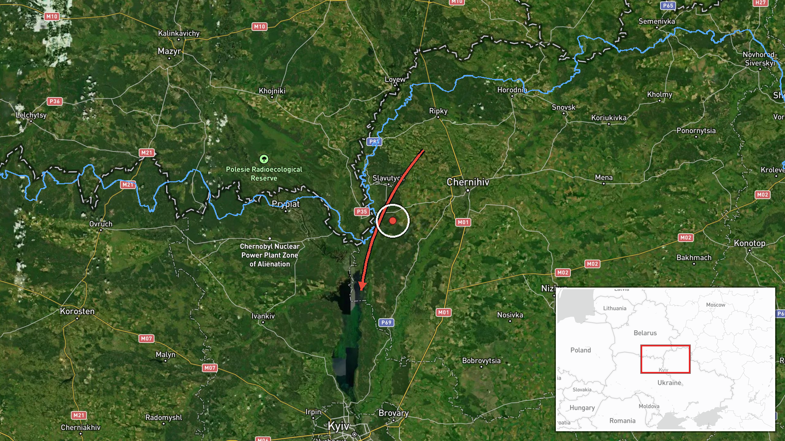
Ukrainian air monitoring reported one Russian Shahed-type drone travelling from northern Chernihiv Oblast toward northern Kyiv Oblast on 17 October 2026, with the entry logged at 06:32 UTC. The original post, written in Ukrainian as a short alert with a drone icon, reads roughly as 'UAV from the north of Chernihiv region to the north of Kyiv region.' The wording describes a transit rather than a strike, and the report does not mention impact, damage, or casualties. The event was published through a single Telegram channel, @kpszsu, and the attribution to Russia and the drone type come from that same alert. The report gives no specific settlement, so the map marker reflects the wider northern Kyiv Oblast area rather than a pinpointed site.
Context and assessment
This report belongs to a cluster of five Drone Transit alerts logged between 00:28 and 04:26 UTC on the same date. Earlier reports describe jet-powered Shahed (Geran-3) drones leaving Chernihiv Oblast toward the Vyshhorod district, Oster, and Honcharivske, while a Shahed-type drone was reported over Moshchun and later passing northern Kyiv Oblast heading west. Taken together, the sequence shows repeated use of a northern corridor that runs from Chernihiv across the approaches to Kyiv. Because the alerts track movement rather than impact, they suggest that drones were being routed through or around the Kyiv area instead of hitting a fixed target in the region. Such a pattern may indicate efforts to stretch air defence coverage, to probe reaction times, or to reach targets further west along the same line. These readings are inferences from track data alone, and the later, lower-resolution alert gives no sign of intent beyond the transit itself.
Sources and confidence
The event rests on one Telegram channel, @kpszsu, and no independent outlet in the data confirms it. The score of 8.0 reflects a consistent alert format, a clear direction of travel, and a set of related transit reports on the same night that point the same way. It is held below the top range because the report is single-source and the location is approximate. Confidence would rise if other monitoring channels, local officials, or wire services independently described the same track, or if the flight path appeared in regional reporting. It would fall if later updates revised the direction, the drone count, or the timing, or if the track were shown to belong to a different aircraft.
Location
The location is recorded at region precision with low location confidence. The coordinates, roughly 50.995 N and 30.520 E, sit near the centre of northern Kyiv Oblast and do not mark a settlement or facility. The area is largely flat, drained by the Dnipro basin, and includes forest, farmland, and wetland stretches near the Chernihiv border to the north. The marker should be read as a general zone for the drone's path rather than a precise point.
Related events nearby
- Ukrainian air monitoring: 2+ Russian Shahed-type drones from Belarus toward northern Kyiv Oblast.2026-10-17 07:40 UTC · Drone Transit · northern Kyiv Oblast, Ukraine
- Ukrainian air monitoring: 1 Russian Shahed-type drone passing northern Kyiv Oblast, heading west.2026-10-17 04:26 UTC · Drone Transit · northern Kyiv Oblast, Ukraine
- Ukrainian air monitoring: 1 Russian jet-powered Shahed (Geran-3) drone from western Chernihiv Oblast toward Os2026-10-17 01:23 UTC · Drone Transit · Oster, Ukraine
- Ukrainian air monitoring: 1 Russian jet-powered Shahed (Geran-3) drone heading toward Honcharivske.2026-10-17 03:36 UTC · Drone Transit · Honcharivske, Ukraine
- Ukrainian air monitoring: 1 Russian Shahed-type drone over Moshchun.2026-10-17 04:25 UTC · Drone Transit · Moshchun, Ukraine
▶ View this event on the live map

Intel Mapper aggregates open-source reports from monitored Telegram and X channels, geolocates them, cross-checks duplicates across sources and assigns a confidence score. Entries are updated as new confirmations arrive. Read how we verify events.