Air monitoring reports 2+ jet-powered Shahed drones from Chernihiv Oblast toward Kyiv Oblast
What happened
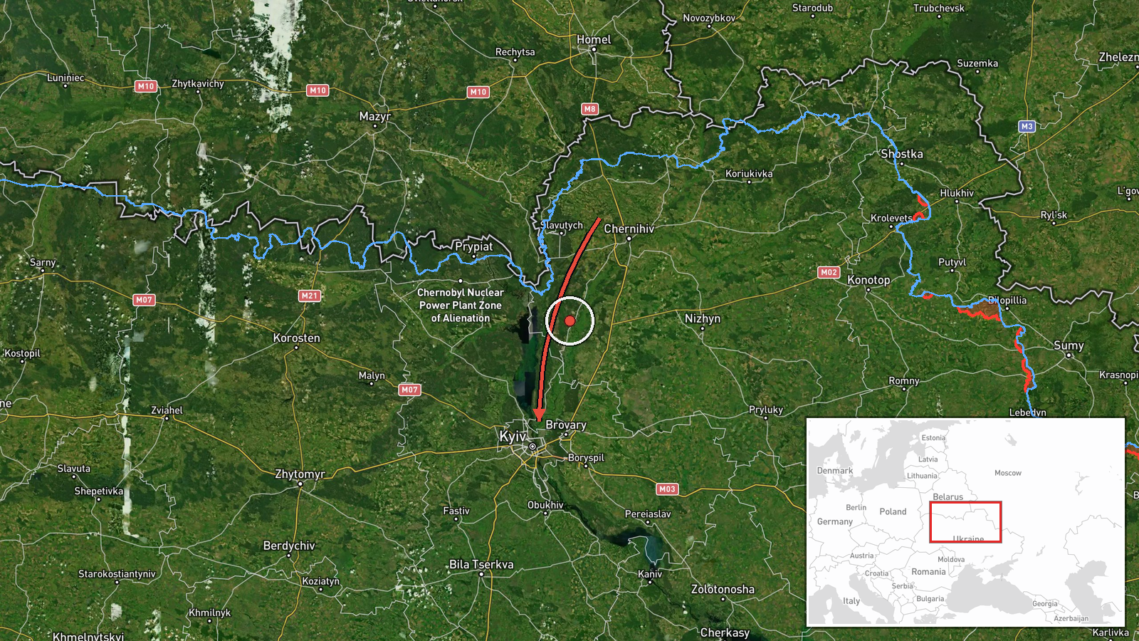
A Ukrainian air monitoring report posted to the Telegram channel @kpszsu on 17 October 2026 at 09:45 UTC describes a new group of jet-powered unmanned aerial vehicles in northern Chernihiv Oblast. The original Ukrainian wording describes a course running along the border with Belarus in the direction of Kyiv Oblast. The English summary records at least two Russian jet-powered Shahed (Geran-3) drones. The report names no impact site, no casualties, and no interception. It describes movement only, not a strike, and it places the activity at the level of the broad oblast rather than a specific settlement.
Context and assessment
This report is one of several short transit reports logged within about fourteen hours. Earlier that night, a Geran-3 was reported passing Drabiv toward Kyiv Oblast, and in the early hours a group of three or more Shahed-type drones was reported from western Chernihiv Oblast toward Kyiv Oblast, with one passing the Vyshhorod district. Later reports cover single drones heading toward Kyiv, including one Geran-3 passing Hlevakha and heading west, and another from Belarus toward Kyiv Oblast. The pattern is a repeated, low-volume flow along the northern corridor toward the capital region rather than one isolated sighting. Kyiv is the country's political and administrative center and the surrounding oblast hosts substantial infrastructure, so sustained transit reports of this kind usually draw close attention from air defense units. Operationally, the routing along the Chernihiv and Belarus border corridor is consistent with approaches that use northern terrain and airspace to reach the capital area. Repeated waves can be intended to stretch air defense coverage, to probe response times, or simply to reflect a continuing campaign. The available data cannot establish which of these applies. The jet-powered variant is generally described as faster than piston-engined Shahed models, which would shorten warning times, but this report does not give speed or altitude.
Sources and confidence
All information comes from one channel, Telegram @kpszsu, which is generally associated with the Ukrainian Air Force. No independent outlet in the data corroborates the report, so the account rests on a single source. The confidence score of 8.0 reflects the channel's official character, the detail in the original wording, and consistency with the earlier transit reports on the same morning. It is not higher because the report is unconfirmed by any second source and does not record a crossing, impact, or interception. Confidence would rise with corroboration from other monitoring channels or from reports of drones detected or downed in the named areas. It would fall if the channel issues a correction, if later air alerts contradict the routing, or if further reporting shows the drones were tracked elsewhere.
Location
The location is recorded as Kyiv Oblast at region precision with low location confidence. The listed coordinates, 50.45 and 30.52, fall in central Kyiv, so they are a placeholder for the oblast rather than a tracked position of the drones. The area is part of the Dnipro lowland, with the Dnipro River to the east and Polissia forests and marshes to the north. Chernihiv Oblast lies to the north along the Belarusian border.
Related events nearby
- Ukrainian air monitoring: 1 Russian Shahed-type drone from Belarus toward Kyiv Oblast.2026-10-17 06:39 UTC · Drone Transit · Kyiv Oblast, Ukraine
- Ukrainian air monitoring: 1 Russian Shahed-type drone heading toward Kyiv; 1 Russian jet-powered Shahed (Geran2026-10-17 04:07 UTC · Drone Transit · Kyiv, Ukraine
- Ukrainian air monitoring: 3+ Russian Shahed-type drones from western Chernihiv Oblast toward Kyiv Oblast; 1 Ru2026-10-17 03:59 UTC · Drone Transit · Kyiv Oblast, Ukraine
- Ukrainian air monitoring: 1 Russian Shahed-type drone heading toward Kyiv.2026-10-17 01:36 UTC · Drone Transit · Kyiv, Ukraine
- Ukrainian air monitoring: 1 Russian jet-powered Shahed (Geran-3) drone passing Drabiv, heading toward Kyiv Obl2026-10-16 20:18 UTC · Drone Transit · Kyiv Oblast, Ukraine
▶ View this event on the live map

Intel Mapper aggregates open-source reports from monitored Telegram and X channels, geolocates them, cross-checks duplicates across sources and assigns a confidence score. Entries are updated as new confirmations arrive. Read how we verify events.