Russian Shahed-type drone reported passing Bashtanka toward Nova Odesa, Mykolaiv Oblast
What happened
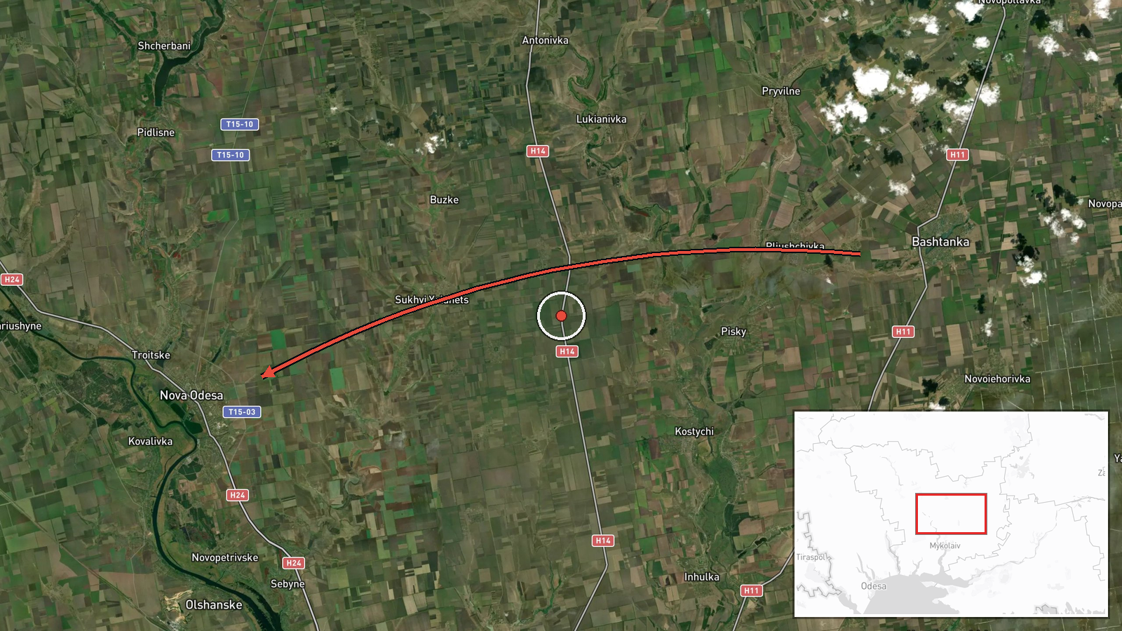
Ukrainian air monitoring reported one Shahed-type drone, attributed to Russia, passing Bashtanka on 17 October 2026 at about 12:09 UTC. The original Ukrainian-language post, published by the Telegram channel @kpszsu, describes the unmanned aerial vehicle moving in a northwest direction past Bashtanka and heading toward Nova Odesa from the east. The wording indicates the drone was in transit rather than striking a target, and the report contains no information about damage, casualties, or impact. The event is recorded as a single-source report with a confidence score of 8.0 out of 10, and the location is pinned to the Nova Odesa settlement.
Context and assessment
Bashtanka and Nova Odesa both sit in northern Mykolaiv Oblast, a corridor that has seen repeated drone traffic in recent days. The related reports form a visible sequence. On 16 October at 14:34 UTC, a Shahed-type drone was logged moving from Kherson Oblast toward Mykolaiv Oblast. About twenty hours later, on 17 October, separate Ukrainian air monitoring posts tracked a drone passing the Bashtanka district heading west at 11:08, then heading toward Bashtanka at 11:13, and this Nova Odesa report followed roughly an hour after that. Earlier on 17 October at 07:39, a jet-powered Shahed variant described as Geran-3 passed Mykolaiv Oblast heading northwest. Taken together, the pattern suggests repeated northwest-bound routing across the oblast, which may indicate drones being directed toward targets further inland or along transit corridors rather than isolated strikes. Transit reports of this kind typically serve an early-warning function, allowing air defense and civil authorities to respond. A Telegram report from the previous afternoon of trucks set ablaze on the M-14 Novorossiya highway is unconfirmed, and it should not be linked to these drones without corroboration.
Sources and confidence
The report rests on a single Telegram channel, @kpszsu, which is an official Ukrainian air-monitoring account, and no second outlet is listed in the data. The confidence score of 8.0 reflects the channel's established role in airspace reporting and the specificity of the time, direction, and settlement references, offset by the absence of independent cross-confirmation. Confidence would rise with corroboration from regional military administration statements, radar-based reports, or subsequent debris or impact reports from Nova Odesa. It would fall if later updates revised the drone's track or if other monitoring sources did not record the transit.
Location
The point is pinned to Nova Odesa at the settlement level with high location confidence, so the marker reflects the town rather than a precise site. Nova Odesa lies in northern Mykolaiv Oblast on the steppe of southern Ukraine, where open agricultural land and river valleys of the Southern Bug basin dominate the terrain. Bashtanka, the other named reference point, is another town in the same oblast, and the reported flight path crosses this low-relief farmland.
Related events nearby
- Ukrainian air monitoring: 1 Russian jet-powered Shahed (Geran-3) drone passing Mykolaiv Oblast, heading northw2026-10-17 07:39 UTC · Drone Transit · Mykolaiv Oblast, Ukraine
- Ukrainian air monitoring: 1 Russian Shahed-type drone from Kherson Oblast toward Mykolaiv Oblast.2026-10-16 14:34 UTC · Drone Transit · Mykolaiv Oblast, Ukraine
- Ukrainian air monitoring: 1 Russian Shahed-type drone heading toward Bashtanka.2026-10-17 11:13 UTC · Drone Transit · Bashtanka, Ukraine
- Ukrainian air monitoring: 1 Russian Shahed-type drone passing Bashtanka district, heading west.2026-10-17 11:08 UTC · Drone Transit · Bashtanka district, Ukraine
- Ukrainian air monitoring: 1 Russian Shahed-type drone from Odesa Oblast toward Berezivka.2026-10-17 12:44 UTC · Drone Transit · Berezivka, Ukraine
▶ View this event on the live map

Intel Mapper aggregates open-source reports from monitored Telegram and X channels, geolocates them, cross-checks duplicates across sources and assigns a confidence score. Entries are updated as new confirmations arrive. Read how we verify events.