Ukrainian air monitoring reports one Shahed-type drone heading toward Esman, Sumy Oblast
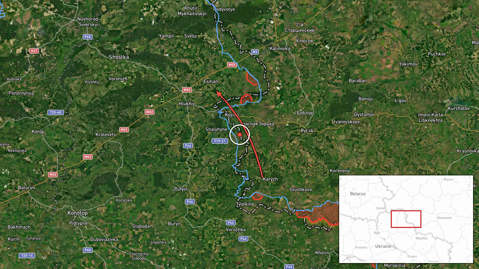
What happened
On 17 October 2026, at about 15:21 UTC, Ukrainian air monitoring reported one Russian Shahed-type drone moving toward the settlement of Esman in Sumy Oblast, northern Ukraine. The alert was posted on the Telegram channel @kpszsu, which carries Ukrainian air monitoring updates. The original Ukrainian wording describes a UAV heading to Esman in the Sumy region from the northeast, which indicates a direction of approach rather than a confirmed impact. The report does not mention a strike, damage, casualties, or interception, and no other channel has independently repeated it. The event is classified as a drone transit rather than a completed attack.
Context and assessment
Esman lies in the northern part of Sumy Oblast, close to the Russian border, and the area has seen a steady run of activity on this date. Earlier on 17 October, air monitoring logged a drone heading toward Hlukhiv from northern Sumy Oblast, and a later alert described a single Shahed-type drone toward Novhorod-Siverskyi. Around the same time, the Ukrainian General Staff reported eleven combat clashes on the North Slobozhansky axis by late on 16 October, including near Tovstodubove, and Russian artillery shelled nine Sumy Oblast settlements on the morning of 17 October. Taken together, the drone tracks suggest a sequence of single or small-group drone movements across several border settlements rather than one concentrated raid. Such patterns are often consistent with reconnaissance, probing of air defence coverage, or attempts to strike infrastructure, but the data alone does not establish intent. The Ukrainian strike on a railway bridge in Bryansk Oblast, reported separately that morning, shows the wider cross-border exchange, though it is not directly tied to this drone.
Sources and confidence
The event rests on a single Telegram channel, @kpszsu, which is the only source recorded. Its wording is a short air-monitoring alert rather than an assessment of damage, so the report is best read as a warning of an inbound drone. The confidence score of 8.0 reflects a clear, specific alert with a precise settlement name and timestamp, offset by the lack of independent confirmation. Confidence would rise if regional officials, local authorities, or a second monitoring source reported the same track or any impact. It would fall if later updates showed the drone was diverted, shot down elsewhere, or that the alert referred to a different settlement.
Location
The location is placed at the settlement level, as Esman, Ukraine, with coordinates of approximately 51.770 N and 34.065 E. The precision is recorded as settlement, and the location confidence is high because the town name appears directly in the source wording. Esman sits in northern Sumy Oblast, near the Russian frontier and within the broader North Slobozhansky area. The surrounding terrain is largely flat agricultural land with river valleys and scattered forest belts. The point should be treated as the town centre for mapping purposes, not as an exact target or the location of any particular facility.
Related events nearby
- Ukrainian air monitoring: 2+ Russian Shahed-type drones from northern Sumy Oblast toward Hlukhiv.2026-10-17 06:46 UTC · Drone Transit · Hlukhiv, Ukraine
- Ukrainian General Staff reports 11 combat clashes on the North Slobozhansky axis by 22:00, including near Tovs2026-10-16 19:01 UTC · Combat · Tovstodubove, Sumy Oblast, Ukraine
- Russian artillery shelled nine Sumy Oblast settlements, per Ukrainian General Staff; a Russian aviation strike2026-10-17 05:05 UTC · Artillery · Ulanove, Sumy Oblast, Ukraine
- Ukrainian air monitoring: 1 Russian Shahed-type drone heading toward Novhorod-Siverskyi.2026-10-17 14:06 UTC · Drone Transit · Novhorod-Siverskyi, Ukraine
- Ukrainian Defense Forces struck a railway bridge over the Unecha River near Sloboda-Seletska, Bryansk Oblast, 2026-10-17 09:27 UTC · Combat · Russia border area (location not reported)
▶ View this event on the live map

Intel Mapper aggregates open-source reports from monitored Telegram and X channels, geolocates them, cross-checks duplicates across sources and assigns a confidence score. Entries are updated as new confirmations arrive. Read how we verify events.