Ukrainian air monitoring reports one Shahed-type drone heading west over the Kyiv Reservoir area
What happened
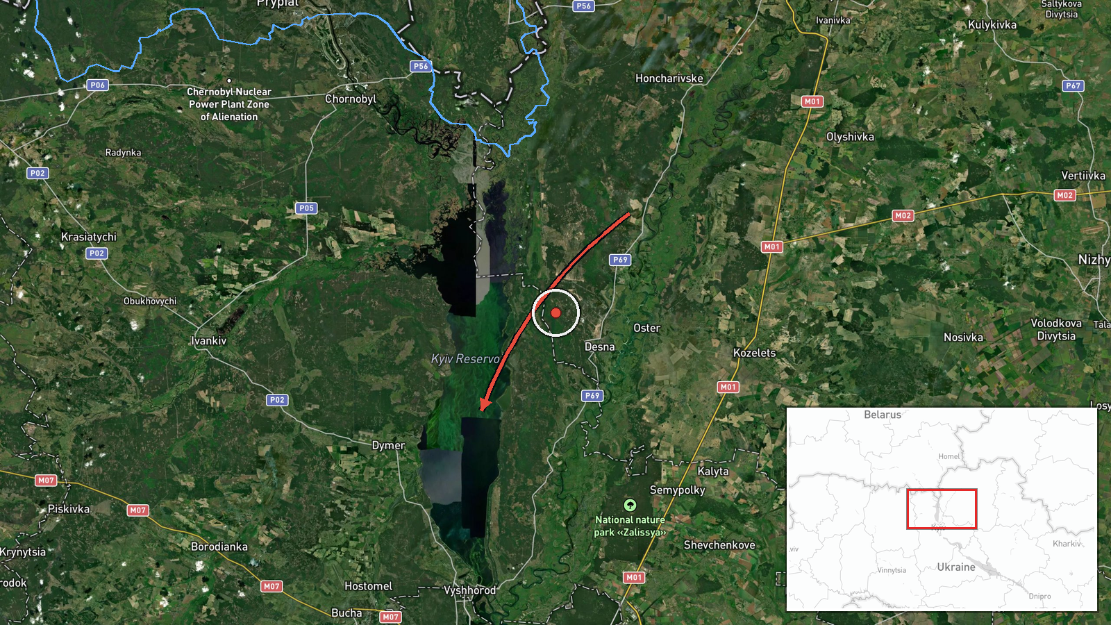
Ukrainian air monitoring reported one Russian Shahed-type drone moving from Chernihiv Oblast toward the Kyiv Reservoir on a westward course. The original Ukrainian-language post describes it as a strike UAV, and the English summary classifies it as Shahed-type. The report was published at 02:04 UTC on 18 October 2026 by the Telegram channel @kpszsu, the public feed associated with Ukraine's Air Force monitoring. The post names no impact, casualties, or damage, and it identifies no specific target beyond the reservoir area. The event is logged as a drone transit, which means it tracks movement through airspace rather than a confirmed strike.
Context and assessment
The reservoir sits north of the capital along the Dnipro, so a drone tracking toward it falls within the approaches to Kyiv and its surrounding infrastructure. The related events show a dense run of drone transits over northern Kyiv Oblast on 17 October, beginning at 04:26 UTC and continuing through the day. Those reports include Shahed-type drones coming from northern Chernihiv Oblast, a group of two or more drones reported as coming from Belarus, and one jet-powered Shahed variant described as a Geran-3. The repeated entries from the same corridor suggest a sustained pattern of routing through the north of the region rather than isolated sightings. Because the reports describe transit and heading rather than detonations, they indicate movement that monitoring teams are tracking, not a known objective. A drone heading west after passing the reservoir area could be following a route toward other targets further west, or it could be a decoy or a path adjustment, but the data alone cannot confirm which. The pattern is best read as ongoing aerial pressure on the Kyiv approaches.
Sources and confidence
Only one channel reported this event, the Telegram account @kpszsu, and no independent outlet or second monitoring source appears in the data. The channel is an official-style feed tied to Ukrainian air monitoring, which supports a confidence score of 8.0, but a single-channel report cannot reach the top of the scale. Confidence would rise with a corroborating post from another monitoring body, regional military administration, or an independent tracker showing the same track. It would fall if later updates contradicted the drone type, heading, or origin, or if no matching reports appeared for the same window.
Location
The location is recorded at settlement precision as Kyiv Reservoir, with coordinates of 50.8 north and 30.47 east, and location confidence is rated high. The reservoir is a large body of water formed by a dam on the Dnipro, lying north of Kyiv and extending into the surrounding Kyiv Oblast. The coordinates are a broad reference point rather than an exact position for the drone. The reservoir's shoreline, dam, and nearby towns are the main landmarks for the area.
Related events nearby
- Ukrainian air monitoring: 1 Russian jet-powered Shahed (Geran-3) drone heading toward northern Kyiv Oblast.2026-10-17 15:24 UTC · Drone Transit · northern Kyiv Oblast, Ukraine
- Ukrainian air monitoring: 1 Russian Shahed-type drone from northern Chernihiv Oblast toward northern Kyiv Obla2026-10-17 08:45 UTC · Drone Transit · northern Kyiv Oblast, Ukraine
- Ukrainian air monitoring: 2+ Russian Shahed-type drones from Belarus toward northern Kyiv Oblast.2026-10-17 07:40 UTC · Drone Transit · northern Kyiv Oblast, Ukraine
- Ukrainian air monitoring: 1 Russian Shahed-type drone from northern Chernihiv Oblast toward northern Kyiv Obla2026-10-17 06:32 UTC · Drone Transit · northern Kyiv Oblast, Ukraine
- Ukrainian air monitoring: 1 Russian Shahed-type drone passing northern Kyiv Oblast, heading west.2026-10-17 04:26 UTC · Drone Transit · northern Kyiv Oblast, Ukraine
▶ View this event on the live map

Intel Mapper aggregates open-source reports from monitored Telegram and X channels, geolocates them, cross-checks duplicates across sources and assigns a confidence score. Entries are updated as new confirmations arrive. Read how we verify events.