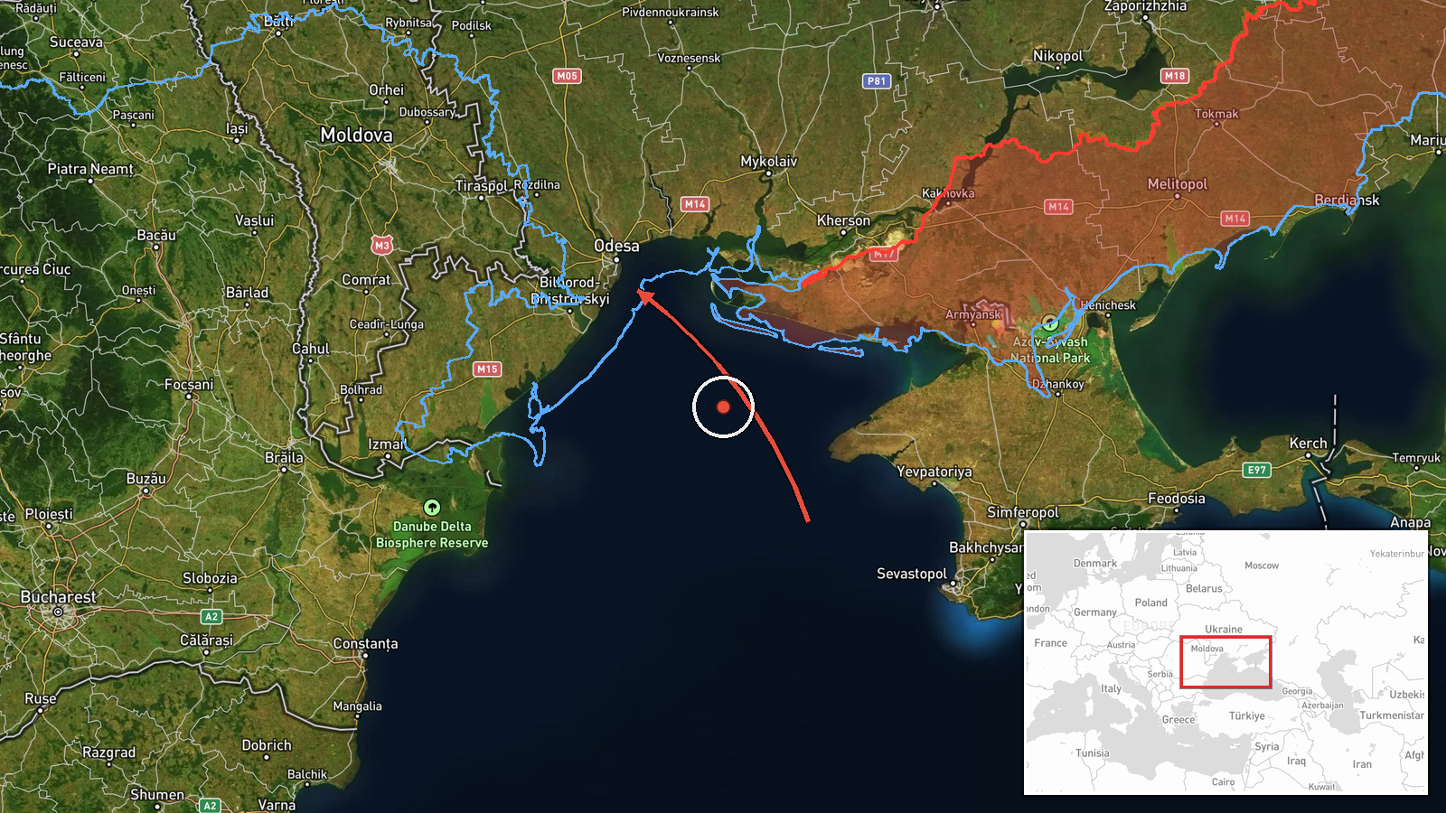
Single Shahed-type drone tracked from Black Sea toward Odesa Oblast, Ukraine
What happened
Ukrainian air monitoring reportedly tracked one Russian Shahed-type drone moving from the Black Sea toward Odesa Oblast at about 05:53 UTC on 18 October 2026. The original Ukrainian-language post, published on the Telegram channel @kpszsu, describes an unmanned aerial vehicle on a course toward the Odesa region. It names no settlement, target, or impact. The report is a transit notice rather than a strike report, so it establishes that a drone was tracked but not where it ended up or whether it caused damage. The post attributes the drone to Russia by type, not by any claimed launch, and describes no casualties or damage.
Context and assessment
Odesa is a major Black Sea port and one of the most frequently targeted areas of southern Ukraine, and attacks there have repeatedly been aimed at port infrastructure, energy assets, and logistics. The event sits within a dense cluster of drone transits in the surrounding southern oblasts. Over roughly 36 hours, related reports describe Shahed-type drones moving from the Black Sea toward southern Mykolaiv Oblast, passing Mykolaiv Oblast heading northwest, tracking from Kherson Oblast toward Mykolaiv, moving from Odesa Oblast toward Berezivka, and crossing the Odesa-Mykolaiv border heading north. Several of these reports specify jet-powered Geran-3 variants, while others describe piston-type Shahed drones, which suggests a mixed package of platforms. The pattern of repeated single-drone tracks along the same coastal corridor may indicate sustained launches, routing across several oblasts, or probing of air-defense coverage. A single track alone does not show intent, and the wider sequence is more informative than this one report.
Sources and confidence
The event rests on one Telegram channel, @kpszsu, which is listed as the sole source. No independent outlet, radar feed, or second official channel has been found to confirm this specific track. The confidence score of 8.0 reflects that the channel is an official Ukrainian air monitoring account whose drone-transit notices are consistent with the related reports for the same period. It is held below the top of the scale because the post is single-sourced and gives no impact outcome. Confidence would rise with corroboration from other monitoring channels, wire services, or local officials describing the same track or an impact. It would fall if the channel corrected or retracted the notice, or if later tracking placed the drone elsewhere.
Location
The location is an oblast-level approximation, not a settlement or facility. The post names only Odesa Oblast, so the coordinates (46.48, 30.73) mark a point within the region rather than a confirmed position. Odesa Oblast lies on Ukraine's northwestern Black Sea coast, with the port city of Odesa on the shoreline, the Danube delta to the southwest, and the Dniester estuary to the west. Its eastern boundary adjoins Mykolaiv Oblast. The low location confidence reflects that the drone's actual position is unknown.
Related events nearby
- Ukrainian air monitoring: jet-powered Shahed (Geran-3) drones tracked at the Odesa-Mykolaiv border, heading no2026-10-18 02:47 UTC · Drone Transit · Odesa-Mykolaiv Oblast border, Ukraine
- Ukrainian air monitoring: 1 Russian Shahed-type drone from Black Sea toward southern Odesa Oblast.2026-10-18 06:55 UTC · Drone Transit · southern Odesa Oblast, Ukraine
- Ukrainian air monitoring: 1 Russian Shahed-type drone from Odesa Oblast toward Berezivka.2026-10-17 12:44 UTC · Drone Transit · Berezivka, Ukraine
- Ukrainian air monitoring: 1 Russian Shahed-type drone from Black Sea toward southern Mykolaiv Oblast.2026-10-17 07:29 UTC · Drone Transit · southern Mykolaiv Oblast, Ukraine
- Ukrainian air monitoring: 1 Russian jet-powered Shahed (Geran-3) drone from Kherson Oblast toward Mykolaiv Obl2026-10-18 02:05 UTC · Drone Transit · Mykolaiv Oblast, Ukraine
▶ View this event on the live map

Intel Mapper aggregates open-source reports from monitored Telegram and X channels, geolocates them, cross-checks duplicates across sources and assigns a confidence score. Entries are updated as new confirmations arrive. Read how we verify events.