Ukraine reports Russian Banderol cruise missile heading west toward Chernihiv Oblast
What happened
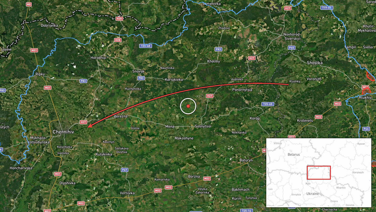
Ukrainian air monitoring reported at about 07:45 UTC on 18 October 2026 that one Russian Banderol mini cruise missile was passing the Russian city of Voronezh on a westward course toward Chernihiv Oblast in northern Ukraine. The alert was posted on Telegram by the Ukrainian Air Force monitoring channel @kpszsu, which is the only source listed for this entry. The original Ukrainian post, headed with the Sumy region label, says the missile is flying 'on course to the west (Chernihiv region).' The report does not mention impact, interception, or damage. About fourteen minutes later, a related alert from the same stream placed a Banderol passing Berezna and heading toward Chernihiv city. The wording describes a transit track, not a confirmed strike.
Context and assessment
Chernihiv Oblast lies in northern Ukraine along the borders with Russia and Belarus, and its cities sit on routes that Russian long-range weapons have repeatedly used when approaching Kyiv and the north. The related events show a sustained pattern. Between 12:10 and 14:59 UTC on 17 October, monitoring alerts logged several Shahed-type drones heading toward Chernihiv or over the oblast, including a jet-powered Geran-3 variant at 13:48 UTC. The cruise missile alert followed the next morning, which suggests a sequence of drone and missile transits over the same corridor within roughly 24 hours. Operationally, mixing slower drones with faster cruise missiles in one period may be intended to stress air defenses or to probe several approach paths, although the data does not identify any intended target. Monitoring alerts record flight direction rather than aim point, so the purpose of each track remains unknown.
Sources and confidence
Only one channel reported this event, the Telegram account @kpszsu, which is the official monitoring feed of the Ukrainian Air Force. Its confidence score of 8.0 reflects that official origin and the consistency of related alerts from the same stream, but there is no independent cross-confirmation from regional authorities, wire services, or local media, and the entry is not marked as corrected. Confidence would rise with official statements from Chernihiv regional administration, reports of debris or impact, or matching reports from other monitoring sources. It would fall if the alert were retracted, if later updates contradicted the track, or if the missile could not be linked to the reported locations.
Location
The location is recorded at region level with low confidence. The coordinates 51.49 N, 31.29 E match the city of Chernihiv, so the marker shows the city center rather than a verified track position or a specific facility. Chernihiv Oblast is in northern Ukraine, bordered by Belarus and Russia, with wooded and marshy terrain in the north and the Desna River basin running through the region.
Related events nearby
- Ukrainian air monitoring: 1 Russian Banderol mini cruise missile passing Berezna, heading toward Chernihiv.2026-10-18 07:58 UTC · Cruise Missile · Chernihiv, Ukraine
- Ukrainian air monitoring: 2+ Russian Shahed-type drones over Chernihiv Oblast.2026-10-17 14:59 UTC · Drone Transit · Chernihiv Oblast, Ukraine
- Ukrainian air monitoring: 1 Russian jet-powered Shahed (Geran-3) drone heading toward Chernihiv.2026-10-17 13:48 UTC · Drone Transit · Chernihiv, Ukraine
- Ukrainian air monitoring: 1 Russian Shahed-type drone heading toward Chernihiv.2026-10-17 12:16 UTC · Drone Transit · Chernihiv, Ukraine
- Ukrainian air monitoring: 1 Russian Shahed-type drone heading toward Chernihiv.2026-10-17 12:10 UTC · Drone Transit · Chernihiv, Ukraine
▶ View this event on the live map

Intel Mapper aggregates open-source reports from monitored Telegram and X channels, geolocates them, cross-checks duplicates across sources and assigns a confidence score. Entries are updated as new confirmations arrive. Read how we verify events.