Single Russian Shahed-type drone reported moving toward Pyryatyn, northern Poltava Oblast
What happened
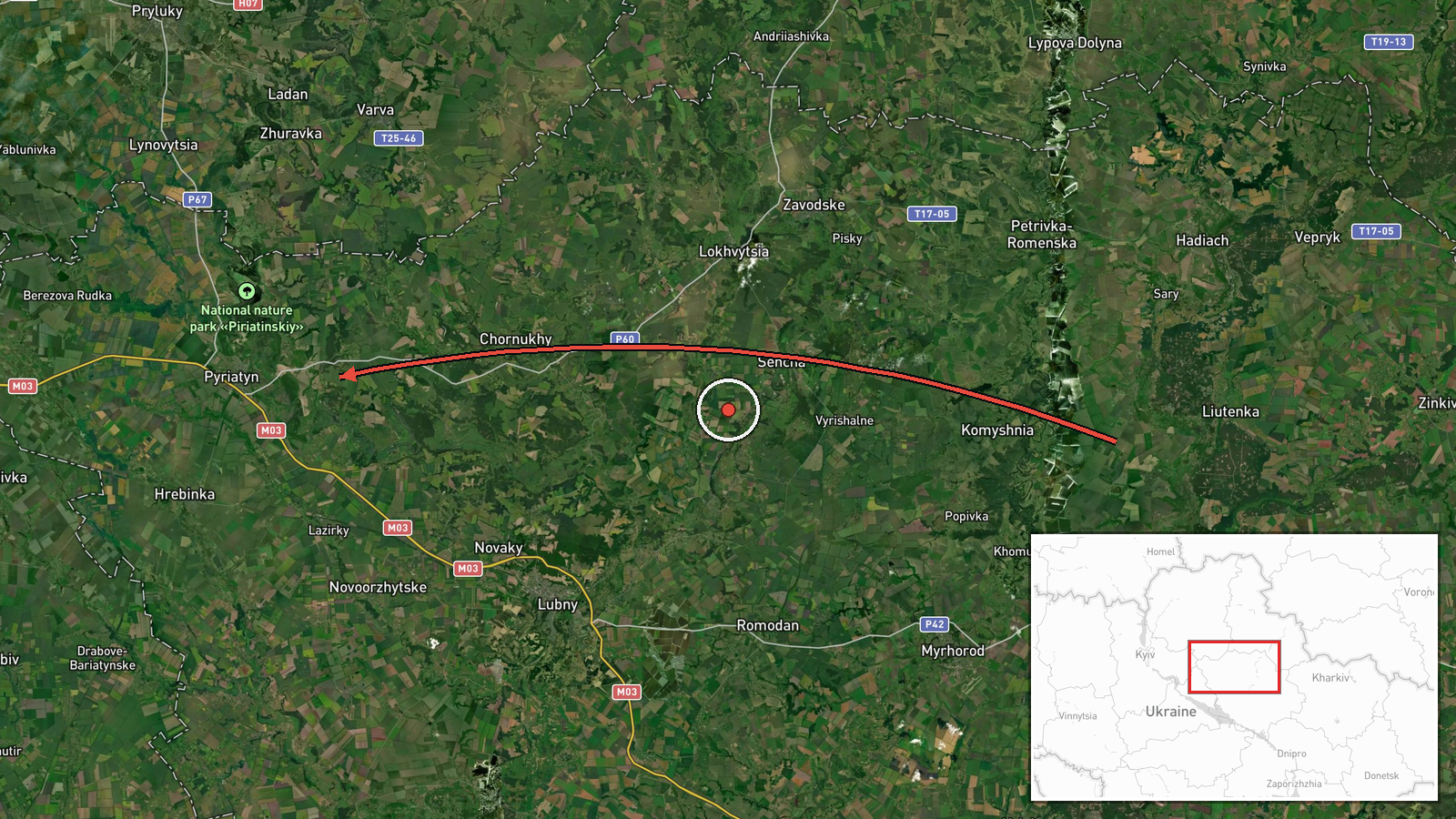
Ukrainian air monitoring reported on Telegram, through the channel @kpszsu, that one Russian Shahed-type drone was moving from northern Poltava Oblast toward Pyryatyn at about 02:41 UTC on 19 October 2026. The original Ukrainian-language post was more specific about direction, saying the drone was heading toward Pyriatyn and Chornukha in the north of Poltava region, and it used the general term BpLA for an unmanned aerial vehicle. The report describes a transit rather than a strike. It does not mention impact, damage, casualties, or the drone's final destination. Attribution to Russia reflects the channel's framing and the wider pattern of Shahed-type launches. The alert is one of several air-monitoring reports from the same overnight window.
Context and assessment
Pyryatyn sits in northern Poltava Oblast, close to the boundary with Chernihiv Oblast, so its significance in this record lies less in the town as a target than in its position along a northeastern flight path. The related events show a sequence over roughly eight hours. On the evening of 18 October, two Banderol mini cruise missiles were reported over Pryluky, after a separate missile was tracked passing Romny toward Pryluky, and another was reported passing Myrhorod toward the Zolotonosha district. Shortly after 02:40 UTC the next morning, a jet-powered Shahed, identified as a Geran-3, was tracked from Chernihiv Oblast toward Ichnia, and another was tracked north of Pryluky heading northwest. Taken together, these reports describe a multi-axis pattern across northeastern and central Ukraine. The Pyryatyn drone may be part of the same overnight wave or a separate track sharing the corridor. Operationally, a spread of tracks across several towns is consistent with an effort to stretch air defense coverage rather than hit a single point, although the data do not establish intent. Cruise missiles and jet-powered drones appearing in the same window may indicate mixed launches, which this record alone cannot confirm.
Sources and confidence
Only one channel, Telegram @kpszsu, carries this report, and the event record lists a source count of one, so no independent confirmation is in the dataset. The confidence score of 8.0 reflects a plausible official-style air monitoring post that fits several related reports from the same window. It is not higher because there is no second channel, no imagery, and no follow-up. Confidence would rise if regional authorities or independent monitors reported the same track, or if debris or impact reports appeared. It would fall if later updates revised the direction or showed the track never entered Poltava airspace.
Location
The coordinates correspond to Pyryatyn, a settlement, and the location is recorded at settlement-level precision with high location confidence. The town lies in northern Poltava Oblast, a short distance south of Pryluky in neighboring Chernihiv Oblast. The surrounding terrain is largely flat, agricultural land typical of the region, with scattered settlements, rivers, and forest belts. Such terrain offers few natural features that would hinder low-altitude drone flight.
Related events nearby
- Ukrainian air monitoring: 2 Russian Banderol mini cruise missiles over Pryluky.2026-10-18 19:34 UTC · Cruise Missile · Pryluky, Ukraine
- Ukrainian air monitoring: 1 Russian Banderol mini cruise missile passing Romny, heading toward Pryluky.2026-10-18 19:19 UTC · Cruise Missile · Pryluky, Ukraine
- Ukrainian air monitoring: one Russian jet-powered Shahed (Geran-3) drone tracked north of Pryluky, heading nor2026-10-19 02:43 UTC · Drone Transit · North of Pryluky, Chernihiv Oblast, Ukraine
- Ukrainian air monitoring: 1 Russian jet-powered Shahed (Geran-3) drone from Chernihiv Oblast toward Ichnia.2026-10-19 02:42 UTC · Drone Transit · Ichnia, Ukraine
- Ukrainian air monitoring: 1 Russian Banderol mini cruise missile passing Myrhorod, heading toward Zolotonosha 2026-10-18 19:19 UTC · Cruise Missile · Zolotonosha district, Ukraine
▶ View this event on the live map

Intel Mapper aggregates open-source reports from monitored Telegram and X channels, geolocates them, cross-checks duplicates across sources and assigns a confidence score. Entries are updated as new confirmations arrive. Read how we verify events.