Ukrainian monitors report a jet-powered Shahed drone heading toward Pereiaslav, Kyiv Oblast
What happened
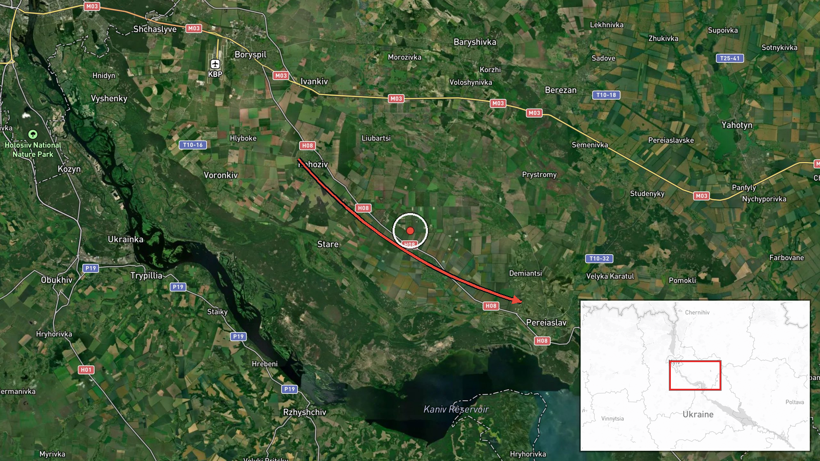
Ukrainian air monitoring reported on 19 October 2026 at 15:52 UTC that a single Russian jet-powered Shahed drone, identified as a Geran-3, was moving toward Pereiaslav in Kyiv Oblast from the south. The report was posted on the Telegram channel @kpszsu. The original Ukrainian post reads roughly as a jet-powered UAV heading to Pereiaslav in the Kyiv region from the south, and it gives no altitude, speed, or confirmed impact. The event is classed as a drone transit rather than a strike, so the record shows the object's reported movement but does not establish that it hit anything. No casualties, damage, or interception outcome appear in the data. The attribution to Russia rests on the classification of the Shahed design family rather than on independent confirmation of the launch.
Context and assessment
Pereiaslav sits on the Trubizh river roughly 80 kilometres south of Kyiv, and its position on the southern approach gives it relevance as a waypoint for drones and missiles heading into the Kyiv region. The event fits a dense pattern. On 18 October, two reports placed a Banderol mini cruise missile near Myrhorod and then over the Zolotonosha district, both in central Ukraine, suggesting several air corridors were active at once. The following morning, a large overnight attack was reported, including Iskander-M and S-400 ballistic missiles, Iskander-K cruise missiles, and 269 Shahed-type drones, and Zelensky reportedly said more than 10 energy facilities were damaged. Read together, the Pereiaslav transit may be one thread of a sustained effort to stretch air defence across several axes and keep warning systems active over populated areas, although the data does not show Pereiaslav as an intended target. Jet-powered Shahed variants are generally faster than piston-engine models, which can shorten warning time for towns near their track.
Sources and confidence
The event rests on a single Telegram channel, @kpszsu, with no second outlet or official statement cross-confirming the transit. The confidence score of 8.0 reflects a clear, specific post with a named settlement and high location confidence, offset by the single-source basis and the absence of any observed impact or follow-up. Confidence would rise if independent monitoring, local authority statements, or wire reporting corroborated the track, or if the drone's later position were recorded. It would fall if subsequent reporting reclassified the object, showed a different route, or failed to confirm the Geran-3 identification.
Location
The location was set at settlement level, with coordinates placed on the town of Pereiaslav rather than a specific facility, and the record is marked high location confidence. Pereiaslav is a small city in Kyiv Oblast on the Trubizh river, about 80 kilometres south of the capital. The surrounding terrain is largely flat agricultural land drained by river valleys, with the Dnipro lowlands to the east. The river and town road network are the main nearby features a monitor might use to describe a track.
Related events nearby
- Ukrainian air monitoring: 2+ Russian jet-powered Shahed (Geran-3) drones passing Rzhyshchiv, heading toward Ob2026-10-19 16:04 UTC · Drone Transit · Obukhiv, Ukraine
- Ukrainian air monitoring: 1 Russian Banderol mini cruise missile passing Myrhorod, heading toward Zolotonosha 2026-10-18 19:19 UTC · Cruise Missile · Zolotonosha district, Ukraine
- Ukrainian air monitoring: 1 Russian Banderol mini cruise missile over Zolotonosha district.2026-10-18 18:48 UTC · Cruise Missile · Zolotonosha district, Ukraine
- Ukrainian military conscription officers reportedly dragged a man across a vehicle's hood during a mobilizatio2026-10-19 09:19 UTC · Security · Ukraine
- Zelensky says over 10 energy facilities were damaged in a Russian overnight attack; Ukrainian power outages re2026-10-19 08:32 UTC · Combat · Ukraine
▶ View this event on the live map

Intel Mapper aggregates open-source reports from monitored Telegram and X channels, geolocates them, cross-checks duplicates across sources and assigns a confidence score. Entries are updated as new confirmations arrive. Read how we verify events.