Single jet-powered Shahed (Geran-3) drone reported heading toward Ochakiv from the Black Sea
What happened
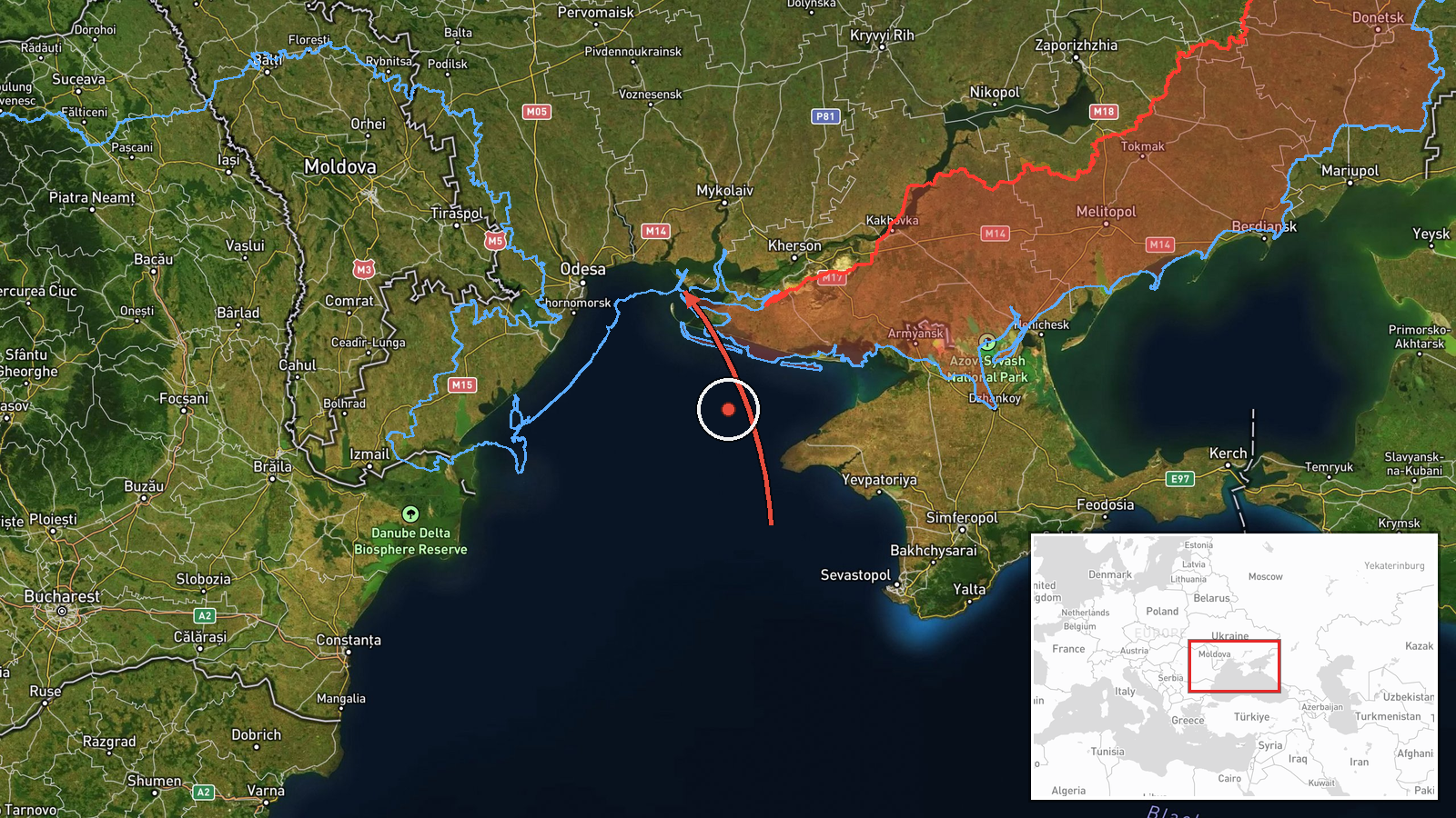
Ukrainian air monitoring, relayed through the Telegram channel @kpszsu, reported one Russian jet-powered Shahed-type drone, described as a Geran-3, heading toward Ochakiv in Mykolaiv Oblast from the Black Sea. The original Ukrainian-language post refers to a jet UAV approaching Ochakiv from the water area of the Black Sea, describing the approach corridor rather than any impact. The timestamp is 19 October 2026, 06:28 UTC. The report says nothing about damage, casualties, or interception, and the event is logged as a drone transit. Attribution to Russia follows the weapon designation used by the monitor and the established pattern of Shahed use in southern Ukraine.
Context and assessment
Ochakiv lies on the Black Sea coast near the mouth of the Dnipro-Buh estuary, a small port town whose position makes it a recurring point of approach for drones entering Mykolaiv Oblast from the sea. The related events show a sustained sequence over roughly thirty hours. On 18 October a single Shahed-type drone was logged coming from the Black Sea toward southern Odesa Oblast. On 19 October, monitoring recorded a drone heading toward northern Mykolaiv Oblast at 03:00 UTC, another toward southern Mykolaiv Oblast at 03:07 UTC, and a drone passing north of Buialyk at 05:25 UTC. The Ochakiv report fits this corridor: single or small groups of jet-powered drones tracking from the sea through the southern coastal districts. The repeated use of the Geran-3 designation suggests a jet-powered variant being flown along coastal routes, which could be consistent with reconnaissance, saturation, or pressure on air defence and infrastructure, though the data alone cannot establish intent. Because each entry is a sighting rather than a confirmed impact, the sequence points to persistent probing of the region more than a known strike plan.
Sources and confidence
The report comes from a single Telegram channel, @kpszsu, which is the only listed source, so cross-confirmation is absent. The channel is tied to Ukrainian air monitoring, which gives it operational relevance, but a single relay carries no independent verification. The confidence score of 8.0 reflects a credible official-linked feed with a precise timestamp and a sequence consistent with related reports, offset by the lack of a second source. Confidence would rise with corroboration from regional military administration statements, radar-based tracking, or impact reports, and would fall if the trajectory were later revised or the designation disputed.
Location
The coordinates are at settlement precision for Ochakiv, Ukraine, with high location confidence, meaning the point marks the town rather than a specific facility. Ochakiv sits on the northwestern Black Sea coast in Mykolaiv Oblast, on low, flat steppe terrain with lagoons and estuary shoreline. Nearby features include the Dnipro-Buh estuary and the adjacent Black Sea coastline, which shape the approach corridor drones take from the sea.
Related events nearby
- Ukrainian air monitoring: 1 Russian jet-powered Shahed (Geran-3) drone from Black Sea toward southern Mykolaiv2026-10-19 06:53 UTC · Drone Transit · southern Mykolaiv Oblast, Ukraine
- Ukrainian air monitoring: 2+ Russian jet-powered Shahed (Geran-3) drones heading toward southern Mykolaiv Obla2026-10-19 03:07 UTC · Drone Transit · southern Mykolaiv Oblast, Ukraine
- Ukrainian air monitoring: 1 Russian jet-powered Shahed (Geran-3) drone passing north of Buialyk, heading north2026-10-19 05:25 UTC · Drone Transit · north of Buialyk, Ukraine
- Ukrainian air monitoring: 1 Russian jet-powered Shahed (Geran-3) drone heading toward northern Mykolaiv Oblast2026-10-19 03:00 UTC · Drone Transit · northern Mykolaiv Oblast, Ukraine
▶ View this event on the live map

Intel Mapper aggregates open-source reports from monitored Telegram and X channels, geolocates them, cross-checks duplicates across sources and assigns a confidence score. Entries are updated as new confirmations arrive. Read how we verify events.