Ukrainian monitoring reports one jet-powered Geran-3 drone transiting Khmelnytskyi Oblast
What happened
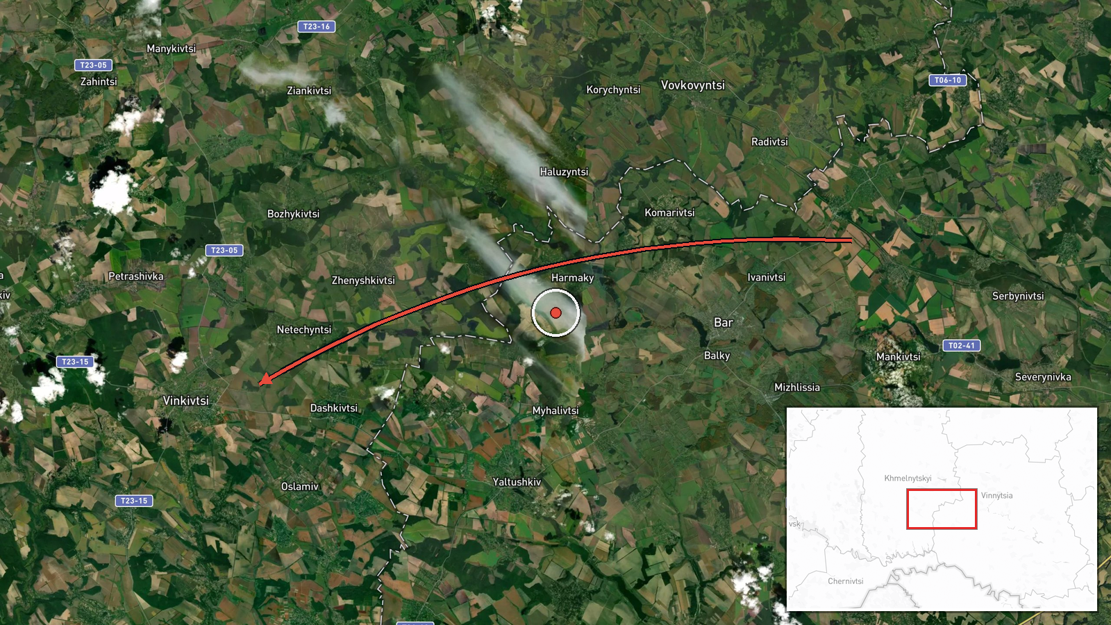
Ukrainian air monitoring on Telegram (@kpszsu) reported at 14:25 UTC on 19 October 2026 a single Russian jet-powered Shahed, designated Geran-3, flying from Vinnytsia Oblast on a course toward Khmelnytskyi Oblast. The Ukrainian-language post, which uses the phrase 'reactive UAV,' names the settlement of Vinkivtsi as the reported direction. It describes a transit, not a strike, and reports no damage, casualties, or final position. Attribution to Russia and the drone type rest on the channel's wording.
Context and assessment
Khmelnytskyi Oblast lies in western Ukraine, north of Vinnytsia, and hosts logistics and military-related sites that have been targets in earlier phases of the war. Vinkivtsi sits near the Vinnytsia border, so the track falls within a corridor that long-range drones have used when routing toward western and central Ukraine. The related events show a sustained pattern on the same day. At 05:17 UTC a Geran-3 was reported passing Voronovytsya toward Zhmerynka, a rail junction in Vinnytsia Oblast. At 07:57 UTC two or more jet-powered drones were reported moving from Vinnytsia toward Khmelnytskyi Oblast, and on the previous evening a Banderol mini cruise missile was reported heading toward the same oblast. Repeated Khmelnytskyi-directed reports between 14:01 and 14:25 suggest a continuing axis rather than a single stray drone. Operationally, this may indicate successive waves routed through central Ukraine toward the western oblasts, with transit reporting used to track flight paths. These readings remain provisional, since the data does not show target selection or intent.
Sources and confidence
Only one channel, Telegram @kpszsu, carries this report. The record lists a single source and no independent cross-confirmation from another outlet, an official Air Force statement, or a wire service at the time of logging. The confidence score of 8.0 reflects a specialized air-monitoring channel with consistent recent reporting, offset by the single-source status and the absence of corroborating track data. Confidence would rise with confirmation from a second monitoring source, official Air Force updates, or radar-based track reporting, and would fall if the channel corrected the track or if later reports placed the drone elsewhere.
Location
The coordinates correspond to Vinkivtsi, a village in Khmelnytskyi Oblast, tagged at settlement precision with high location confidence. The point is a named settlement reference from the original post rather than a measured drone position, so the actual flight path may have differed. The village lies in the rolling agricultural terrain of Podillia in western Ukraine, close to the Vinnytsia border. Khmelnytskyi city, the oblast capital, lies to the northwest.
Related events nearby
- Ukrainian air monitoring: 1 Russian jet-powered Shahed (Geran-3) drone heading toward Khmelnytskyi.2026-10-19 14:01 UTC · Drone Transit · Khmelnytskyi, Ukraine
- Ukrainian air monitoring: 1 Russian jet-powered Shahed (Geran-3) drone over Khmelnytskyi.2026-10-19 14:01 UTC · Drone Transit · Khmelnytskyi, Ukraine
- Ukrainian air monitoring: 2+ Russian jet-powered Shahed (Geran-3) drones from Vinnytsia Oblast toward Khmelnyt2026-10-19 07:57 UTC · Drone Transit · Khmelnytskyi Oblast, Ukraine
- Ukrainian air monitoring: 1 Russian Banderol mini cruise missile heading toward Khmelnytskyi Oblast.2026-10-18 19:33 UTC · Cruise Missile · Khmelnytskyi Oblast, Ukraine
- Ukrainian air monitoring: 1 Russian jet-powered Shahed (Geran-3) drone passing Voronovytsya, heading toward Zh2026-10-19 05:17 UTC · Drone Transit · Zhmerynka, Ukraine
▶ View this event on the live map

Intel Mapper aggregates open-source reports from monitored Telegram and X channels, geolocates them, cross-checks duplicates across sources and assigns a confidence score. Entries are updated as new confirmations arrive. Read how we verify events.