Single Geran-3 jet drone reported moving from northern Chernihiv into northern Kyiv Oblast
What happened
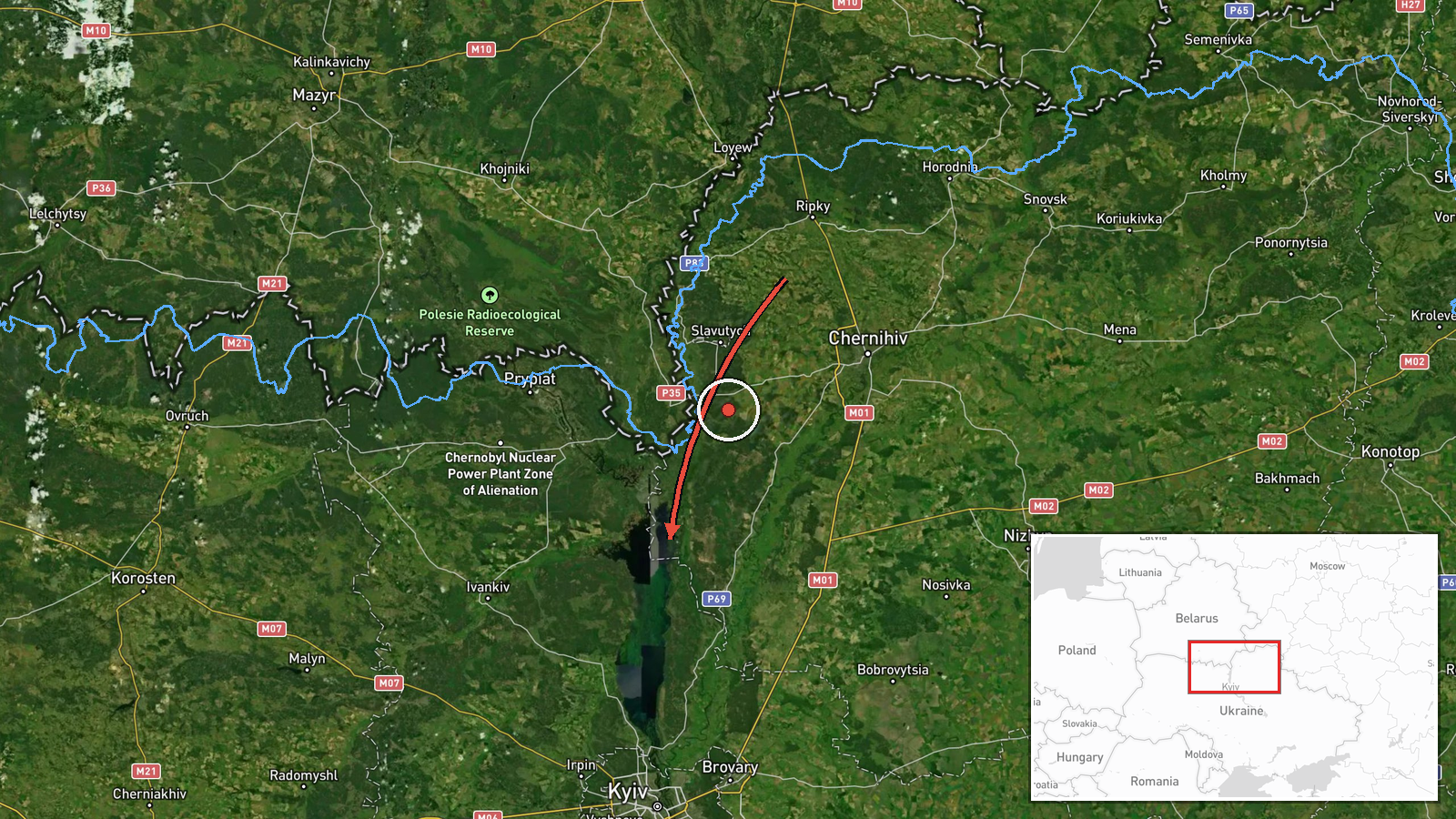
Ukrainian air monitoring reported via the Telegram channel @kpszsu that one Russian jet-powered Shahed, designated Geran-3, was moving from northern Chernihiv Oblast toward northern Kyiv Oblast. The post was timed 16:02 UTC on 19 October 2026. The original Ukrainian-language message uses the term jet UAV (реактивний БпЛА) and an arrow to show direction, running from the north of Chernihivshchyna to the north of the Kyiv region. The message does not report impact, damage, casualties, or interception, and it does not name a specific settlement. Because this is a transit notice rather than a strike report, its outcome cannot be established from this source alone. The event is recorded as a single-channel report.
Context and assessment
Northern Kyiv Oblast and the adjacent Chernihiv border zone have seen repeated air activity on this date, which makes this report part of a sustained pattern rather than an isolated sighting. Earlier on 19 October, monitoring reported two or more Geran-3 drones passing northern Kyiv Oblast heading southwest, and a single drone passing the same area heading west. A separate Geran-3 report placed a drone moving from Chernihiv Oblast toward the Kyiv Reservoir at 14:02. Cruise missiles were also logged near Kozelets at 03:43 and near Vyshhorod the previous evening, with a Banderol mini cruise missile passing the Kyiv Reservoir. Taken together, the sequence suggests repeated approach routes from the north and northwest toward the capital area. Operationally, such frequent transit notices may indicate probing or route testing, decoy or saturation tactics, or simply the movement of drones through corridors that air defense units then track. The data cannot show which of these applies, and the drones' final targets are not stated.
Sources and confidence
The report comes from one Telegram channel, @kpszsu, which Ukrainian air monitoring messages are commonly posted through. No independent outlet, second channel, or official statement has been matched to this specific drone in the available data. The confidence score of 8.0 reflects a credible official-style source with a clear, time-stamped message, but it is held below the top range because there is no cross-confirmation and the report is a transit notice without outcome details. Confidence would rise with corroboration from a second monitoring channel, regional military administration statements, or radar-based tracking references. It would fall if the track were later revised, corrected, or matched to a different drone or a false alarm.
Location
The coordinates (50.995, 30.520) are a regional-level approximation for northern Kyiv Oblast, not a named settlement or facility, and the location confidence is recorded as low for that reason. The actual track passed through a broad area rather than a single point. The surrounding terrain is largely flat Polissia lowland, crossed by river valleys including the Dnipro and Desna systems, with forest and wetland cover in parts of the north. The Kyiv Reservoir lies to the south of the coordinates and is one of the landmarks referenced in related reports.
Related events nearby
- Ukrainian air monitoring: 2+ Russian jet-powered Shahed (Geran-3) drones passing northern Kyiv Oblast, heading2026-10-19 05:21 UTC · Drone Transit · northern Kyiv Oblast, Ukraine
- Ukrainian air monitoring: 1 Russian jet-powered Shahed (Geran-3) drone passing northern Kyiv Oblast, heading w2026-10-19 02:45 UTC · Drone Transit · northern Kyiv Oblast, Ukraine
- Ukrainian air monitoring: 1 Russian jet-powered Shahed (Geran-3) drone from Chernihiv Oblast toward Kyiv Reser2026-10-19 14:02 UTC · Drone Transit · Kyiv Reservoir, Ukraine
- Ukrainian air monitoring: 1 Russian cruise missile heading toward Kozelets.2026-10-19 03:43 UTC · Cruise Missile · Kozelets, Ukraine
- Ukrainian air monitoring: 1 Russian Banderol mini cruise missile passing Kyiv Reservoir, heading toward Vyshho2026-10-18 19:41 UTC · Cruise Missile · Vyshhorod, Ukraine
▶ View this event on the live map

Intel Mapper aggregates open-source reports from monitored Telegram and X channels, geolocates them, cross-checks duplicates across sources and assigns a confidence score. Entries are updated as new confirmations arrive. Read how we verify events.