Ukrainian air monitoring reports one jet-powered Shahed drone moving from Odesa Oblast into Kirovohrad Oblast
What happened
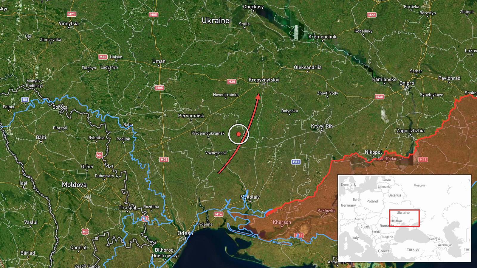
A Telegram post from the channel @kpszsu, which carries Ukrainian air monitoring updates, reported one Russian jet-powered Shahed drone, described as a Geran-3, passing near Savran in Odesa Oblast and moving on toward Kirovohrad Oblast. The post was logged at 01:08 UTC on 20 October 2026. The original Ukrainian wording describes a 'jet-powered UAV' flying past Savran and continuing into Kirovohrad region, with an arrow indicating direction of travel. The post does not describe any impact, casualties, or damage, and it names no intended target or precise point of detection. The event is classed as a drone transit rather than a strike.
Context and assessment
The report fits a pattern of repeated Geran-3 tracks across Kirovohrad Oblast in the preceding day. Between 03:19 and 07:11 UTC on 19 October, monitoring posts placed jet-powered Shahed drones near Kropyvnytskyi, toward Adzhamka, over central Kirovohrad Oblast heading northwest, and in a group of two or more heading west. A further track passed Kropyvnytskyi district heading west at 00:53 UTC on 20 October. Kropyvnytskyi is the oblast's administrative centre and a significant rail and industrial hub, so repeated sightings there are notable for monitoring purposes. The jet-powered variant is generally faster than the piston-engined Shahed type, which shortens the warning window for populated areas. Taken together, the reports suggest drones using a corridor through central Ukraine on multiple occasions. Transit reports alone do not show where these aircraft were headed, and they may be en route to western targets, used as decoys, or simply diverted. Transit tracking mainly indicates monitoring and air defence coverage rather than confirmed damage.
Sources and confidence
The event rests on a single Telegram channel, @kpszsu, with no independent outlet or second monitoring source cited in the data. The confidence score of 8.0 reflects a clear, specific, geolocated-to-region report from an established monitoring channel, but it is tempered by the lack of cross-confirmation and the fact that transit posts are brief and hard to verify after the fact. Confidence would rise with corroboration from Ukraine's Air Force statements, regional military administration posts, or other monitoring accounts naming the same track and timing. It would fall if later updates revised the drone's route, type, or count, or if the report proved to be a duplicate of an earlier track.
Location
The point coordinates are approximate and reflect a region-level placement at the centroid of Kirovohrad Oblast, not a settlement or facility, so the precise location of the track within the oblast is unknown. Savran, the place named in the original post, lies in northern Odesa Oblast near the border with Kirovohrad Oblast, which explains the direction of travel. Kirovohrad Oblast is a largely agricultural region in central Ukraine, crossed by the Inhul and other river valleys, with Kropyvnytskyi as its main city.
Related events nearby
- Ukrainian air monitoring: 2+ Russian jet-powered Shahed (Geran-3) drones passing Kirovohrad Oblast, heading we2026-10-19 07:11 UTC · Drone Transit · Kirovohrad Oblast, Ukraine
- Ukrainian air monitoring: one Russian jet-powered Shahed (Geran-3) drone tracked approaching Kropyvnytskyi fro2026-10-19 03:21 UTC · Drone Transit · Kropyvnytskyi, Kirovohrad Oblast, Ukraine
- Ukrainian air monitoring: 1 Russian jet-powered Shahed (Geran-3) drone passing Kropyvnytskyi district, heading2026-10-20 00:53 UTC · Drone Transit · Kropyvnytskyi district, Ukraine
- Ukrainian air monitoring: jet-powered Shahed (Geran-3) drones tracked over central Kirovohrad Oblast, heading 2026-10-19 04:43 UTC · Drone Transit · Central Kirovohrad Oblast, Ukraine
- Ukrainian air monitoring: 1 Russian jet-powered Shahed (Geran-3) drone passing Kropyvnytskyi, heading toward A2026-10-19 03:19 UTC · Drone Transit · Adzhamka, Ukraine
▶ View this event on the live map

Intel Mapper aggregates open-source reports from monitored Telegram and X channels, geolocates them, cross-checks duplicates across sources and assigns a confidence score. Entries are updated as new confirmations arrive. Read how we verify events.