Single jet-powered Shahed (Geran-3) drone reported heading toward Irpin, Kyiv Oblast, on 20 October
What happened
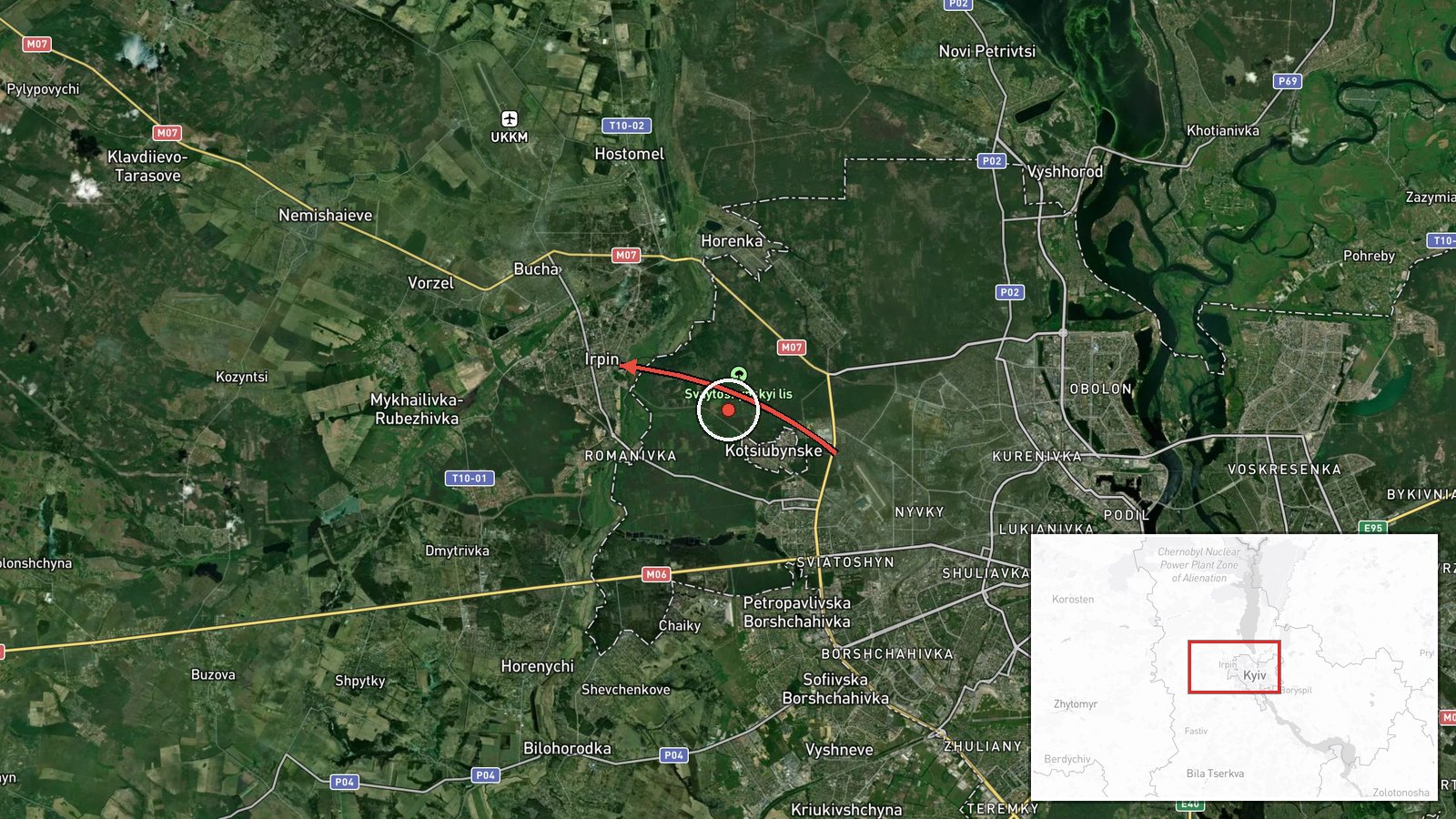
On 20 October 2026, at about 11:14 UTC, Ukraine's air monitoring channel on Telegram (@kpszsu) reported a single Russian jet-powered Shahed, designated Geran-3, moving in the Kyiv Oblast on a course toward Irpin. The original post, written in Ukrainian, describes it as a jet-type unmanned aerial vehicle (БпЛА) heading for Irpin, and the English summary is a translation of that wording. The report notes only the drone's type, its direction, and the settlement it was tracking toward. It does not describe any impact, damage, casualties, or interception. The alert is one of several Shahed transit warnings issued across Kyiv and its surroundings that morning.
Context and assessment
Irpin is a satellite city northwest of Kyiv, closely linked to the capital by road, rail and the Irpin River valley, and it was heavily fought over during the 2022 advance on Kyiv. Its position on the approach corridor makes it a plausible waypoint for drones routed toward the capital. The related events from the same morning show a sequence of Geran-3 transit alerts moving through Vorzel, Horenychi, Akademmistechko, Shuliavka and Borshchahivka, all placed in or around Kyiv. This pattern suggests a single or small group of drones tracked along a consistent north-western approach rather than a set of separate strikes. Operationally, a cluster of transit warnings of this kind is most often read as aerial monitoring of inbound flight paths, and may reflect either a probing route or a drone heading for a defined target farther along the track. The data alone cannot establish which, and the alerts do not confirm the intended destination.
Sources and confidence
The event rests on one Telegram channel, @kpszsu, which is the official air monitoring account associated with the Ukrainian Air Force. No second outlet in the dataset independently reports this specific Irpin track. The related Shahed alerts that morning come from the same kind of monitoring feed, which supports consistency but does not verify this particular track. The confidence score of 8.0 reflects a credible official source with a high-precision location, offset by single-source status and the lack of later confirmation. Confidence would rise with corroboration from independent monitoring, local authority statements, or flight-path reconstruction. It would fall if the track were revised or if later reporting showed a different destination.
Location
The location is recorded at settlement level for Irpin, Ukraine, at approximately 50.522 N, 30.240 E, which is the town centre rather than a specific facility. The alert gives the settlement as the reference point, so the coordinates represent the named town and not a surveyed site. Irpin lies in the Kyiv Oblast just outside the city's northwestern boundary, on relatively flat terrain near the Irpin River and the Kyiv reservoir area. Residential districts, rail lines and the Kyiv ring road corridor are the main features in the surrounding landscape.
Related events nearby
- Ukrainian air monitoring: 1 Russian jet-powered Shahed (Geran-3) drone heading toward Vorzel.2026-10-20 09:52 UTC · Drone Transit · Vorzel, Ukraine
- Ukrainian air monitoring: 1 Russian jet-powered Shahed (Geran-3) drone heading toward Akademmistechko, Kyiv.2026-10-20 10:20 UTC · Drone Transit · Akademmistechko, Kyiv, Ukraine
- Ukrainian air monitoring: 1 Russian jet-powered Shahed (Geran-3) drone heading toward Horenychi.2026-10-20 10:22 UTC · Drone Transit · Horenychi, Ukraine
- Ukrainian air monitoring: 1 Russian jet-powered Shahed (Geran-3) drone heading toward Borshchahivka, Kyiv.2026-10-20 11:04 UTC · Drone Transit · Borshchahivka, Kyiv, Ukraine
- Ukrainian air monitoring: 1 Russian jet-powered Shahed (Geran-3) drone heading toward Shuliavka, Kyiv.2026-10-20 10:20 UTC · Drone Transit · Shuliavka, Kyiv, Ukraine
▶ View this event on the live map

Intel Mapper aggregates open-source reports from monitored Telegram and X channels, geolocates them, cross-checks duplicates across sources and assigns a confidence score. Entries are updated as new confirmations arrive. Read how we verify events.