Single jet-powered Shahed-type drone reported moving from Odesa toward Vinnytsia Oblast
What happened
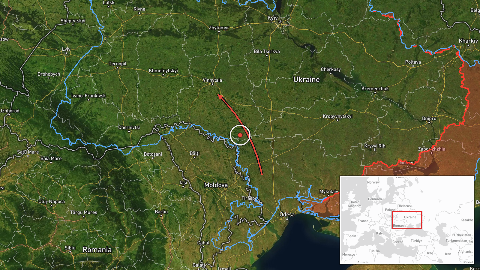
Ukrainian air monitoring reported at about 02:45 UTC on 21 October 2026 that one Russian jet-powered Shahed, designated Geran-3, was moving from Odesa Oblast toward Vinnytsia Oblast in west-central Ukraine. The alert was posted on Telegram by the channel @kpszsu, and its original Ukrainian wording describes a jet-type UAV flying from the Odesa region to the Vinnytsia region. The report names no impact, damage, or casualties and does not state a final track or landing point. It is one entry in a series of drone-transit notices covering the same corridor over the previous day. The source describes a transit rather than a strike, so this page records movement, not confirmed harm.
Context and assessment
Vinnytsia Oblast lies in the Podillia region of west-central Ukraine, and drones moving from the Black Sea coast toward western and central regions have repeatedly crossed it. Its significance for transit reporting is largely geographic: it sits between the Odesa coast and deeper territory to the west and north, so drones routed through it are often tracked by air monitoring before they leave Ukrainian airspace or reach a target. The related events show a dense pattern on 20 October 2026, with five drone-transit notices logged between 05:49 and 12:15 UTC. Morning reports describe groups of two or more drones crossing the oblast or moving from Odesa, while later reports describe single drones passing Podilsk district and Tyvriv and heading toward Vinnytsia. The sustained sequence suggests repeated waves or individual aircraft over a single day, though the data do not show whether specific sites were aimed at. Operationally, a lone jet-powered drone entering the oblast at night may be a trailing element of a larger launch, a decoy, or a route check, and reporting alone cannot separate these explanations. The pattern is most useful as an indicator of where air defence and monitoring are being stretched, not as evidence of a particular target.
Sources and confidence
The event rests on one Telegram post from @kpszsu, a monitoring channel associated with Ukraine's Air Force, and no independent outlet, wire service, or second channel is listed as confirming it. The confidence score of 8.0 is relatively high for a single source because the channel is an official, routinely updated air-alert feed, and the wording matches the format of the related entries in the series. Confidence would rise with a second official channel, a regional military administration statement, or independent flight-tracking or radar corroboration. It would fall if later updates retract or revise the track, or if the drone is reclassified.
Location
The coordinates, 49.23 N and 28.47 E, closely match the city of Vinnytsia, the administrative centre of the oblast. The source names only Vinnytsia Oblast, so the location is recorded at region precision with low location confidence, and the marker should be read as an approximate centre of the oblast rather than a confirmed point of flight. Vinnytsia Oblast sits in west-central Ukraine within the historic Podillia region, drained largely by the Southern Bug river, and it neighbours Odesa Oblast to the south. The terrain is mostly rolling agricultural land.
Related events nearby
- Ukrainian air monitoring: 1 Russian jet-powered Shahed (Geran-3) drone passing Tyvriv, heading toward Vinnytsi2026-10-20 12:15 UTC · Drone Transit · Vinnytsia, Ukraine
- Ukrainian air monitoring: 2+ Russian jet-powered Shahed (Geran-3) drones from Odesa Oblast toward Vinnytsia Ob2026-10-20 08:13 UTC · Drone Transit · Vinnytsia Oblast, Ukraine
- Ukrainian air monitoring: 1 Russian jet-powered Shahed (Geran-3) drone passing Vinnytsia Oblast, heading west.2026-10-20 08:13 UTC · Drone Transit · Vinnytsia Oblast, Ukraine
- Ukrainian air monitoring: 1 Russian jet-powered Shahed (Geran-3) drone passing Podilsk district, heading towar2026-10-20 07:29 UTC · Drone Transit · Vinnytsia Oblast, Ukraine
- Ukrainian air monitoring: 2+ Russian jet-powered Shahed (Geran-3) drones passing Vinnytsia Oblast, heading wes2026-10-20 05:49 UTC · Drone Transit · Vinnytsia Oblast, Ukraine
▶ View this event on the live map

Intel Mapper aggregates open-source reports from monitored Telegram and X channels, geolocates them, cross-checks duplicates across sources and assigns a confidence score. Entries are updated as new confirmations arrive. Read how we verify events.