Ukrainian air monitoring reports jet-powered Shahed drone moving from Odesa Oblast toward Vinnytsia Oblast
What happened
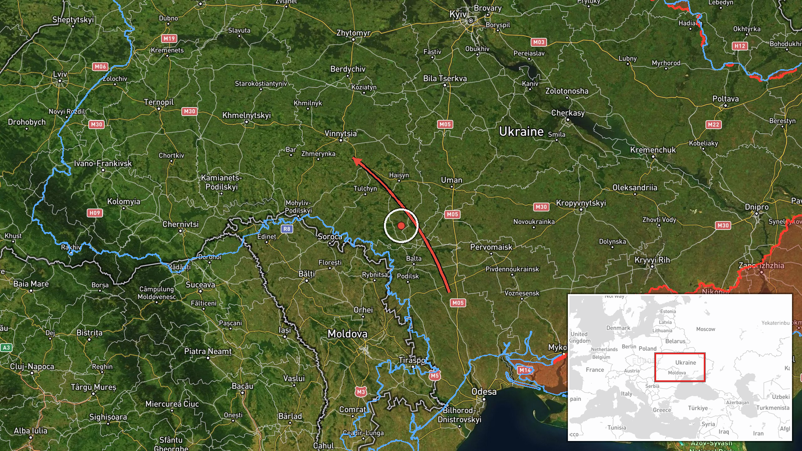
Ukraine's Air Force monitoring channel, reported on Telegram as @kpszsu, said at 09:29 UTC on 21 October 2026 that one jet-powered Shahed drone, identified in the post as a Geran-3, was moving from the north of Odesa Oblast toward Vinnytsia Oblast on a northwest course. The original Ukrainian wording describes a jet-type UAV crossing from the north of Odesa region into Vinnytsia region, which indicates a track across the region rather than a reported strike. The post describes no impact, damage, or casualties. The alert is one of several in a sequence logged over roughly 24 hours, beginning on 20 October and continuing into the morning of 21 October. Because the report comes from a single channel, the track is as stated by that source and has not been independently confirmed by other outlets in the dataset.
Context and assessment
Vinnytsia Oblast sits in west-central Ukraine, between the Odesa region to the south and the Kyiv and Zhytomyr regions to the north, and it hosts rail and road links that connect the south with the centre and west of the country. The related reports place the drone repeatedly over the same area. On 20 October, the air monitoring channel logged a Geran-3 passing Tyvriv and then heading toward Zhmerynka, a railway junction in the oblast, and later tracked it toward Vinnytsia. On 21 October, further posts described the drone departing Odesa Oblast toward Vinnytsia Oblast at 02:45, then again at 07:07 and 08:33, before the 09:29 alert. The repetition suggests a single airframe or a small number of drones being followed across successive segments rather than separate strikes. Operationally, sustained transits over central oblasts may indicate routing toward targets further west or north, a decoy or saturation pattern, or simply the tracking of drones that remain airborne for long periods. Jet-powered variants are generally reported as faster than piston-engined Geran-2 models, which can shorten warning times. None of this establishes a target, and the reports themselves do not state one.
Sources and confidence
All the information in this entry comes from one Telegram channel, the Ukrainian Air Force monitoring account (@kpszsu), which is an official-type source with a generally consistent record of track alerts. The confidence score of 8.0 reflects that institutional origin and the consistency of the surrounding sequence, but it is held below the top of the scale because the report is single-source, the location is region-level only, and no corroborating outlet or impact report appears in the dataset. The entry is not marked as corrected. Confidence would rise with confirmation from additional Ukrainian official statements, independent tracking data, or a second outlet reproducing the track. It would fall if the channel issued a correction, if later alerts contradicted the course or origin, or if the track could not be matched to the adjacent reports.
Location
The location is a region-level geocode. The coordinates, 49.23 north and 28.47 east, approximate the centre of Vinnytsia Oblast, and the location confidence is recorded as low, so the point marks no settlement, facility, or target. Vinnytsia Oblast is an agricultural region on the Southern Bug river, with the city of Vinnytsia as its administrative centre. Nearby named places in the related reports include Zhmerynka, a major railway junction, and Tyvriv, both within the oblast. The pin should be read as a general area of the track rather than an exact position.
Related events nearby
- Ukrainian air monitoring: 1 Russian jet-powered Shahed (Geran-3) drone heading toward Vinnytsia Oblast.2026-10-21 08:33 UTC · Drone Transit · Vinnytsia Oblast, Ukraine
- Ukrainian air monitoring: 1 Russian jet-powered Shahed (Geran-3) drone heading toward Vinnytsia Oblast.2026-10-21 07:07 UTC · Drone Transit · Vinnytsia Oblast, Ukraine
- Ukrainian air monitoring: 1 Russian jet-powered Shahed (Geran-3) drone from Odesa Oblast toward Vinnytsia Obla2026-10-21 02:45 UTC · Drone Transit · Vinnytsia Oblast, Ukraine
- Ukrainian air monitoring: 1 Russian jet-powered Shahed (Geran-3) drone passing Tyvriv, heading toward Vinnytsi2026-10-20 12:15 UTC · Drone Transit · Vinnytsia, Ukraine
- Ukrainian air monitoring: 1 Russian jet-powered Shahed (Geran-3) drone heading toward Zhmerynka.2026-10-20 13:41 UTC · Drone Transit · Zhmerynka, Ukraine
▶ View this event on the live map

Intel Mapper aggregates open-source reports from monitored Telegram and X channels, geolocates them, cross-checks duplicates across sources and assigns a confidence score. Entries are updated as new confirmations arrive. Read how we verify events.