Jet-powered Geran-3 drone reported moving from Rivne Oblast toward northern Khmelnytskyi Oblast
What happened
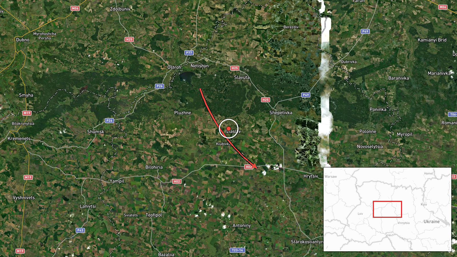
Ukrainian air monitoring reported one Russian jet-powered Shahed (Geran-3) drone traveling from Rivne Oblast toward northern Khmelnytskyi Oblast in western Ukraine on 21 October 2026, with a timestamp of 09:32 UTC. The report was posted on the Telegram channel @kpszsu, which carried the original message in Ukrainian describing a jet-type unmanned aerial vehicle moving from the Rivne region to the north of the Khmelnytskyi region. The message identifies the direction of travel but does not name a settlement, report impact, or state whether the drone was intercepted. The event is classified as a drone transit, meaning a track through Ukrainian airspace rather than a confirmed strike. No separate confirmation from another channel has been located.
Context and assessment
The track fits a sustained pattern of Shahed-type transits across western Ukraine over the preceding day. Related reports on 20 October placed single Geran-3 drones heading toward Liubar, Khmelnytskyi, and Shepetivka, with one entry noting a drone from Volyn Oblast on the same approach to Shepetivka. A further transit was logged toward eastern Rivne Oblast early on 21 October, roughly three hours before this report. Taken together, the sequence suggests a series of individual drones moving along a northwest to southeast corridor, a route often used to reach targets deeper in central and western Ukraine, including energy, rail, and logistics infrastructure. Because the drones are reported individually, the pattern more likely reflects a continuing stream of single-airframe launches than one coordinated salvo. The corridor also places western regional hubs within reach of drones launched from the north or east, which is why air monitoring is maintained across this belt. Operationally, multiple transits in a short window may be designed to stretch air defense coverage and early warning, although that interpretation cannot be confirmed from the reports alone.
Sources and confidence
The event rests on one channel, the Telegram account @kpszsu, which relays Ukrainian air monitoring messages and is generally regarded as an official-type source for aerial threat tracking. No second independent outlet has reproduced the report, so cross-confirmation is absent. The confidence score of 8.0 reflects a credible official-style origin and consistency with surrounding reports, but it is held below the top range because the message is a single, unverified tracking notice without an impact assessment or independent corroboration. Confidence would rise with confirmation from a second monitoring source, radar-based flight data, or a subsequent official statement on interception. It would fall if the track is later revised or shown to refer to a different airframe.
Location
The location is recorded at regional level, with coordinates near 49.97 north and 26.98 east, rather than at a named settlement, and the location confidence is rated low. The point was assigned because the report names only a broad direction within Khmelnytskyi Oblast. It lies in the northern part of the oblast, roughly 60 km north of the regional capital, Khmelnytskyi. The landscape is part of the Polissia lowlands, characterized by forest, wetlands, and river valleys, with sparse settlement density that can affect the ability to track low-flying drones.
Related events nearby
- Ukrainian air monitoring: 1 Russian jet-powered Shahed (Geran-3) drone heading toward Shepetivka; 1 Russian je2026-10-20 13:09 UTC · Drone Transit · Shepetivka, Ukraine
- Ukrainian air monitoring: 1 Russian jet-powered Shahed (Geran-3) drone heading toward Shepetivka.2026-10-20 12:51 UTC · Drone Transit · Shepetivka, Ukraine
- Ukrainian air monitoring: 1 Russian jet-powered Shahed (Geran-3) drone heading toward Liubar.2026-10-20 12:26 UTC · Drone Transit · Liubar, Ukraine
- Ukrainian air monitoring: 1 Russian jet-powered Shahed (Geran-3) drone heading toward Khmelnytskyi.2026-10-20 12:36 UTC · Drone Transit · Khmelnytskyi, Ukraine
- Ukrainian air monitoring: 1 Russian jet-powered Shahed (Geran-3) drone heading toward eastern Rivne Oblast.2026-10-21 06:14 UTC · Drone Transit · eastern Rivne Oblast, Ukraine
▶ View this event on the live map

Intel Mapper aggregates open-source reports from monitored Telegram and X channels, geolocates them, cross-checks duplicates across sources and assigns a confidence score. Entries are updated as new confirmations arrive. Read how we verify events.