Ukrainian Air Force reports 2+ jet-powered Shahed drones moving from Odesa toward Vinnytsia
What happened
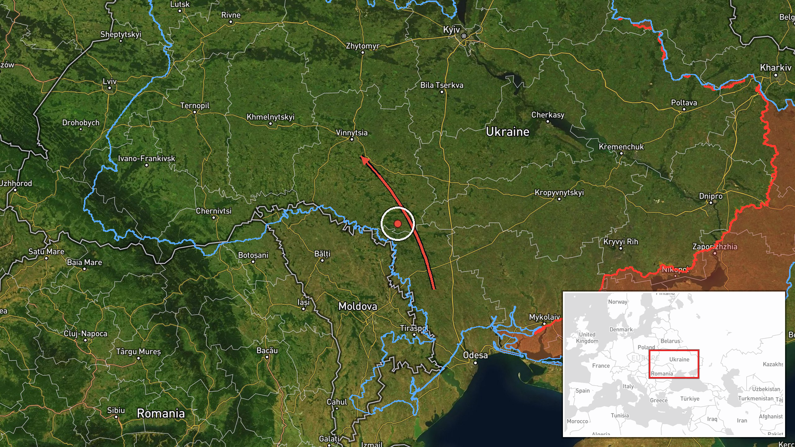
Ukraine's Air Force Telegram channel (@kpszsu) reported that at 11:42 UTC on 21 October 2026, at least two jet-powered Shahed (Geran-3) drones were moving from Odesa Oblast in southern Ukraine toward Vinnytsia Oblast in west-central Ukraine. The original post, written in Ukrainian, describes jet-type unmanned aerial vehicles on a course toward Vinnytsia. The report gives no impact location, damage, casualty information, or interception details. The wording describes a transit track rather than a confirmed strike, and the '2+' count suggests the number may have been updated as monitoring continued. The event is categorized as a drone transit, a label used for tracked flights within Ukrainian airspace before any strike is confirmed.
Context and assessment
This entry is the latest in a run of drone-transit reports for Vinnytsia Oblast on 20 and 21 October. Earlier posts logged a single Geran-3 passing Tyvriv on the evening of 20 October, then single drones from Odesa Oblast at 02:45 UTC, heading toward Vinnytsia at 07:07 and 08:33 UTC, and from northern Odesa Oblast at 09:29 UTC. The sequence shows the same southern-to-west corridor being used repeatedly, with the count rising from one to at least two by midday. Vinnytsia is a major regional city and transport hub, and the oblast hosts infrastructure of economic and military relevance, though the reports do not name a target. Operationally, repeated tracks along one axis may reflect routine transit of long-range drones bound for targets farther north or west, or a pattern of sustained probing of air defense coverage. Jet-powered variants fly faster than the older propeller-driven Shahed design, which shortens warning time for ground defenders and makes sustained tracking more demanding. Without an impact report or a named destination, the purpose of these flights cannot be determined from the available data.
Sources and confidence
The event rests on a single channel, the official Ukrainian Air Force Telegram account, which is generally the primary public source for air-threat warnings. The data shows no cross-confirmation from a second channel, regional military administration, or independent monitoring service, and no imagery is attached. The confidence score of 8.0 reflects the official origin of the post and its consistency with earlier same-day reports from the same channel, offset by the absence of corroboration and the single-source count. Confidence would rise with matching reports from independent trackers, regional authorities, or confirmed interception or impact statements. It would fall if the count or track were revised downward or if later official updates contradicted the initial warning. The record is not marked as corrected.
Location
The location is assigned at oblast level: Vinnytsia Oblast, with an approximate point at 49.23 N, 28.47 E. This is not a settlement or facility, and the location confidence is recorded as low. The oblast lies in west-central Ukraine and is largely agricultural with rolling terrain. The Southern Bug river runs through the region, and Vinnytsia city sits along it. Tyvriv, named in one related report, is also within the oblast area.
Related events nearby
- Ukrainian air monitoring: 1 Russian jet-powered Shahed (Geran-3) drone from northern Odesa Oblast toward Vinny2026-10-21 09:29 UTC · Drone Transit · Vinnytsia Oblast, Ukraine
- Ukrainian air monitoring: 1 Russian jet-powered Shahed (Geran-3) drone heading toward Vinnytsia Oblast.2026-10-21 08:33 UTC · Drone Transit · Vinnytsia Oblast, Ukraine
- Ukrainian air monitoring: 1 Russian jet-powered Shahed (Geran-3) drone heading toward Vinnytsia Oblast.2026-10-21 07:07 UTC · Drone Transit · Vinnytsia Oblast, Ukraine
- Ukrainian air monitoring: 1 Russian jet-powered Shahed (Geran-3) drone from Odesa Oblast toward Vinnytsia Obla2026-10-21 02:45 UTC · Drone Transit · Vinnytsia Oblast, Ukraine
- Ukrainian air monitoring: 1 Russian jet-powered Shahed (Geran-3) drone heading toward Zhmerynka.2026-10-20 13:41 UTC · Drone Transit · Zhmerynka, Ukraine
▶ View this event on the live map

Intel Mapper aggregates open-source reports from monitored Telegram and X channels, geolocates them, cross-checks duplicates across sources and assigns a confidence score. Entries are updated as new confirmations arrive. Read how we verify events.