Single jet-powered Shahed drone reported moving from Mykolaiv toward Kirovohrad Oblast on 21 October
What happened
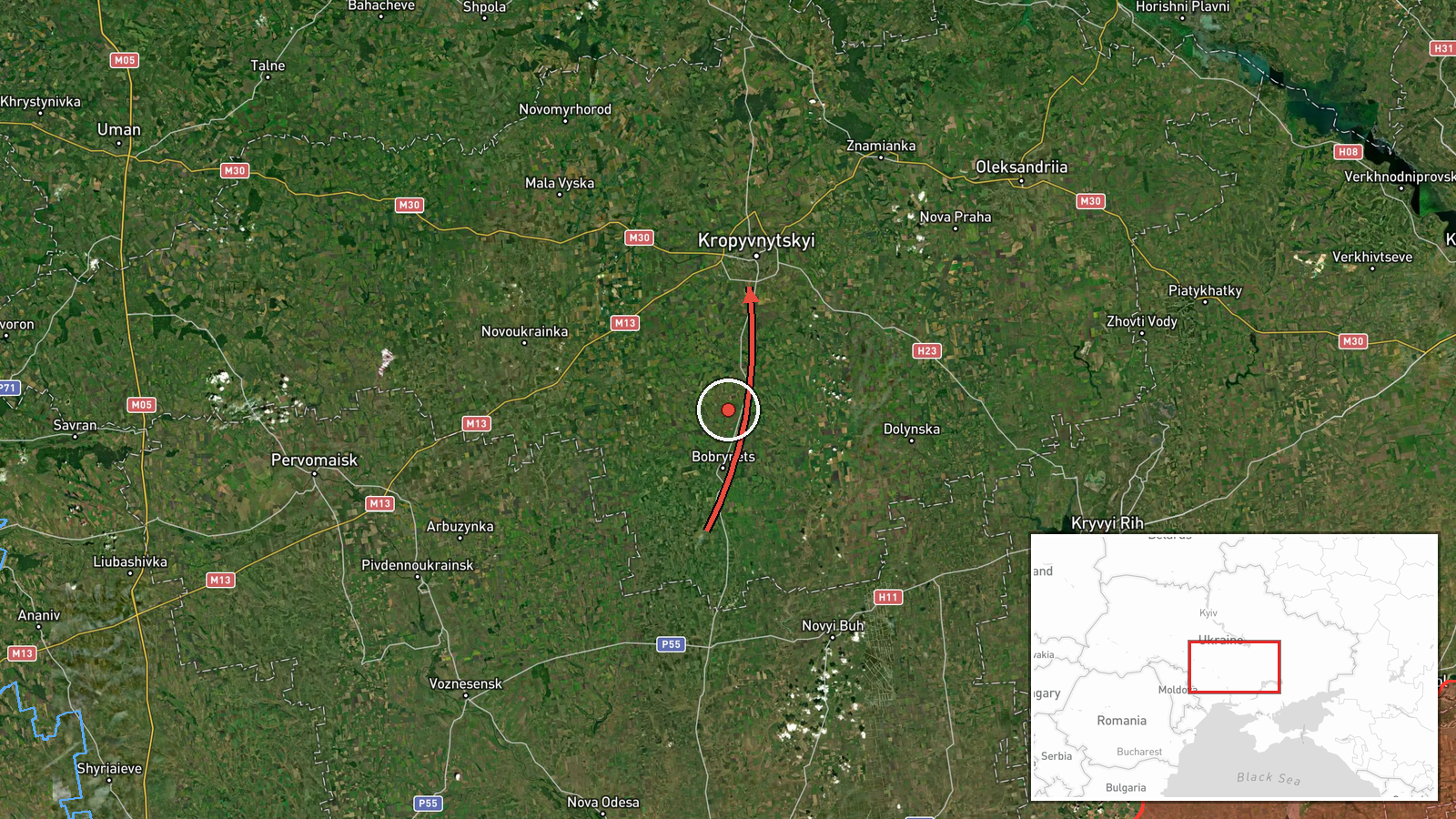
Ukrainian air monitoring reported through the Telegram channel @kpszsu that a single jet-powered drone was detected in northern Mykolaiv Oblast on a course toward Kirovohrad Oblast. The post was published at 13:06 UTC on 21 October 2026. Its original Ukrainian wording describes a jet-type UAV (реактивний БпЛА) and gives only the direction of travel. The English summary adds that the drone is a Russian Geran-3, a designation the original post does not state. The report names no impact point, no damage and no casualties. It is a transit notice that tracks a drone's movement through airspace rather than a confirmed strike.
Context and assessment
Kirovohrad Oblast sits on the main air corridor that Russian long-range drones have used to cross central Ukraine toward the west and north-west, so drones passing through it are a routine feature of the pattern. Earlier that morning, a mass overnight attack that included Iskander-K cruise missiles and 186 drones, among them jet Shaheds, was reported with 150 downed by Ukrainian air defense. Several other transit alerts the same day tracked jet drones from Poltava and Kirovohrad into neighbouring Cherkasy Oblast, and a separate alert at 12:08 UTC placed a jet drone heading toward Kropyvnytskyi, the oblast's administrative centre. Taken together, the sequence suggests a drone group moving in stages across successive oblasts rather than a single targeted approach. Operationally, a jet-powered airframe is faster than the older piston-engined Shahed, which reduces the warning window for air defense. The track does not, however, reveal the intended target, and transit notices of this kind are often followed by no reported impact at all.
Sources and confidence
The only channel reporting this event is the Telegram account @kpszsu, which relays Ukrainian air monitoring alerts. No independent outlet, wire service or official statement in the data corroborates it, so cross-confirmation is absent. The score of 8.0 reflects a credible official-style source with a specific, time-stamped report, offset by its single-channel basis and the fact that the post describes movement rather than an outcome. The score would rise if a second Ukrainian authority or a wire service confirmed the track, or if a later report named an impact point. It would fall if the track were revised, corrected or not matched by subsequent air-defense reporting.
Location
The event is tagged to Kirovohrad Oblast at region precision, and the post itself names no settlement, so the coordinates are an approximate regional point rather than a fixed site. The point lies close to Kropyvnytskyi, the oblast's administrative centre, which is where a related alert placed a drone the same day, but the location confidence is recorded as low. The oblast is largely flat steppe drained by rivers such as the Inhul, with a dense network of farmland and few natural barriers to low-flying drones.
Related events nearby
- Ukrainian air monitoring: 1 Russian jet-powered Shahed (Geran-3) drone from Mykolaiv Oblast toward Kirovohrad 2026-10-21 06:23 UTC · Drone Transit · Kirovohrad Oblast, Ukraine
- Ukrainian air monitoring: 1 Russian jet-powered Shahed (Geran-3) drone heading toward Kropyvnytskyi.2026-10-21 12:08 UTC · Drone Transit · Kropyvnytskyi, Ukraine
- Ukrainian Navy mobile fire group Sargan 3000 destroyed a Russian Shahed drone using the Sting interceptor dron2026-10-21 14:20 UTC · Air Defense · Ukraine (location not reported)
- Russia launched a mass overnight attack with Iskander-K cruise missiles and 186 drones, including jet Shaheds.2026-10-21 05:36 UTC · Cruise Missile · Ukraine (location not reported)
- Ukrainian air monitoring: 1 Russian jet-powered Shahed (Geran-3) drone from western Poltava Oblast toward Cher2026-10-21 14:08 UTC · Drone Transit · Cherkasy Oblast, Ukraine
▶ View this event on the live map

Intel Mapper aggregates open-source reports from monitored Telegram and X channels, geolocates them, cross-checks duplicates across sources and assigns a confidence score. Entries are updated as new confirmations arrive. Read how we verify events.