One jet-powered Geran-3 Shahed reported moving from Mykolaiv Oblast into Kirovohrad Oblast
What happened
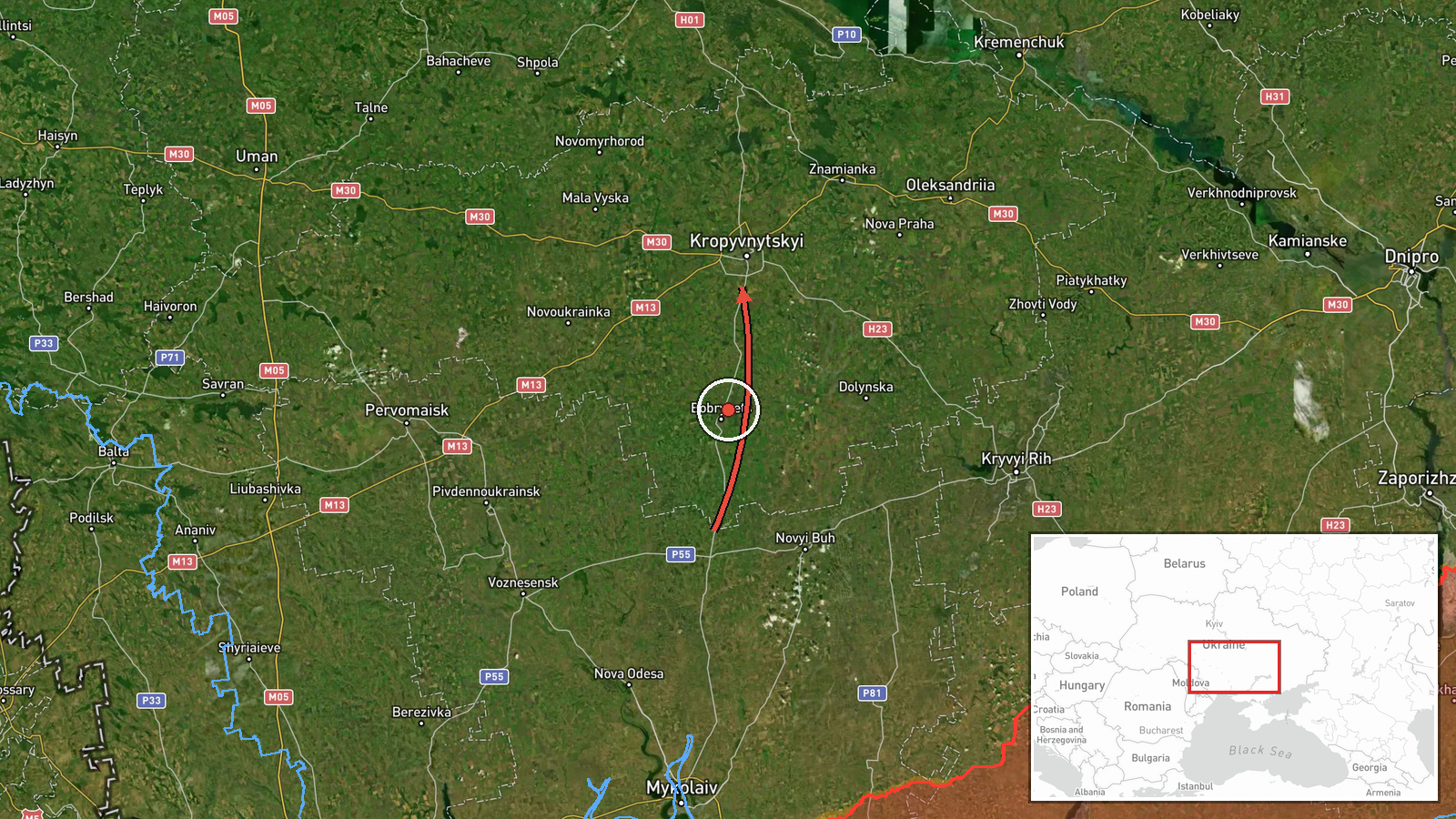
Ukrainian air monitoring, as relayed by the Telegram channel @kpszsu, reported a single Russian jet-powered Shahed, designated Geran-3, travelling from Mykolaiv Oblast into Kirovohrad Oblast on a north-western heading toward the Cherkasy direction. The report was posted on 21 October 2026 at 06:23 UTC. The original wording describes a 'jet-type UAV' moving along a north-western course, and it does not state an impact, a target, or whether the drone was intercepted. No casualties or damage are mentioned. The alert records a transit only, so the drone's final destination remains unknown.
Context and assessment
Kirovohrad Oblast sits in central Ukraine, on the route between the southern front regions and the central and western parts of the country, so drones heading north-west through it are a recurring feature of Russian long-range strike waves. The event fits a tight cluster of reports. On 20 October, a single Geran-3 was logged passing eastern Kirovohrad Oblast heading west, and a Geran-2 loitering munition was reported shot down that day. Early on 21 October, a mass overnight attack used Iskander-K cruise missiles and 186 drones, including jet Shaheds, and Ukrainian air defence reported 150 downed. Between 06:16 and 06:26 UTC, further groups of two or more Geran-3s were logged over Kremenchuk and moving from Poltava Oblast toward Cherkasy Oblast. Taken together, the pattern suggests that the lone drone was part of a wider overnight flight path across central Ukraine rather than an isolated launch. Operationally, such transits are usually read as route-tracking of the wave rather than evidence of a specific target in Kirovohrad Oblast.
Sources and confidence
The event rests on a single Telegram channel, @kpszsu, which posts Ukrainian air monitoring alerts. No independent outlet, official statement, or second channel was found to corroborate it in the data provided. The confidence score of 8.0 reflects a credible, time-stamped official-style alert with a clear heading, offset by the single-source status and the lack of follow-up confirmation. Confidence would rise with corroboration from a second monitoring channel, radar-based reporting, or a regional military administration statement. It would fall if later reporting showed the track had been misidentified or that the drone had been assigned to a different oblast.
Location
The location is recorded only at oblast level, Kirovohrad Oblast, Ukraine, and the coordinates are a generalised central point rather than a confirmed position, so the precision is set as region with low location confidence. The drone's exact track within the oblast is not given. Kirovohrad Oblast is largely flat to rolling steppe in central Ukraine, with agricultural land, the Ingul and other river valleys, and the Dnipro reservoir system to the east.
Related events nearby
- Footage shows a Ukrainian interceptor drone downing a Russian Geran-2 loitering munition; location not reporte2026-10-20 10:11 UTC · Drone Shootdown · Ukraine (location not reported)
- Ukrainian air monitoring: 1 Russian jet-powered Shahed (Geran-3) drone passing eastern Kirovohrad Oblast, head2026-10-20 08:13 UTC · Drone Transit · eastern Kirovohrad Oblast, Ukraine
- Russia launched a mass overnight attack with Iskander-K cruise missiles and 186 drones, including jet Shaheds.2026-10-21 05:36 UTC · Cruise Missile · Ukraine (location not reported)
- Ukrainian air monitoring: 2+ Russian jet-powered Shahed (Geran-3) drones from Poltava Oblast toward Cherkasy O2026-10-21 06:26 UTC · Drone Transit · Cherkasy Oblast, Ukraine
- Ukrainian air monitoring: 2+ Russian jet-powered Shahed (Geran-3) drones passing Kremenchuk, heading west.2026-10-21 06:16 UTC · Drone Transit · Kremenchuk, Ukraine
▶ View this event on the live map

Intel Mapper aggregates open-source reports from monitored Telegram and X channels, geolocates them, cross-checks duplicates across sources and assigns a confidence score. Entries are updated as new confirmations arrive. Read how we verify events.