Ukrainian monitors report one jet-powered Shahed drone heading toward Vinnytsia Oblast from Kirovohrad
What happened
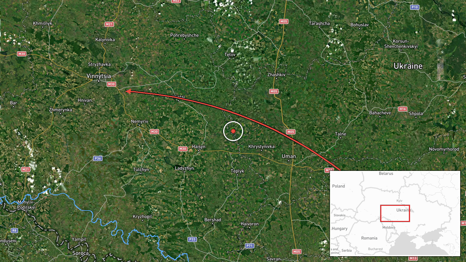
On 21 October 2026 at about 14:06 UTC, the Telegram channel @kpszsu, which is linked to Ukraine's air force monitoring reports, posted that a single Russian jet-powered Shahed (Geran-3) drone was operating in the western part of Kirovohrad Oblast and moving on a course toward Vinnytsia Oblast. The original post, written in Ukrainian, uses the phrase 'Реактивний БпЛА' (jet-powered UAV) and describes the track only as heading toward Vinnytsia, without reporting impact, damage, casualties or interception. The event is classed as a drone transit rather than a confirmed strike. The report is based on a single source, and the confidence score reflects that limitation.
Context and assessment
Vinnytsia Oblast, in central-west Ukraine, has become a recurring corridor for Shahed-type drones travelling from the south and west toward targets further north and east. It hosts regional infrastructure, rail and road junctions and energy assets, which makes it a plausible waypoint on routes aimed at more distant objectives. The related reports from the same day show a sustained pattern: at least five separate transit alerts between 02:45 and 11:42 UTC, several originating in Odesa Oblast and one in northern Odesa, all directed toward Vinnytsia. The repetition suggests a continuous flow of drones crossing the oblast rather than a single isolated launch. Operationally, the sequence may indicate that launch groups are being routed across central Ukraine, that some airframes are being tracked along long paths, or that the pattern is intended to stretch air defence and warning resources. Because the jet-powered Geran-3 variant is faster and harder to intercept than older piston-engine models, such alerts also carry a higher warning burden. None of these interpretations can be confirmed from a transit notice alone.
Sources and confidence
The event rests on one Telegram channel, @kpszsu, which carries official-style air monitoring alerts. No independent outlet or second channel in the dataset has confirmed this specific track, so cross-confirmation is absent. The confidence score of 8.0 is high relative to the single-source status, which likely reflects the channel's track record of routine transit reporting and the consistency of the same-day alerts. It would rise if a second Ukrainian authority, a wire agency or a regional administration confirmed the track or reported subsequent impact. It would fall if later updates contradicted the course, showed the drone leaving the area, or indicated the alert was superseded.
Location
The location is recorded at region level, Vinnytsia Oblast, with coordinates near 49.23 N, 28.47 E, which place the marker in the oblast's interior rather than at a specific settlement or facility. The geo precision is therefore regional and the location confidence is low, since the drone's exact position was not given. Vinnytsia Oblast lies in west-central Ukraine, largely on the Podolian Upland, with the Southern Bug river running through it and wooded and agricultural land across much of its territory. The oblast borders Kirovohrad and Odesa oblasts, which explains the reported approach path.
Related events nearby
- Ukrainian air monitoring: 2+ Russian jet-powered Shahed (Geran-3) drones heading toward Vinnytsia Oblast.2026-10-21 15:09 UTC · Drone Transit · Vinnytsia Oblast, Ukraine
- Ukrainian air monitoring: 2+ Russian jet-powered Shahed (Geran-3) drones from Odesa Oblast toward Vinnytsia Ob2026-10-21 11:42 UTC · Drone Transit · Vinnytsia Oblast, Ukraine
- Ukrainian air monitoring: 1 Russian jet-powered Shahed (Geran-3) drone from northern Odesa Oblast toward Vinny2026-10-21 09:29 UTC · Drone Transit · Vinnytsia Oblast, Ukraine
- Ukrainian air monitoring: 1 Russian jet-powered Shahed (Geran-3) drone heading toward Vinnytsia Oblast.2026-10-21 08:33 UTC · Drone Transit · Vinnytsia Oblast, Ukraine
- Ukrainian air monitoring: 1 Russian jet-powered Shahed (Geran-3) drone heading toward Vinnytsia Oblast.2026-10-21 07:07 UTC · Drone Transit · Vinnytsia Oblast, Ukraine
▶ View this event on the live map

Intel Mapper aggregates open-source reports from monitored Telegram and X channels, geolocates them, cross-checks duplicates across sources and assigns a confidence score. Entries are updated as new confirmations arrive. Read how we verify events.