Jet-powered Shahed-type drone tracked past Tetiiv toward Pohrebyshche, Vinnytsia Oblast
What happened
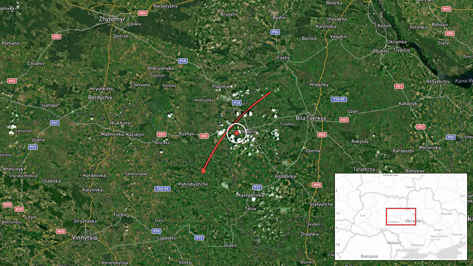
Ukraine's Air Force, through its official Telegram channel @kpszsu, reported a single jet-powered Shahed-type drone, designated Geran-3 in the wider reporting, moving past Tetiiv in Kyiv Oblast toward Vinnytsia Oblast, with Pohrebyshche named as the reference point. The report was logged on 22 October 2026 at 07:18 UTC. The original Ukrainian wording describes a reactive UAV (Реактивний БпЛА) in transit, a phrasing that indicates the drone was tracked in flight rather than reported as having struck anything. The post names no impact site, damage, casualties, or interception. The summary's phrase 'from Kyiv Oblast' is a paraphrase; the original places the drone past Tetiiv in Kyiv region and points it toward Vinnytsia region.
Context and assessment
Pohrebyshche is a small town in Vinnytsia Oblast, a region that has appeared repeatedly in Ukrainian air alerts over the past day. Five earlier drone-transit reports on 21 October, logged between 09:29 and 15:33 UTC, all placed Shahed-type drones on tracks toward Vinnytsia Oblast or Vinnytsia city, with some groups described as two or more aircraft. Those tracks originated in northern and southern Odesa Oblast and western Kirovohrad Oblast. The new report extends that pattern northward, with a drone crossing Kyiv region before entering Vinnytsia territory. Taken together, the sequence suggests a sustained stream of long-range drones routed across central Ukraine rather than a single isolated sortie. Such transit reports usually reflect air-defence tracking and do not themselves reveal the intended target. Possible readings include routing toward targets further west or north, saturation attempts, or decoy use, but the open reporting does not confirm any of these. The most useful next indicator would be a follow-up Air Force or regional report naming an impact location.
Sources and confidence
The event rests on a single Telegram post from @kpszsu, the official channel of the Ukrainian Air Force, which is generally a primary source for air-threat reporting. No independent outlet, regional administration, or second monitoring channel was found to corroborate the exact route or timing at the time of compilation. The confidence score of 8.0 reflects the authority of the originating channel and the specificity of the report, offset by the absence of cross-confirmation and the single-source basis. Confidence would rise if a second official channel, a regional military administration, or open-source flight-tracking analysts confirmed the track, and would fall if the Air Force later revised the route or reported that the drone had left the area.
Location
Location was assigned at settlement level: the post names Pohrebyshche as the reference point, and the coordinates correspond to that town rather than to any specific facility. The town lies in Vinnytsia Oblast in central-north Ukraine, near the boundary with Kyiv Oblast. The drone's reported track passes Tetiiv, a Kyiv Oblast town to the northwest, before reaching the Pohrebyshche area. The surrounding terrain is largely agricultural and open, with no notable fixed landmarks identified in the source.
Related events nearby
- Ukrainian air monitoring: 1 Russian jet-powered Shahed (Geran-3) drone heading toward Vinnytsia.2026-10-21 15:33 UTC · Drone Transit · Vinnytsia, Ukraine
- Ukrainian air monitoring: 2+ Russian jet-powered Shahed (Geran-3) drones heading toward Vinnytsia Oblast.2026-10-21 15:09 UTC · Drone Transit · Vinnytsia Oblast, Ukraine
- Ukrainian air monitoring: 1 Russian jet-powered Shahed (Geran-3) drone from western Kirovohrad Oblast toward V2026-10-21 14:06 UTC · Drone Transit · Vinnytsia Oblast, Ukraine
- Ukrainian air monitoring: 2+ Russian jet-powered Shahed (Geran-3) drones from Odesa Oblast toward Vinnytsia Ob2026-10-21 11:42 UTC · Drone Transit · Vinnytsia Oblast, Ukraine
- Ukrainian air monitoring: 1 Russian jet-powered Shahed (Geran-3) drone from northern Odesa Oblast toward Vinny2026-10-21 09:29 UTC · Drone Transit · Vinnytsia Oblast, Ukraine
▶ View this event on the live map

Intel Mapper aggregates open-source reports from monitored Telegram and X channels, geolocates them, cross-checks duplicates across sources and assigns a confidence score. Entries are updated as new confirmations arrive. Read how we verify events.