Single jet-powered Shahed (Geran-3) drone reported passing Ananyiv toward Vinnytsia Oblast
What happened
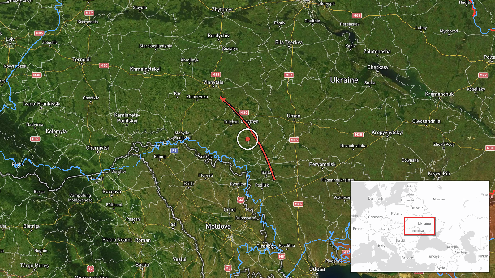
Ukrainian air monitoring posted on the Telegram channel @kpszsu, which is generally associated with Ukraine's Air Force, at 09:09 UTC on 22 October 2026. The post reported one jet-powered Russian Shahed-type drone, described as a Geran-3, passing Ananyiv on a course toward Vinnytsia Oblast. The original Ukrainian wording refers to a jet-powered UAV passing Ananyiv on a course toward the Vinnytsia region, under a heading naming Odesa Oblast. The report describes a transit only. It does not mention impacts, casualties, damage or interception. The alert came from a single channel and has not been repeated by other sources in the available data.
Context and assessment
Vinnytsia Oblast lies in central Ukraine, well north of the southern front and far from the immediate combat zone, which is why drones passing through it attract attention. The region hosts rail, energy and logistics infrastructure that is generally considered significant for Ukraine's national networks. The related events show a clear pattern. On 21 October 2026, Ukrainian monitoring posted at least five separate transit alerts between 09:29 and 15:33 UTC. Each one described Geran-3 drones moving toward Vinnytsia Oblast, with counts ranging from one to two or more. The routes began in northern and general Odesa Oblast and in western Kirovohrad Oblast, which suggests a sustained flow of drones moving north through the south and centre of the country. Operationally, a series of transits like this may indicate attempts to saturate or probe air defences, test routes, or draw interceptors. A transit alert on its own does not reveal the intended target, and it may also reflect routine tracking rather than a planned strike on the region.
Sources and confidence
All of the material rests on one Telegram channel, so cross-confirmation is currently absent. The confidence score of 8.0 reflects the routine, specific and internally consistent nature of the alert, which fits a series of similar posts from the same day. It is not a score for the outcome of the flight. Confidence would rise with corroboration from other Ukrainian air force or regional military administration posts, radar-based track reporting, or later reports of wreckage or impacts. It would fall if later official updates contradict the drone type, the route or the timing, or if the channel retracts or amends the post.
Location
The location is recorded at region level only, with a low confidence rating. The coordinates 49.23 N and 28.47 E approximate a point in Vinnytsia Oblast and do not match the reported observation at Ananyiv, which is a settlement in southwestern Odesa Oblast. The event is therefore best read as a route segment between Odesa Oblast and Vinnytsia Oblast, not a fixed site. The surrounding terrain is largely flat agricultural steppe with river valleys, which offers little natural cover for low-flying drones and tends to favour radar tracking.
Related events nearby
- Ukrainian air monitoring: 1 Russian jet-powered Shahed (Geran-3) drone heading toward Vinnytsia.2026-10-21 15:33 UTC · Drone Transit · Vinnytsia, Ukraine
- Ukrainian air monitoring: 2+ Russian jet-powered Shahed (Geran-3) drones heading toward Vinnytsia Oblast.2026-10-21 15:09 UTC · Drone Transit · Vinnytsia Oblast, Ukraine
- Ukrainian air monitoring: 1 Russian jet-powered Shahed (Geran-3) drone from western Kirovohrad Oblast toward V2026-10-21 14:06 UTC · Drone Transit · Vinnytsia Oblast, Ukraine
- Ukrainian air monitoring: 2+ Russian jet-powered Shahed (Geran-3) drones from Odesa Oblast toward Vinnytsia Ob2026-10-21 11:42 UTC · Drone Transit · Vinnytsia Oblast, Ukraine
- Ukrainian air monitoring: 2+ Russian jet-powered Shahed (Geran-3) drones passing southern Vinnytsia Oblast, he2026-10-21 18:54 UTC · Drone Transit · southern Vinnytsia Oblast, Ukraine
▶ View this event on the live map

Intel Mapper aggregates open-source reports from monitored Telegram and X channels, geolocates them, cross-checks duplicates across sources and assigns a confidence score. Entries are updated as new confirmations arrive. Read how we verify events.