One Shahed-type drone reported heading north from Black Sea across Odesa-Mykolaiv border
What happened
Ukrainian air monitoring reported on 23 October 2026 at 02:17 UTC that one Russian Shahed-type drone was passing over the Black Sea and heading north along the boundary of Odesa and Mykolaiv regions. The Ukrainian-language original, posted by the Telegram channel @kpszsu, describes the objects as strike UAVs on a northern course along the regional border, while the English summary refers to a single drone in transit. The report does not state whether the drone entered Ukrainian land territory, whether it was tracked to a specific target, or whether any impact or damage occurred. No casualties or losses are recorded for this entry, and it is classed as a drone transit rather than a confirmed strike.
Context and assessment
Russia has conducted a long-running campaign of Shahed-type long-range drone attacks against Ukraine since 2022, and the coastal Odesa and Mykolaiv regions have repeatedly been on the routes these drones take from the south and southwest. The related events on 22 October 2026 show a dense sequence of five single-drone transit reports between 07:15 and 17:01 UTC, concentrated around Ochakiv, Berezanka, Mykolaiv and the Mykolaiv district. Two entries for Ochakiv carry near-identical wording and times 08:35 and 09:35, which may reflect repeated tracking of the same object rather than separate drones. The related reports describe a jet-powered Geran-3 variant, although this entry names only a Shahed-type drone. Taken together, the pattern points to repeated single drones moving from sea toward coastal settlements over roughly a day. Operationally, this may suggest routing over water to approach the coast with less warning, or the use of maritime launch points, though the data does not establish either. It may also indicate that air defense units are tracking drones already in flight rather than observing new launches. The sequence is best read as a tempo indicator rather than evidence of a specific intended target.
Sources and confidence
The event rests on a single Telegram channel, @kpszsu, which is widely associated with Ukrainian military air monitoring. No independent wire service, official second channel or open-source imagery corroborates the transit in the data provided. The confidence score of 8.0 reflects a credible official-origin channel, a precise timestamp and consistency with the surrounding reports, but it is held below the top range because the post is unconfirmed by any second source and the report lacks track data. Confidence would rise with corroboration from a second Ukrainian authority, an independent tracking service, or a reported impact or interception. It would fall if later updates reclassified the object, withdrew the warning, or showed the track was a duplicate of an earlier report.
Location
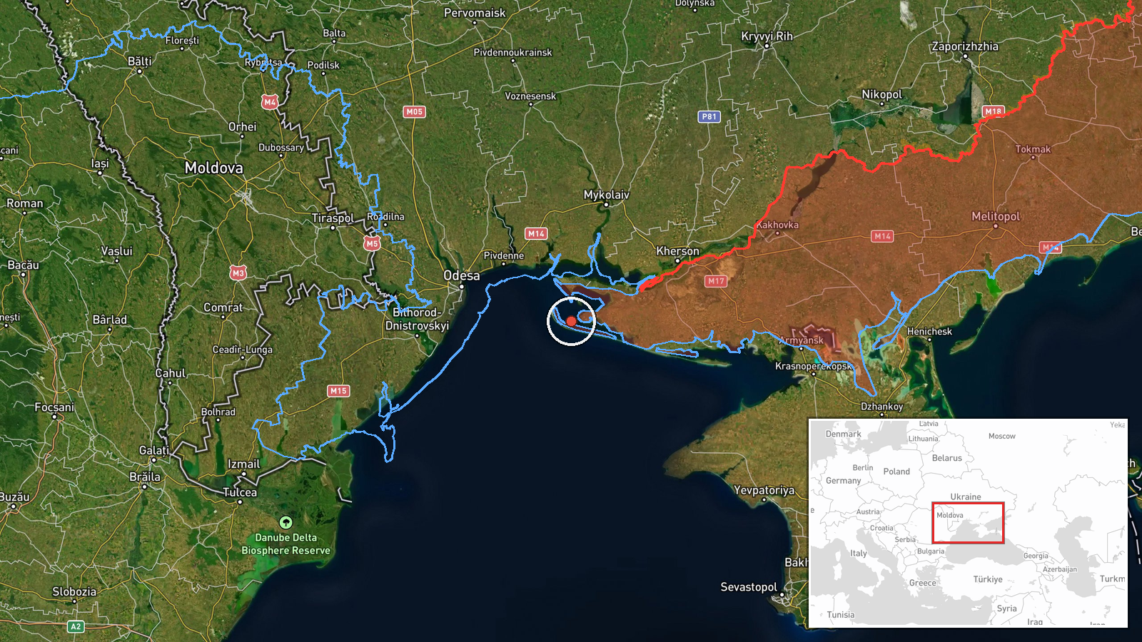
The coordinates 46.2785 N, 31.6855 E are marked at region-level precision rather than at a settlement, so the pin shows an approximate area and not an exact position. The point lies over Black Sea waters off the Ukrainian coast, in the maritime approach between the Odesa and Mykolaiv regions. Nearby landmarks include the Kinburn Spit and the Dnipro-Bug estuary, while Ochakiv and the Mykolaiv area lie to the west and north. Because the entry concerns a drone in transit over water, the location describes a route segment rather than a point of impact.
Related events nearby
- Ukrainian air monitoring: 1 Russian jet-powered Shahed (Geran-3) drone from Black Sea toward Ochakiv.2026-10-22 09:35 UTC · Drone Transit · Ochakiv, Ukraine
- Ukrainian air monitoring: 1 Russian jet-powered Shahed (Geran-3) drone from Black Sea toward Ochakiv.2026-10-22 08:35 UTC · Drone Transit · Ochakiv, Ukraine
- Ukrainian air monitoring: 1 Russian jet-powered Shahed (Geran-3) drone passing Berezanka, heading northwest.2026-10-22 16:58 UTC · Drone Transit · Berezanka, Ukraine
- Ukrainian air monitoring: 1 Russian jet-powered Shahed (Geran-3) drone heading toward Mykolaiv.2026-10-22 17:01 UTC · Drone Transit · Mykolaiv, Ukraine
- Ukrainian air monitoring: 1 Russian jet-powered Shahed (Geran-3) drone passing Mykolaiv district, heading nort2026-10-22 07:15 UTC · Drone Transit · Mykolaiv district, Ukraine
▶ View this event on the live map

Intel Mapper aggregates open-source reports from monitored Telegram and X channels, geolocates them, cross-checks duplicates across sources and assigns a confidence score. Entries are updated as new confirmations arrive. Read how we verify events.