Russian Geran-3 jet drone reported passing Smotrych toward Ternopil Oblast
What happened
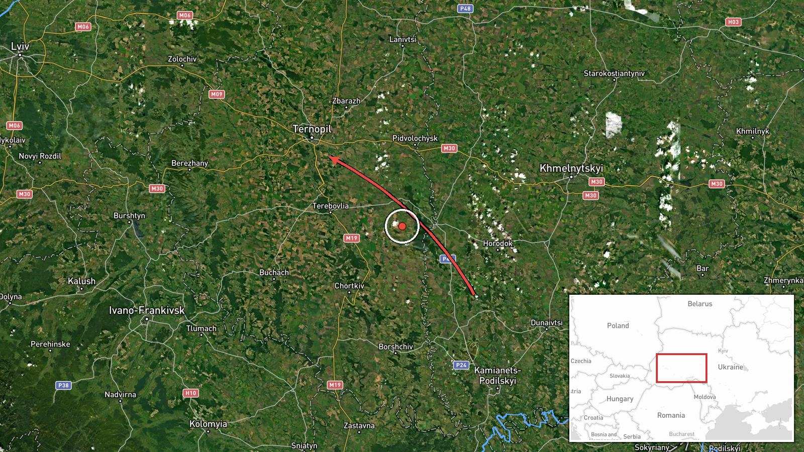
Ukrainian air monitoring reported on Telegram that one Russian jet-powered Shahed-type drone, identified in the post as a Geran-3, was passing near Smotrych and heading toward Ternopil Oblast. The post was published on 23 October 2026 at 08:47 UTC. The event is recorded as a drone transit rather than a strike, and the feed reports no impact, casualties or damage. The original Ukrainian wording uses a jet-drone icon and an arrow to indicate direction of travel, describing the drone as moving past Smotrych onward into the Ternopil region. The attribution to Russia and the Geran-3 designation both come from this single monitoring message rather than from independent confirmation.
Context and assessment
Western Ukraine has repeatedly served as a transit corridor for Russian long-range drones, which are often launched from the east and cross the country toward targets far from the front. Related records show a cluster of monitoring reports from the same morning. Between 03:11 and 08:58 UTC, alerts placed drones near Kopychyntsi and Khodoriv heading west, passing through Ternopil Oblast heading northwest at 06:40, moving toward Burshtyn in Ivano-Frankivsk Oblast at 06:53, and passing Kozova heading northwest. The pattern suggests either several drones or repeated sightings of one or more aircraft tracking across the region over several hours, although the records do not establish whether these are distinct aircraft. Ternopil and neighbouring oblasts contain energy, rail and logistics assets, so such tracks may prompt defensive and warning measures across a wide area. Mixed headings, including both westward and northwestward movement, may indicate routing toward western targets, dispersal, or changes of course in response to air defence; the data cannot distinguish these. Jet-powered variants are faster than older piston-engine Shaheds, which can shorten warning times for local authorities. The Kozova entry is timestamped 08:58, after this event's 08:47 time, so the feed is not strictly chronological.
Sources and confidence
The only channel in this record is the Telegram channel listed as @kpszsu, which posts Ukrainian air monitoring alerts. The source count is one, and no outlet in the provided data independently reports this transit. The confidence score of 8.0 reflects a channel that posts consistent, specific transit alerts, offset by single-source status and the absence of any impact or interception report. Confidence would rise if Ukrainian air force or regional military administration statements matched the track, or if other outlets reported the same drone. It would fall if the channel corrected or withdrew the alert, or if the related transit posts turned out to describe the same drone with inaccurate positions.
Location
The location is recorded at region level for Ternopil Oblast with low location confidence, so the coordinates are an approximate regional point rather than a fixed position on Smotrych. The post names Smotrych, a settlement the data does not place precisely, so the marker should be read as a general area within the oblast. Ternopil Oblast is largely rolling farmland in western Ukraine, with river valleys and the Podillia uplands in the region. The exact position of the drone along the track is not known from this record.
Related events nearby
- Ukrainian air monitoring: 1 Russian jet-powered Shahed (Geran-3) drone passing Ternopil Oblast, heading northw2026-10-23 06:40 UTC · Drone Transit · Ternopil Oblast, Ukraine
- Ukrainian air monitoring: 1 Russian jet-powered Shahed (Geran-3) drone passing Kozova, heading northwest.2026-10-23 08:58 UTC · Drone Transit · Kozova, Ukraine
- Ukrainian air monitoring: one Russian jet-powered Shahed (Geran-3) drone tracked near Kopychyntsi, Ternopil Ob2026-10-23 03:11 UTC · Drone Transit · Kopychyntsi, Ternopil Oblast, Ukraine
- Ukrainian air monitoring reports a Russian Shahed-type drone heading toward Burshtyn, Ivano-Frankivsk Oblast.2026-10-23 06:53 UTC · Drone Transit · Burshtyn, Ivano-Frankivsk Oblast, Ukraine
- Ukrainian air monitoring: 1 Russian jet-powered Shahed (Geran-3) drone passing Khodoriv, heading west.2026-10-23 03:30 UTC · Drone Transit · Khodoriv, Ukraine
▶ View this event on the live map

Intel Mapper aggregates open-source reports from monitored Telegram and X channels, geolocates them, cross-checks duplicates across sources and assigns a confidence score. Entries are updated as new confirmations arrive. Read how we verify events.