Jet-powered Shahed-type drone reported heading toward Khmilnyk, Vinnytsia Oblast
What happened
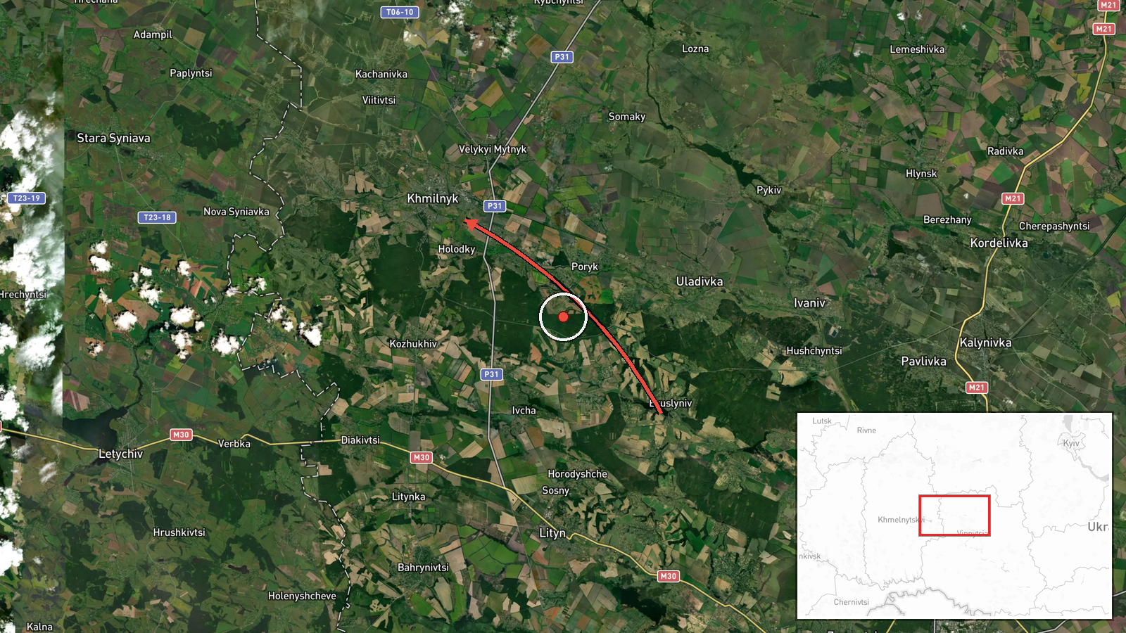
Ukraine's Air Force monitoring channel on Telegram (@kpszsu) reported at 11:43 UTC on 23 October 2026 a single jet-powered unmanned aerial vehicle moving toward Khmilnyk in Vinnytsia Oblast from the northeast. The original post is a short Ukrainian-language alert describing a jet-type UAV in the direction of Khmilnyk from the northeast. The event summary attributes the object to Russia and identifies it as a Shahed-series drone, specifically the Geran-3 variant, a jet-powered design. The report does not say whether the drone struck anything, reached a specific target, or was intercepted, and it gives no information on damage or casualties. The entry is classed as a drone transit, meaning it records movement through airspace rather than a confirmed strike. The type identification rests on the channel's description and the desk's classification.
Context and assessment
Khmilnyk is a town in west-central Ukraine, well behind the front line, and the report sits within a dense run of similar alerts across Vinnytsia Oblast on the same day. Related entries show a single Geran-3 drone from Odesa Oblast heading toward Vinnytsia at 08:13 UTC, another passing Podilsk district toward the oblast at 09:15, and a group of at least two passing the oblast heading northwest at 11:49. Earlier, at 07:23 and on the evening of 22 October, further single drones were reported crossing the oblast or heading toward Vinnytsia city. This pattern suggests that drones are being tracked entering from the south and southeast and moving across the oblast over several hours, with several separate tracks rather than one sustained attack. Operationally, transit alerts of this kind often mean the drones are being followed along routes toward targets further north, west or northwest, and a settlement name may indicate the drone's position relative to a town rather than an aim point. Vinnytsia Oblast hosts rail, road and industrial infrastructure, but the data does not link this track to any particular facility, so such a reading remains uncertain.
Sources and confidence
The entry rests on one channel, Telegram @kpszsu, and the dataset records no independent cross-confirmation from another monitoring source, regional administration, or media outlet. The confidence score of 8.0 reflects a channel tied to official air monitoring that issues frequent alerts, combined with the specificity of the direction and time. It is held below the maximum because the report is single-source, relies on a brief alert with no imagery, and carries no impact details. Confidence would rise with corroboration from regional military administration statements, other monitoring channels or wire services, or physical evidence such as wreckage. It would fall if later reporting contradicted the track, reassigned the drone type, or if the channel issued a correction. The entry is currently not marked as corrected.
Location
The coordinates are set at settlement level for Khmilnyk, and the location confidence is recorded as high because the alert names the town directly. The point marks the town rather than any facility, as no specific site is named. Khmilnyk lies in Vinnytsia Oblast in west-central Ukraine, in the Podillia region, an area of rolling upland and river valleys. Its surroundings include agricultural land and a rail connection typical of the region, and the wider oblast is a transit corridor for drones moving west and northwest from the southern and southeastern front areas.
Related events nearby
- Ukrainian air monitoring: 2+ Russian jet-powered Shahed (Geran-3) drones passing Vinnytsia Oblast, heading nor2026-10-23 12:02 UTC · Drone Transit · Vinnytsia Oblast, Ukraine
- Ukrainian air monitoring: 2+ Russian jet-powered Shahed (Geran-3) drones passing Vinnytsia Oblast, heading nor2026-10-23 11:49 UTC · Drone Transit · Vinnytsia Oblast, Ukraine
- Ukrainian air monitoring: 1 Russian jet-powered Shahed (Geran-3) drone passing Podilsk district, heading towar2026-10-23 09:15 UTC · Drone Transit · Vinnytsia Oblast, Ukraine
- Ukrainian air monitoring: 1 Russian jet-powered Shahed (Geran-3) drone from Odesa Oblast toward Vinnytsia Obla2026-10-23 08:13 UTC · Drone Transit · Vinnytsia Oblast, Ukraine
- Ukrainian air monitoring: 1 Russian jet-powered Shahed (Geran-3) drone passing Vinnytsia Oblast, heading north2026-10-23 07:23 UTC · Drone Transit · Vinnytsia Oblast, Ukraine
▶ View this event on the live map

Intel Mapper aggregates open-source reports from monitored Telegram and X channels, geolocates them, cross-checks duplicates across sources and assigns a confidence score. Entries are updated as new confirmations arrive. Read how we verify events.