Jet-powered Shahed drone reported moving from Odesa Oblast toward Vinnytsia Oblast
What happened
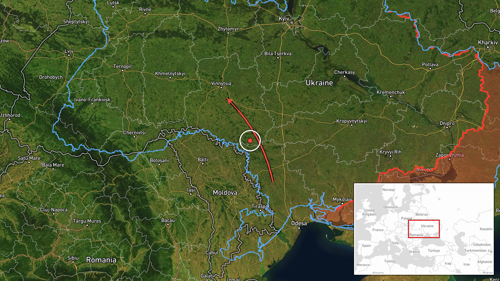
Ukraine's Air Force monitoring channel on Telegram reported at 08:13 UTC on 23 October 2026 that one Russian jet-powered Shahed-type drone, identified in the report as a Geran-3, was passing Podilsk in Odesa Oblast and moving in the direction of Vinnytsia Oblast. The original Ukrainian wording describes a jet-powered UAV ("Реактивний БпЛА") flying past Podilsk toward the Vinnytsia region. The report gives no altitude, exact track position, intended target, or impact. It is recorded as a drone transit rather than a strike, and the attribution to Russia follows the channel's description of the aircraft as a Russian Shahed-series drone.
Context and assessment
Vinnytsia Oblast sits in west-central Ukraine, north of Odesa Oblast, and the city of Vinnytsia is a regional administrative center with transport links and industry, which helps explain why air monitoring tracks drones crossing it. The same corridor appears repeatedly in related reports. A Geran-3 was reported passing Ananyiv toward Vinnytsia Oblast on 22 October at 09:09 UTC, followed by several reports over or toward Vinnytsia city between 17:28 and 17:41 UTC, and another at 07:23 UTC on 23 October describing a drone passing the oblast and heading northwest. Together these suggest either one airframe or several drones moving through the oblast over more than a day, though the reports do not confirm they are the same aircraft. Operationally, repeated transits through one region may indicate routing around air defenses in neighboring areas, reconnaissance of routes, loitering, or an effort to stretch warning and interception resources. Jet-powered variants are generally faster than the piston-engine Shahed design, which can shorten warning times. None of the reports describe impacts, so this sequence is best read as monitoring data rather than evidence of an attack on a specific target.
Sources and confidence
Only one channel reported this transit: the Telegram account @kpszsu, which relays Ukrainian Air Force air-situation updates. The related events come from the same kind of monitoring feed, so they add context but not independent confirmation of this specific report. The confidence score of 8.0 reflects an official, time-stamped source, offset by single-sourcing and a general description with no independent radar data, imagery, or video. Confidence would rise with a second air-monitoring or regional military administration report naming the same drone, or with a more precise track. It would fall if a correction changed the direction, aircraft type, or timing.
Location
The location is recorded at region level as Vinnytsia Oblast, with coordinates 49.23, 28.47 approximating the oblast's center rather than any settlement or facility, so location confidence is low. The report itself names Podilsk in Odesa Oblast as a point the drone passed, while Vinnytsia is only the stated direction. The oblast is largely agricultural, with gentle plains and river valleys, and the Southern Bug River runs through parts of the region.
Related events nearby
- Ukrainian air monitoring: 1 Russian jet-powered Shahed (Geran-3) drone passing Podilsk district, heading towar2026-10-23 09:15 UTC · Drone Transit · Vinnytsia Oblast, Ukraine
- Ukrainian air monitoring: 1 Russian jet-powered Shahed (Geran-3) drone passing Vinnytsia Oblast, heading north2026-10-23 07:23 UTC · Drone Transit · Vinnytsia Oblast, Ukraine
- Ukrainian air monitoring: 1 Russian jet-powered Shahed (Geran-3) drone heading toward Vinnytsia.2026-10-22 17:41 UTC · Drone Transit · Vinnytsia, Ukraine
- Ukrainian air monitoring: 1 Russian jet-powered Shahed (Geran-3) drone over Vinnytsia.2026-10-22 17:32 UTC · Drone Transit · Vinnytsia, Ukraine
- Ukrainian air monitoring: 1 Russian jet-powered Shahed (Geran-3) drone heading toward Vinnytsia.2026-10-22 17:28 UTC · Drone Transit · Vinnytsia, Ukraine
▶ View this event on the live map

Intel Mapper aggregates open-source reports from monitored Telegram and X channels, geolocates them, cross-checks duplicates across sources and assigns a confidence score. Entries are updated as new confirmations arrive. Read how we verify events.