Ukraine reports jet-powered drone group moving from Chernihiv border toward Kyiv Oblast
What happened
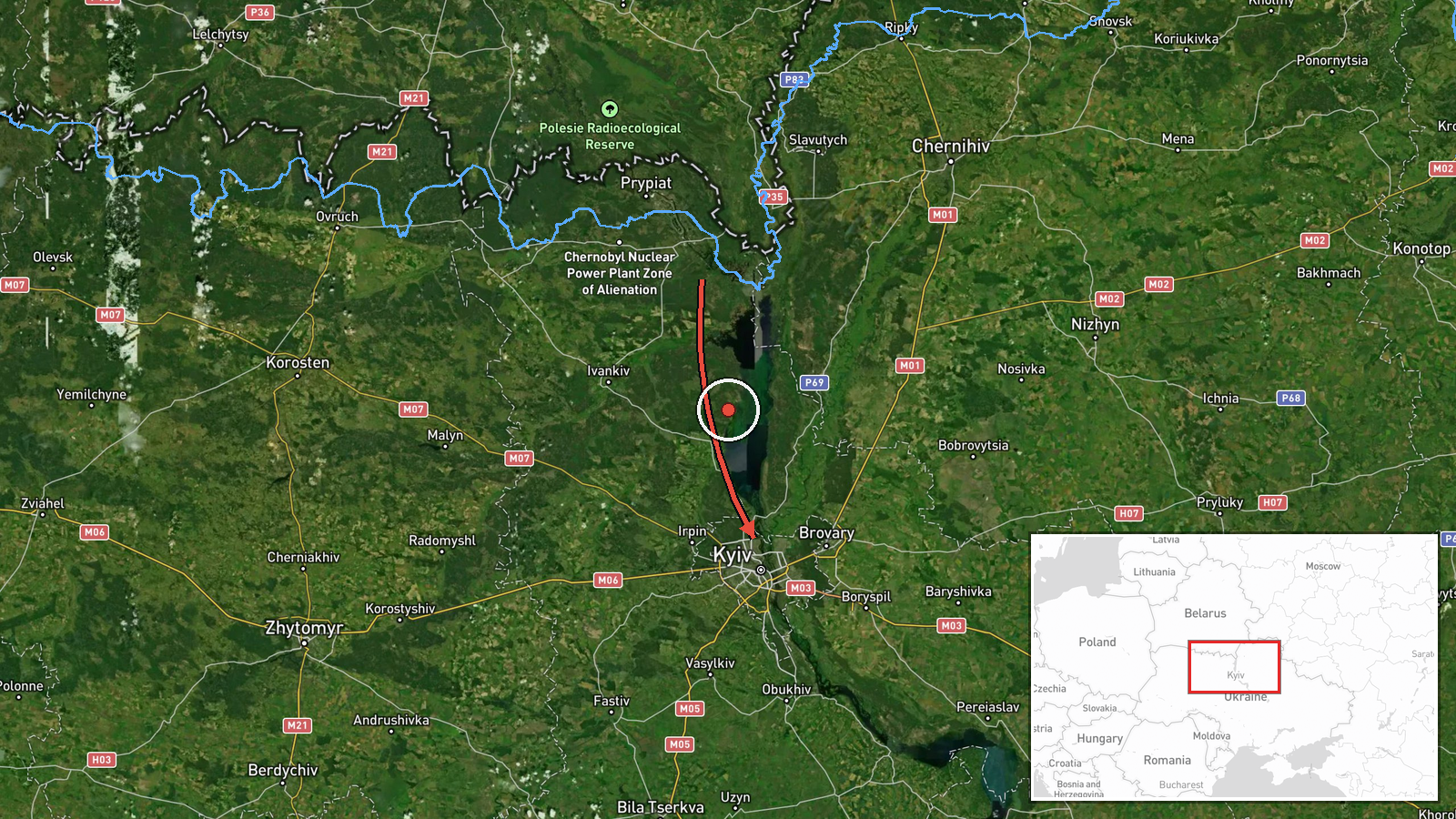
A Telegram channel associated with Ukraine's Air Force, @kpszsu, reported on 23 October 2026 at 11:52 UTC a group of jet-powered unmanned aerial vehicles moving through northern Chernihiv Oblast along the border with Belarus, heading toward Kyiv Oblast. The original Ukrainian wording describes a group of jet-type UAVs in the north of Chernihiv region, while the English summary identifies them as Russian Shahed (Geran-3) type drones and says they came from Belarus. The post gives no count beyond the summary's '2+' figure and does not describe impacts, casualties or interceptions. The report sits within a run of similar alerts that morning, several of which tracked drones over Kyiv city and past Slavutych between 01:00 and 11:12 UTC. Attribution to Russia reflects the channel's framing and standard Ukrainian reporting on Shahed-type systems rather than independent confirmation.
Context and assessment
Kyiv and its surrounding oblast are a persistent target of long-range drone attacks, and the capital's government, political and energy infrastructure make it a recurring focus for air defence. The related events show a sustained pattern on the same date: repeated reports of two or more Geran-3 drones over Kyiv at 01:04 and 03:14 UTC, one drone heading toward the city at 08:28, and a drone group passing Slavutych at 03:00 on the approach from the north. The 11:12 report, placing drones from Cherkasy Oblast moving toward Kyiv Oblast, suggests multiple flight paths rather than a single corridor. Operationally, a sequence of small, staggered groups over several hours is consistent with an effort to stretch radar coverage, interceptor availability and warning systems, though open data cannot confirm intent. The Belarus-border framing matters because northern routes over Chernihiv and Kyiv Oblast can approach the capital from directions where ground-based coverage may be thinner. The discrepancy between the Cherkasy origin in the 11:12 report and the Belarus-border origin here should be treated as unresolved rather than as evidence of a specific launch site.
Sources and confidence
All reporting traces to a single Telegram channel, @kpszsu, with no second outlet, wire service or independent monitoring source in the record. The related events come from the same air monitoring feed and share its wording, so they add timing context but do not independently confirm this report. The score of 8.0 reflects a specific, time-stamped warning from a channel with a track record of air alerts, offset by single-source status and the unresolved origin discrepancy. Confidence would rise with corroboration from Kyiv or Kyiv Oblast military administrations, or with reports of sirens and interceptions. It would fall if the channel revised the origin or the drone type.
Location
Coordinates are a region-level placement for Kyiv Oblast, not a settlement or facility, and location confidence is low. The point sits near Kyiv city, so it should be read as approximate. The reported route runs from northern Chernihiv Oblast along the Belarus border toward Kyiv Oblast, across flat, forested and farmland terrain. Slavutych, near the Chernobyl exclusion zone, is the notable landmark named in related reports.
Related events nearby
- Ukrainian air monitoring: 2+ Russian jet-powered Shahed (Geran-3) drones from Cherkasy Oblast toward Kyiv Obla2026-10-23 11:12 UTC · Drone Transit · Kyiv Oblast, Ukraine
- Ukrainian air monitoring: 1 Russian jet-powered Shahed (Geran-3) drone heading toward Kyiv.2026-10-23 08:28 UTC · Drone Transit · Kyiv, Ukraine
- Ukrainian air monitoring: 2+ Russian jet-powered Shahed (Geran-3) drones over Kyiv.2026-10-23 03:14 UTC · Drone Transit · Kyiv, Ukraine
- Ukrainian air monitoring: 2+ Russian jet-powered Shahed (Geran-3) drones passing Slavutych, heading toward Kyi2026-10-23 03:00 UTC · Drone Transit · Kyiv Oblast, Ukraine
- Ukrainian air monitoring: 2+ Russian jet-powered Shahed (Geran-3) drones over Kyiv.2026-10-23 01:04 UTC · Drone Transit · Kyiv, Ukraine
▶ View this event on the live map

Intel Mapper aggregates open-source reports from monitored Telegram and X channels, geolocates them, cross-checks duplicates across sources and assigns a confidence score. Entries are updated as new confirmations arrive. Read how we verify events.