Ukrainian air monitoring reports jet-powered Shahed drones passing Slavutych toward Kyiv Oblast
What happened
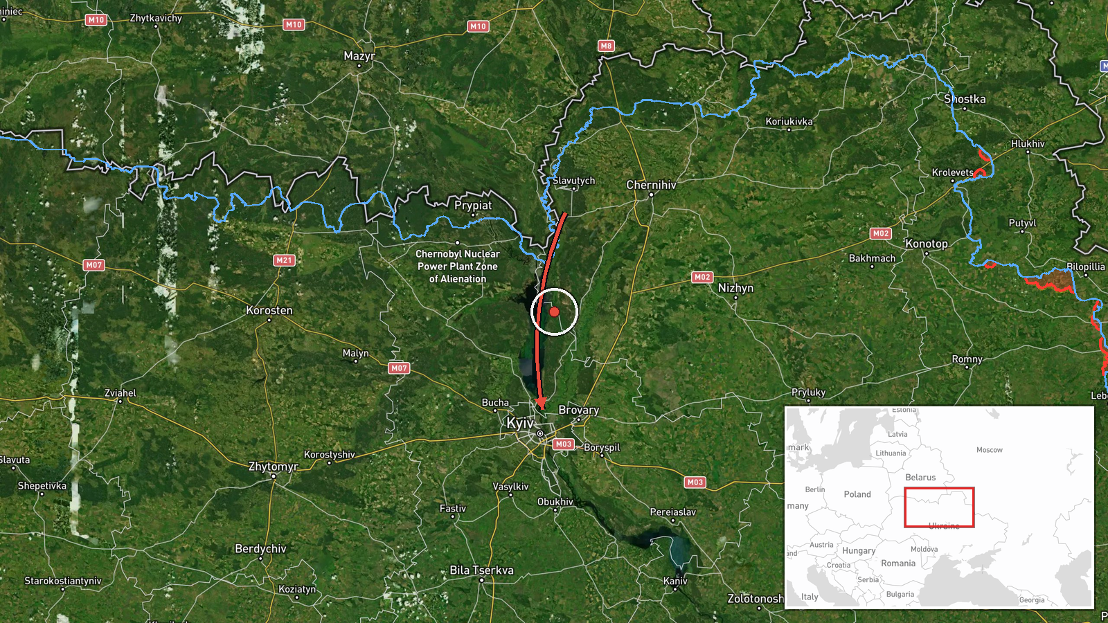
Ukrainian air monitoring reports at least two Russian jet-powered Shahed drones, designated Geran-3 in the report, passing Slavutych and heading toward Kyiv Oblast. The item was posted on Telegram under the handle @kpszsu with a timestamp of 03:00 UTC on 23 October 2026. The original Ukrainian post places the sighting under Chernihiv region and describes the drones as jet-type unmanned aerial vehicles flying past Slavutych on a course for Kyiv Oblast. It gives no information on impacts, damage, or casualties. The report describes a transit track rather than a confirmed strike. The event is attributed to Russia on the basis of the channel's framing and the classification in the dataset.
Context and assessment
The event sits within a sequence of drone transit reports on 22 and 23 October. Related entries show a single Geran-3 passing Zhashkiv at 17:00 on 22 October, then at 00:18 a group of at least two Shahed-type drones moving from northern Chernihiv toward Kyiv Oblast. Further reports followed at 00:19 for one Shahed-type drone heading toward Kyiv, at 01:04 for at least two Geran-3 over the city, and at 03:14 for at least two Geran-3 again over Kyiv. The pattern is repeated small groups tracking along a corridor from the north toward the capital over roughly ten hours. Kyiv is the country's political center and the seat of its main military command, so sustained overflight reports there can strain air defense and warning systems even when no impact is recorded. The jet-powered Geran-3 variant is generally faster than the piston-engine Shahed-136 type, which can shorten warning times for residents and interceptors. The flight pattern may reflect routing toward several targets, decoy use, or an effort to draw air defense fire. The available data cannot distinguish among these explanations.
Sources and confidence
The event rests on one channel, Telegram @kpszsu, and no second outlet or official statement appears in the dataset. The confidence score of 8.0 reflects a source with a clear timestamp, specific wording, and a pattern consistent with the related reports in the same area. It is held below the top range because the item is single-sourced, and because the regional label in the original post (Chernihiv) does not match the Kyiv Oblast pin. Confidence would rise with independent air monitoring reports, official Ukrainian Air Force statements, or regional military administration confirmation. It would fall if later reporting revised the track or the drone identification.
Location
The coordinates 50.45, 30.52 fall in central Kyiv, not on the flight path, and are assigned at region precision with low location confidence. The event is therefore not pinned to a settlement along the route. Slavutych is a city in northern Ukraine close to the Chernihiv border and the Chernobyl exclusion zone. The track runs south toward Kyiv Oblast across lowland terrain, forest belts, and river valleys in the Dnipro basin. These features are general background rather than details from the report.
Related events nearby
- Ukrainian air monitoring: 2+ Russian jet-powered Shahed (Geran-3) drones over Kyiv.2026-10-23 03:14 UTC · Drone Transit · Kyiv, Ukraine
- Ukrainian air monitoring: 2+ Russian jet-powered Shahed (Geran-3) drones over Kyiv.2026-10-23 01:04 UTC · Drone Transit · Kyiv, Ukraine
- Ukrainian air monitoring: 1 Russian Shahed-type drone heading toward Kyiv.2026-10-23 00:19 UTC · Drone Transit · Kyiv, Ukraine
- Ukrainian air monitoring: 2+ Russian Shahed-type drones from northern Chernihiv Oblast toward Kyiv Oblast.2026-10-23 00:18 UTC · Drone Transit · Kyiv Oblast, Ukraine
- Ukrainian air monitoring: 1 Russian jet-powered Shahed (Geran-3) drone passing Zhashkiv, heading toward Kyiv O2026-10-22 17:00 UTC · Drone Transit · Kyiv Oblast, Ukraine
▶ View this event on the live map

Intel Mapper aggregates open-source reports from monitored Telegram and X channels, geolocates them, cross-checks duplicates across sources and assigns a confidence score. Entries are updated as new confirmations arrive. Read how we verify events.