Russian jet-powered Shahed drones reported passing Liubech toward Kyiv Oblast
What happened
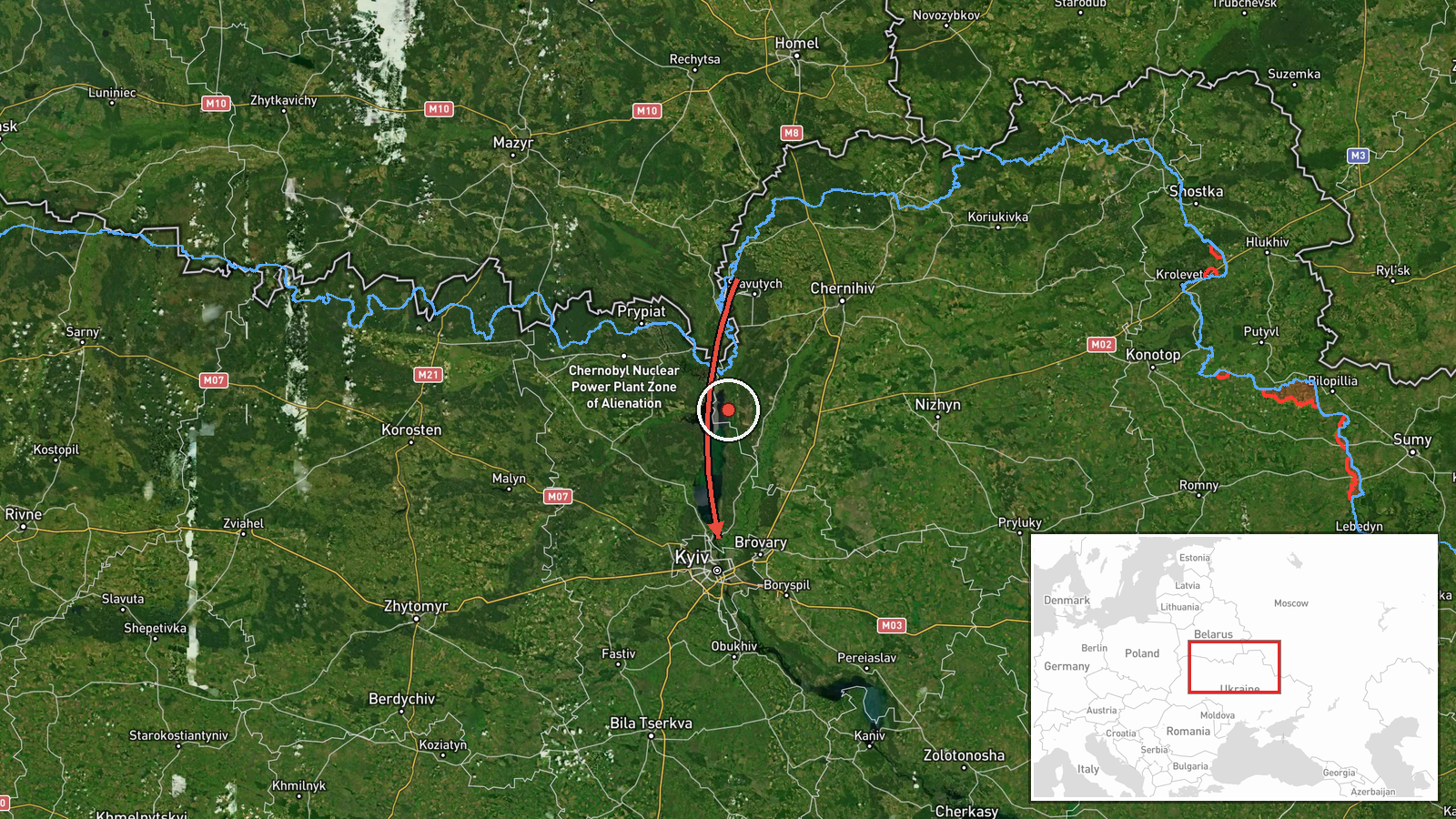
Ukrainian air monitoring reported at 02:05 UTC on 18 October 2026 that at least two Russian jet-powered Shahed (Geran-3) drones were passing Liubech, a settlement in Chernihiv Oblast on the Dnipro, and heading toward Kyiv Oblast. The report was posted on the Telegram channel @kpszsu, which carries Ukrainian air-monitoring updates. The original Ukrainian wording is brief: jet-type drones (reactive UAVs) moving past Liubech in the direction of Kyiv Oblast. The post does not describe impacts, casualties, or damage. The event record lists Kyiv Oblast as the location because that is the destination region of the transit, not the point where the drones were observed.
Context and assessment
This report belongs to a cluster of five drone-transit events logged between 04:07 UTC on 17 October and 02:02 UTC on 18 October 2026, all directed at Kyiv or Kyiv Oblast. Earlier reports describe drones entering from Belarus, moving through northern Chernihiv Oblast and Cherkasy Oblast, and passing Hlevakha heading west. The route pattern suggests that the drones were being routed through several corridors into the capital area rather than arriving from a single direction. Kyiv matters as a target because it hosts national government, energy and transport infrastructure, and a large population, although transit reports do not identify intended targets. The jet-powered Geran-3 variant is generally understood to be faster than the older piston-engined Geran-2, which affects warning times and interception planning. Taken together, the reports may indicate sustained overnight waves using multiple approach lines, possibly to saturate air defences. Transit observations alone cannot confirm intent or the scale of any strike that may have followed.
Sources and confidence
The event rests on a single Telegram channel, @kpszsu, and the record shows no independent confirmation. The confidence score of 8.0 reflects a credible monitoring source with a consistent reporting history in this cluster, but it is held below the top range because nothing outside that channel corroborates the sighting. Confidence would rise with matching statements from Ukrainian air force or regional military administrations, consistent flight-tracking or radar-based open-source data, or later reports of drone debris or interceptions in the area. It would fall if the reported direction or type were disputed, if a correction were issued, or if no subsequent sightings or impacts appeared in the same window.
Location
The location is recorded only at oblast level as Kyiv Oblast, with low location confidence. The coordinates given (50.45, 30.52) fall in the Kyiv area and are a placeholder for the region rather than Liubech itself, which lies further north on the Dnipro in Chernihiv Oblast. The surrounding terrain is largely flat Dnipro lowland with river valleys, reservoirs, and forest belts. The Dnipro and Desna valleys are natural guides for low-flying drones, so the river corridor is a relevant feature of this transit route.
Related events nearby
- Ukrainian air monitoring: 1 Russian Shahed-type drone over Kyiv Oblast.2026-10-18 02:02 UTC · Drone Transit · Kyiv Oblast, Ukraine
- Ukrainian air monitoring: 1 Russian jet-powered Shahed (Geran-3) drone from Cherkasy Oblast toward Kyiv Oblast2026-10-17 15:51 UTC · Drone Transit · Kyiv Oblast, Ukraine
- Ukrainian air monitoring: 2+ Russian jet-powered Shahed (Geran-3) drones from northern Chernihiv Oblast toward2026-10-17 09:45 UTC · Drone Transit · Kyiv Oblast, Ukraine
- Ukrainian air monitoring: 1 Russian Shahed-type drone from Belarus toward Kyiv Oblast.2026-10-17 06:39 UTC · Drone Transit · Kyiv Oblast, Ukraine
- Ukrainian air monitoring: 1 Russian Shahed-type drone heading toward Kyiv; 1 Russian jet-powered Shahed (Geran2026-10-17 04:07 UTC · Drone Transit · Kyiv, Ukraine
▶ View this event on the live map

Intel Mapper aggregates open-source reports from monitored Telegram and X channels, geolocates them, cross-checks duplicates across sources and assigns a confidence score. Entries are updated as new confirmations arrive. Read how we verify events.