Shahed-type drone reportedly passes Slavutych toward Kyiv Oblast, Ukrainian monitors report
What happened
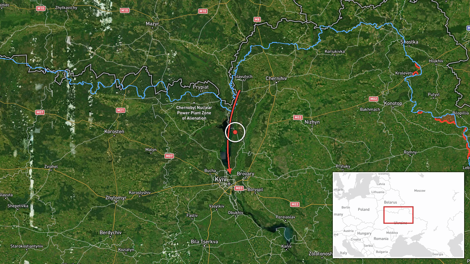
Ukrainian air monitoring reported on 18 October 2026, at about 04:05 UTC, that one Russian Shahed-type drone was passing Slavutych and heading toward Kyiv Oblast. The alert was posted on Telegram by the Ukrainian Air Force monitoring channel @kpszsu. The original Ukrainian wording describes strike UAVs (ударні БпЛА) moving past Slavutych on a course toward Kyiv Oblast, from the Chernihiv region. The report gives no impact, damage, casualty, or interception details. It describes only a transit track, and the attribution to Russia comes from the channel's standard framing of Shahed-type drones.
Context and assessment
The event fits a sustained pattern of drone transits moving through northern Ukraine toward the Kyiv area. Within roughly fifteen hours before this report, the same monitoring channel logged several overlapping tracks into Kyiv Oblast. These included a drone from Belarus, jet-powered Geran-3 drones from northern Chernihiv Oblast, a single drone from Cherkasy Oblast, and a group of at least two jet-powered Shahed variants passing Liubech. The repeated use of Chernihiv and Belarusian airspace as entry corridors suggests that launch and routing decisions are being shaped by the northern approach to the capital. Single-drone transits like this one are often reported as individual tracks as the air picture changes, and a lone track does not by itself indicate a larger raid. Analysts would typically look for whether this drone is followed by additional tracks in the same corridor, or whether it is one element of a larger salvo that will strike elsewhere. Pattern continuity matters more than any single track.
Sources and confidence
The event rests on a single Telegram channel, @kpszsu, which is the Ukrainian Air Force's official monitoring feed. No other outlet in the data set independently confirms this specific track. The confidence score of 8.0 reflects that the channel is an official, historically consistent source of air alerts, but it is still one channel without corroboration or impact reporting. The score would rise if regional military administrations, independent trackers, or radar-based tracking services confirmed the same route and timing. It would fall if the track were later revised, withdrawn, or found to refer to a different aircraft.
Location
The location is recorded as Kyiv Oblast at region level, with coordinates of 50.45 N, 30.52 E. These are a generalized point, not a precise fix. The original text places the drone near Slavutych, a city in northern Kyiv Oblast close to the Chernihiv border and the Chornobyl exclusion zone. The region-level precision and the low location confidence mean the pin should be read as the approximate area of the track, not as the drone's exact path. The terrain is largely flat, with wooded areas and the Desna and Dnipro river basins to the east and north.
Related events nearby
- Ukrainian air monitoring: 2+ Russian jet-powered Shahed (Geran-3) drones passing Liubech, heading toward Kyiv 2026-10-18 02:05 UTC · Drone Transit · Kyiv Oblast, Ukraine
- Ukrainian air monitoring: 1 Russian Shahed-type drone over Kyiv Oblast.2026-10-18 02:02 UTC · Drone Transit · Kyiv Oblast, Ukraine
- Ukrainian air monitoring: 1 Russian jet-powered Shahed (Geran-3) drone from Cherkasy Oblast toward Kyiv Oblast2026-10-17 15:51 UTC · Drone Transit · Kyiv Oblast, Ukraine
- Ukrainian air monitoring: 2+ Russian jet-powered Shahed (Geran-3) drones from northern Chernihiv Oblast toward2026-10-17 09:45 UTC · Drone Transit · Kyiv Oblast, Ukraine
- Ukrainian air monitoring: 1 Russian Shahed-type drone from Belarus toward Kyiv Oblast.2026-10-17 06:39 UTC · Drone Transit · Kyiv Oblast, Ukraine
▶ View this event on the live map

Intel Mapper aggregates open-source reports from monitored Telegram and X channels, geolocates them, cross-checks duplicates across sources and assigns a confidence score. Entries are updated as new confirmations arrive. Read how we verify events.