Single Russian Geran-3 drone reported moving from Vinnytsia into Khmelnytskyi Oblast toward Derazhnya
What happened
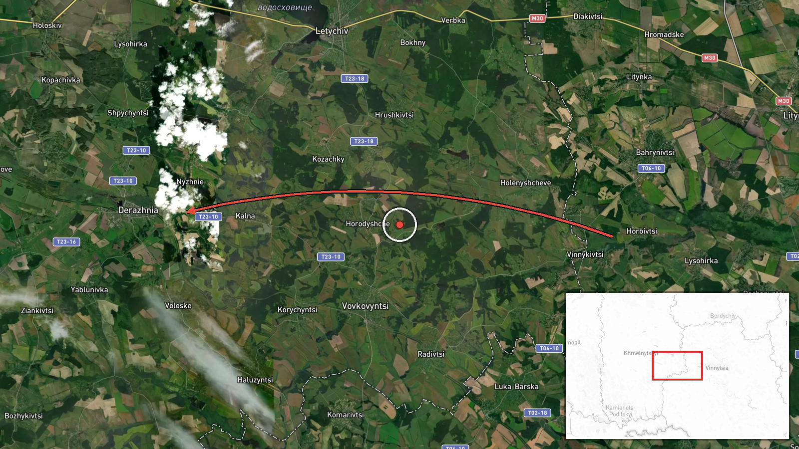
On 18 October 2026 at 06:47 UTC, a Ukrainian air monitoring channel on Telegram (@kpszsu) reported one jet-powered Shahed-type drone, identified as a Geran-3, moving from Vinnytsia Oblast into Khmelnytskyi Oblast on a course toward the settlement of Derazhnya. The original Ukrainian post is brief, describing a jet-type unmanned aerial vehicle heading from the Vinnytsia region to the Khmelnytskyi region on a course toward Derazhnya. The report does not describe any impact, debris, air defence engagement, or casualties, and it does not state where the drone was ultimately headed beyond the Derazhnya bearing. The wording reflects an airspace alert rather than a confirmed strike.
Context and assessment
Derazhnya sits in western Ukraine, a region that has seen repeated drone transits in recent months as Russian long-range strike packages cross from the east and centre toward targets in the west. The related events in this sequence show a consistent pattern over roughly seventeen hours. At 14:13 UTC on 17 October, a single Shahed-type drone was reported over Khmelnytskyi Oblast. At 14:25 another was seen passing Derazhnya toward Khmelnytskyi. At 15:13 a drone was tracked toward Vinkivtsi, also in the oblast. Early on 18 October, one Geran-3 was reported from Vinnytsia Oblast toward Khmelnytskyi at 06:34, then over Khmelnytskyi at 06:38, before the Derazhnya report. Operationally, the repeated single-airframe tracks along a similar corridor suggest routing through the oblast, possibly as a transit lane toward targets further west, or as reconnaissance or saturation-style probing. The jet-powered Geran-3 is faster than the older piston-engine variants, which may shorten warning times and is one reason such reports prompt alerts. Because the data contains no outcome, these readings remain hedged interpretations.
Sources and confidence
The report comes from a single Telegram channel, @kpszsu, which is the Ukrainian air monitoring feed. The data lists no independent second source, wire service, or regional military administration confirmation for this specific event. Confidence is scored at 8.0, which is relatively high because the channel is an official-style monitoring source with a consistent pattern of timed track reports, and the related events come from the same feed and align geographically. It is held below the maximum because cross-confirmation is absent and the reports describe trajectories rather than verified outcomes. Confidence would rise with corroboration from regional authorities, air defence statements, or debris and impact reports. It would fall if the channel issued a correction, if later tracks contradicted the stated bearing, or if no subsequent reporting matched the sequence.
Location
The location is assigned at settlement level to Derazhnya, a small town in Khmelnytskyi Oblast, west-central Ukraine, with coordinates near 49.27 N, 27.43 E. The precision reflects that the report names a settlement as the drone's heading rather than a specific facility, so the point marks the town rather than a target. The area lies in the western lowland and forest-steppe transition, with agricultural land, river valleys, and the administrative boundary with Vinnytsia Oblast to the south and east. Nearby transit points named in the related reports include Khmelnytskyi city and Vinkivtsi.
Related events nearby
- Ukrainian air monitoring: 1 Russian jet-powered Shahed (Geran-3) drone from Khmelnytskyi Oblast toward Vinkivt2026-10-17 15:13 UTC · Drone Transit · Vinkivtsi, Ukraine
- Ukrainian air monitoring: 1 Russian jet-powered Shahed (Geran-3) drone over Khmelnytskyi.2026-10-18 06:38 UTC · Drone Transit · Khmelnytskyi, Ukraine
- Ukrainian air monitoring: 1 Russian jet-powered Shahed (Geran-3) drone from Vinnytsia Oblast toward Khmelnytsk2026-10-18 06:34 UTC · Drone Transit · Khmelnytskyi, Ukraine
- Ukrainian air monitoring: 1 Russian Shahed-type drone passing Derazhnya, heading toward Khmelnytskyi.2026-10-17 14:25 UTC · Drone Transit · Khmelnytskyi, Ukraine
- Ukrainian air monitoring: 1 Russian Shahed-type drone over Khmelnytskyi Oblast.2026-10-17 14:13 UTC · Drone Transit · Khmelnytskyi Oblast, Ukraine
▶ View this event on the live map

Intel Mapper aggregates open-source reports from monitored Telegram and X channels, geolocates them, cross-checks duplicates across sources and assigns a confidence score. Entries are updated as new confirmations arrive. Read how we verify events.