Ukrainian air monitoring reports one Russian Shahed-type drone moving from the Black Sea toward Odesa
What happened
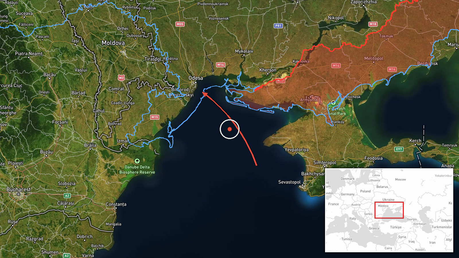
Ukrainian air monitoring reported on Telegram via the channel @kpszsu that one Russian Shahed-type drone was over the Black Sea heading toward Odesa at about 18:23 UTC on 19 October 2026. The original post describes the object as an unmanned aerial vehicle (БпЛА) in the Black Sea water area moving in the direction of Odesa. The report is brief and does not state whether the drone was intercepted, whether it struck anything, or whether any damage or casualties occurred. The event is recorded as a drone transit rather than a confirmed impact. Because the wording is a single operational alert, the details reflect the monitoring channel's assessment at the time of posting and may be updated.
Context and assessment
Odesa is Ukraine's major Black Sea port and a regional hub for grain shipping, energy infrastructure and military logistics, which makes it a recurring target of long-range drone activity. The related events on the same day show a sustained pattern of jet-powered Shahed (Geran-3) drones entering from the Black Sea and moving north across the Odesa, Mykolaiv and Kherson-adjacent corridor. Reports at 03:07, 05:25, 06:28 and 06:53 UTC describe groups or single drones aimed at southern Mykolaiv Oblast, Ochakiv and the area north of Buialyk, and a further report at 14:02 UTC notes drones on the Odesa-Mykolaiv border heading north. Taken together, this suggests a rolling series of routes that approach from the sea and track along the coast toward inland targets, rather than an isolated launch. Operationally, such transits may indicate an effort to saturate air defence along the coastal belt or to strike infrastructure in the region, though the monitoring data alone does not establish intent or target selection.
Sources and confidence
The event rests on a single Telegram channel, @kpszsu, which is the official Ukrainian air-force-linked monitoring account often used for real-time drone alerts. No independent outlet or second channel is recorded for this specific report, so cross-confirmation is absent. The confidence score of 8.0 reflects the channel's official character and the consistency with the same-day pattern of similar alerts, but it is not higher because the post gives no outcome and the single-source status cannot be verified here. Confidence would rise with corroboration from local Odesa authorities, an interception or impact report, or a second independent monitoring feed. It would fall if the drone is later identified as a different type, as a false track, or if the timing is revised.
Location
The location is recorded at settlement precision for Odesa, with high location confidence and coordinates of roughly 46.48 N, 30.73 E. The alert names the Black Sea approach toward the city, so the point represents the city rather than a specific facility or the exact track. Odesa sits on the northwestern Black Sea coast near the Dnipro-Bug estuary region and the Odesa Gulf, with the port, the old town and the coastal districts lying close to the shoreline. The city is backed by the Kuyalnik and Khadzhibey estuaries to the east and the broader steppe to the north, which shape the approach corridors used by drones coming off the sea.
Related events nearby
- Ukrainian air monitoring reports jet-powered Shahed (Geran-3) drones on the Odesa-Mykolaiv border, heading nor2026-10-19 14:02 UTC · Drone Transit · Odesa-Mykolaiv Oblast border, Ukraine
- Ukrainian air monitoring: 1 Russian jet-powered Shahed (Geran-3) drone from Black Sea toward Ochakiv.2026-10-19 06:28 UTC · Drone Transit · Ochakiv, Ukraine
- Ukrainian air monitoring: 1 Russian jet-powered Shahed (Geran-3) drone passing north of Buialyk, heading north2026-10-19 05:25 UTC · Drone Transit · north of Buialyk, Ukraine
- Ukrainian air monitoring: 1 Russian jet-powered Shahed (Geran-3) drone from Black Sea toward southern Mykolaiv2026-10-19 06:53 UTC · Drone Transit · southern Mykolaiv Oblast, Ukraine
- Ukrainian air monitoring: 2+ Russian jet-powered Shahed (Geran-3) drones heading toward southern Mykolaiv Obla2026-10-19 03:07 UTC · Drone Transit · southern Mykolaiv Oblast, Ukraine
▶ View this event on the live map

Intel Mapper aggregates open-source reports from monitored Telegram and X channels, geolocates them, cross-checks duplicates across sources and assigns a confidence score. Entries are updated as new confirmations arrive. Read how we verify events.