Single jet-powered Shahed (Geran-3) drone reported passing Kyiv Reservoir toward Vyshhorod
What happened
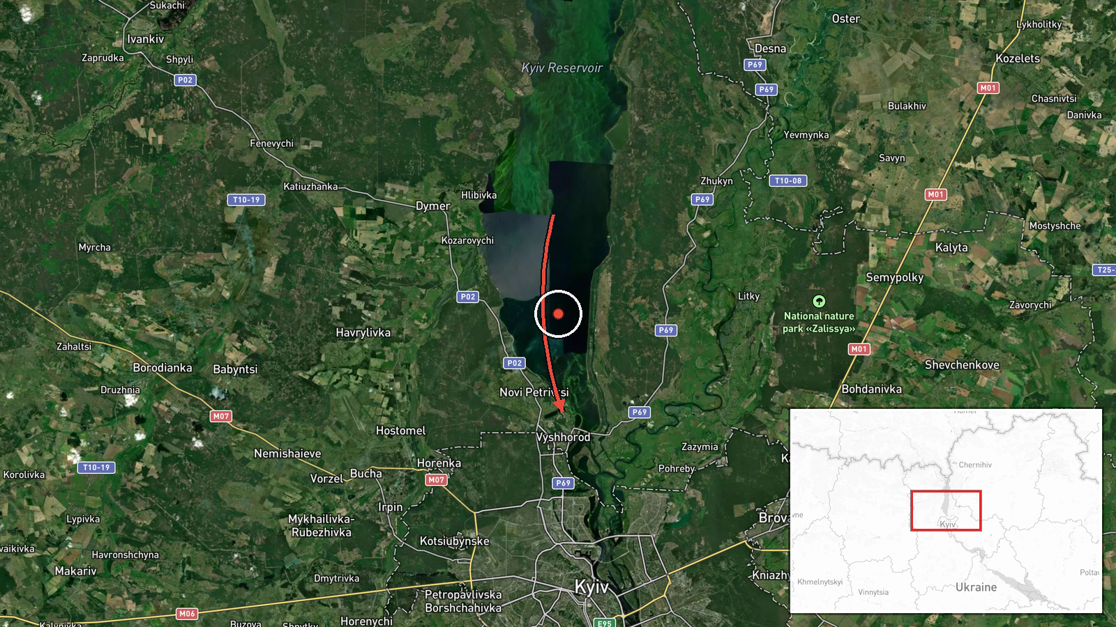
Ukrainian air monitoring reported on Telegram channel @kpszsu that one Russian jet-powered Shahed-type drone, described in the source as a Geran-3, was passing the Kyiv Reservoir on a course toward Vyshhorod and Kyiv. The report was logged at 05:24 UTC on 23 October 2026. The original Ukrainian-language post, roughly translated, reads: a jet-powered UAV passing the Kyiv Reservoir on a course of Vyshhorod/Kyiv. The wording describes a transit, not a confirmed impact, and no damage, casualties or interception are stated in the report. The location is given as Vyshhorod, a town north of Kyiv on the Dnipro.
Context and assessment
Vyshhorod sits on the Dnipro just north of the capital, and the Kyiv Reservoir lies along the river corridor that drones often follow when approaching the city from the north. This single track fits a broader pattern visible in the related reports from the same night. Between 00:18 and 03:14 UTC, monitoring channels logged repeated Shahed-type transits from northern Chernihiv Oblast into Kyiv Oblast, followed by groups of two or more jet-powered Geran-3 drones over Kyiv itself and near Slavutych. The sequence suggests a sustained wave of long-range drone traffic moving southward toward the capital rather than an isolated flight. Operationally, the Geran-3 variant is generally understood to be faster than earlier piston-engined Shaheds, which can shorten the warning window for air defense crews and complicate interception along the river approaches. A lone drone on a northern approach may be a trailing element of a larger salvo, a decoy, or a drone rerouted by defenses, though the report alone cannot establish which.
Sources and confidence
The only source is the Telegram channel @kpszsu, associated with Ukraine's air force monitoring. No independent outlet or second channel in the provided data reports this specific transit, so cross-confirmation is absent. The confidence score of 8.0 reflects a credible official-style monitoring feed with a precise timestamp and a clearly stated track, but it is held below the top range because it is single-sourced and reports movement rather than outcome. Confidence would rise with corroboration from additional monitoring channels, radar-based tracking statements, or reports of an impact or interception near Vyshhorod. It would fall if the track were revised, or if later updates placed the drone elsewhere.
Location
The location is coded as Vyshhorod at settlement precision with high location confidence, placing the marker at roughly 50.58 N, 30.49 E. The point represents the town, not a specific facility, since the report names only the reservoir and the course. Geographically, Vyshhorod lies on the right bank of the Dnipro north of Kyiv, with the Kyiv Reservoir extending upstream to the north and west. The reservoir and the river valley form a broad open corridor, and the Kyiv Hydroelectric Power Station and the Dnipro channel are notable nearby features that help define the approach route.
Related events nearby
- Ukrainian air monitoring: 1 Russian jet-powered Shahed (Geran-3) drone heading toward Troieshchyna, Kyiv.2026-10-23 05:31 UTC · Drone Transit · Troieshchyna, Kyiv, Ukraine
- Ukrainian air monitoring: 2+ Russian jet-powered Shahed (Geran-3) drones over Kyiv.2026-10-23 03:14 UTC · Drone Transit · Kyiv, Ukraine
- Ukrainian air monitoring: 2+ Russian jet-powered Shahed (Geran-3) drones passing Slavutych, heading toward Kyi2026-10-23 03:00 UTC · Drone Transit · Kyiv Oblast, Ukraine
- Ukrainian air monitoring: 2+ Russian jet-powered Shahed (Geran-3) drones over Kyiv.2026-10-23 01:04 UTC · Drone Transit · Kyiv, Ukraine
- Ukrainian air monitoring: 1 Russian Shahed-type drone heading toward Kyiv.2026-10-23 00:19 UTC · Drone Transit · Kyiv, Ukraine
▶ View this event on the live map

Intel Mapper aggregates open-source reports from monitored Telegram and X channels, geolocates them, cross-checks duplicates across sources and assigns a confidence score. Entries are updated as new confirmations arrive. Read how we verify events.