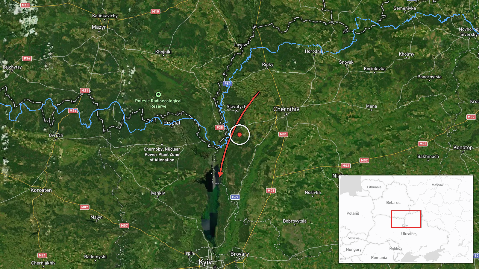
One Geran-3 jet drone reported crossing from Chernihiv into northern Kyiv Oblast
What happened
Ukrainian air monitoring channel @kpszsu, the Ukrainian Air Force's Telegram account, reported on 23 October 2026 at about 07:00 UTC that a single jet-powered Shahed-type drone, identified in the post as a Geran-3, had moved from the north of Chernihiv Oblast into the north of Kyiv Oblast. The original Ukrainian wording describes a 'reactive UAV' flying from northern Chernihiv region toward the north of Kyiv region, and the summary attributes the drone to Russia. The report gives no impact point, no damage assessment and no casualty information, and the track is described only at regional level. Because this single channel is the only source recorded, the details remain unconfirmed by independent reporting.
Context and assessment
This entry is one of a run of single-drone transit reports that began the previous day. Earlier on 22 October, the same channel reported jet-powered Geran-3 drones tracked through the Chornobyl Exclusion Zone heading west, and a group of two or more drones moving from northern Kyiv Oblast toward Bucha. On 23 October, further single-drone tracks were logged passing the Kyiv Reservoir toward Vyshhorod, heading toward Troieshchyna on the western edge of Kyiv, and heading toward Desna. Taken together, the pattern shows drones entering from the north and crossing the sparsely populated Chornobyl zone and the river corridors of the Dnipro and Desna before approaching the Kyiv approaches. Operationally, such a sequence may point to reconnaissance or route-testing along a northern axis, to decoy or saturation planning, or simply to the normal routing of long-range drones toward targets further south or east. Reports of this kind do not on their own identify an intended target, and the jet-powered variant's higher speed means tracks can be shorter and harder to follow.
Sources and confidence
The entry rests on one Telegram channel, which posts real-time air monitoring updates and is not independently verified in the record. Its confidence score of 8.0 reflects the channel's established role in tracking drone movements and the internal consistency of the surrounding track reports, but it is not a cross-confirmed score. Confidence would rise with independent corroboration from Ukrainian regional military administrations, official Air Force statements, or other monitoring channels showing the same track. It would fall if a later update corrected the origin or direction, or if the track were attributed to a different drone type or to a decoy.
Location
Location precision is region-level and location confidence is low; the coordinates are an approximate point within northern Kyiv Oblast rather than a settlement or facility, and no origin point is recorded. The area is part of the Polissia lowlands, a flat to gently rolling landscape of forest, wetland and farmland, crossed by the Desna and Dnipro river valleys. The Chornobyl Exclusion Zone lies to the north, and the Kyiv Reservoir and the Dnipro corridor lie to the south and east.
Related events nearby
- Ukrainian air monitoring: new jet-powered Shahed (Geran-3) drones tracked through the Chornobyl Exclusion Zone2026-10-22 17:12 UTC · Drone Transit · Chornobyl Exclusion Zone, Ukraine
- Ukrainian air monitoring: 1 Russian jet-powered Shahed (Geran-3) drone from Chernihiv Oblast toward Kozelets.2026-10-23 07:58 UTC · Drone Transit · Kozelets, Ukraine
- Ukrainian air monitoring: 1 Russian jet-powered Shahed (Geran-3) drone passing Kyiv Reservoir, heading toward 2026-10-23 05:24 UTC · Drone Transit · Vyshhorod, Ukraine
- Ukrainian air monitoring: 1 Russian jet-powered Shahed (Geran-3) drone heading toward Desna.2026-10-23 07:09 UTC · Drone Transit · Desna, Ukraine
- Ukrainian air monitoring: 1 Russian jet-powered Shahed (Geran-3) drone heading toward Troieshchyna, Kyiv.2026-10-23 05:31 UTC · Drone Transit · Troieshchyna, Kyiv, Ukraine
▶ View this event on the live map

Intel Mapper aggregates open-source reports from monitored Telegram and X channels, geolocates them, cross-checks duplicates across sources and assigns a confidence score. Entries are updated as new confirmations arrive. Read how we verify events.